 |
| Tern Lake, Kenai Peninsula |
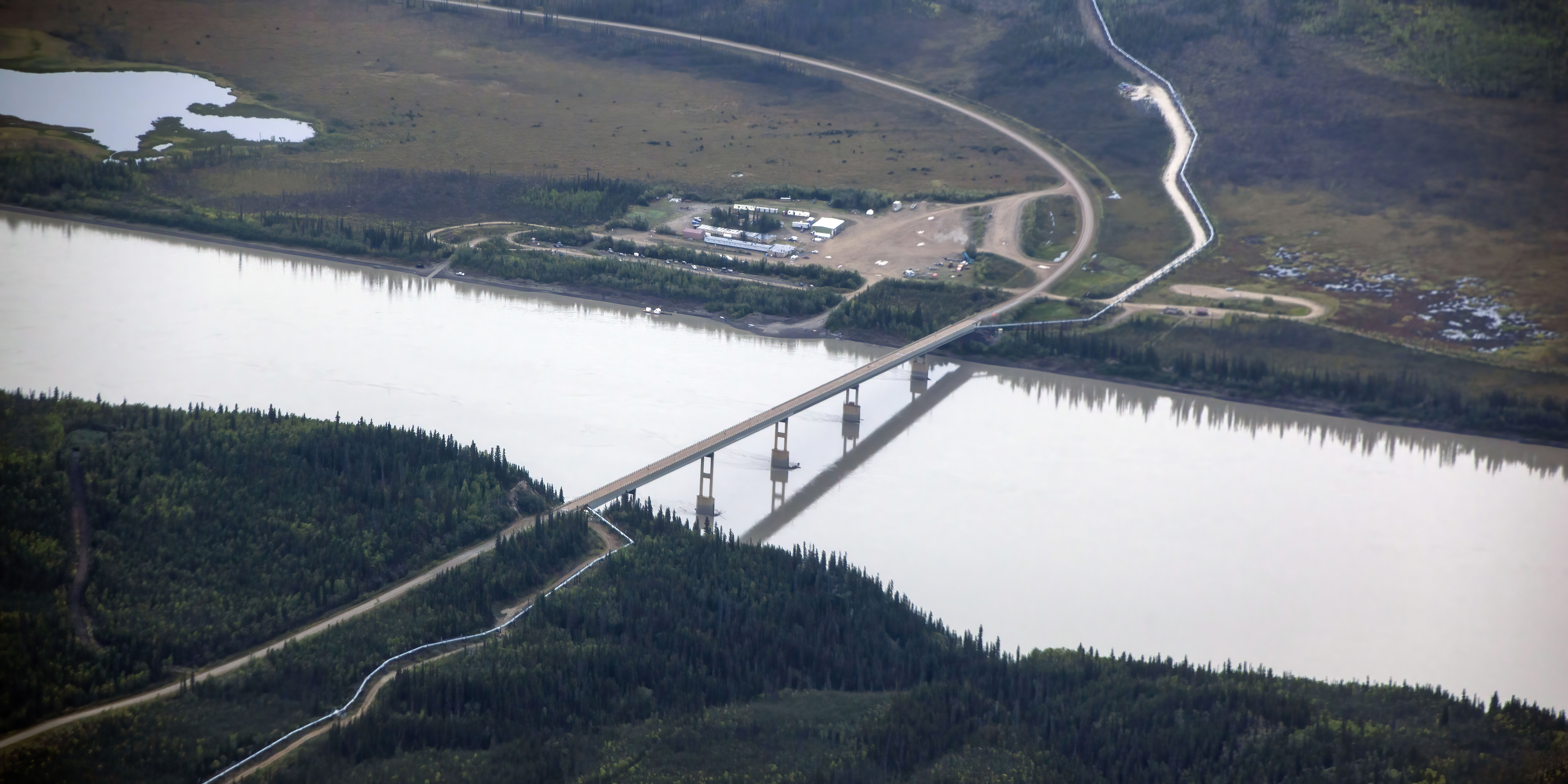
Dalton Highway
 |
| You can't get much more Alaskan than this |
I talked a bit about the Dalton Highway in my discussion of the tiny towns of Coldfoot and Wiseman, but here's a little more information if you decide to venture that way yourself.
The highway has many names: is appears on signs as Alaska Route 11; its official name is the James W. Dalton Highway; it is often called the Dalton Highway or the Haul Road. For years, I thought Scott was saying "Hall Road," which made no sense. "Haul" does because it is the road built and used to haul supplies to the Prudhoe Bay Oil Fields.
The Dalton Highway is actually 414 miles long, going from the Elliott Highway, north of Fairbanks, to Deadhorse in Prudhoe Bay near the Arctic Ocean. But, when considering the drive, most people calculate in the 80 miles from Fairbanks to the road's starting point for a total of 494 miles.
 |
| A long road |
The road was originally called the North Slope Haul Road when it was built as a supply road to support the Trans-Alaska Pipeline System in 1974. It is named after James Dalton, a lifelong Alaskan and an engineer who supervised construction of the Distant Early Warning Line in Alaska and, as an expert in Arctic engineering, served as a consultant in early oil exploration in northern Alaska.
 |
| The road was needed for oil operations |
In 1966, the North Slope was opened to oil extraction. In 1968-1969, the state built a road heading farther west than where the Dalton Highway now is. That road lasted only one month because it was not engineered to deal with permafrost!
Still needing a road, the Alyeska Pipeline Service Company funded what would be the first stretch of the Dalton Highway from Livengood to the Yukon River in 1969.
Delays in pipeline construction and, therefore the road, halted work until 1974 when 390 more miles were built. The pipeline was completed in 1977.
 |
| The Trans-Alaska Pipeline |
In 1979, Alyeska turned over control of the road to the state of Alaska, which gave it its official name. In 1981, the highway was opened to the public up to Disaster Creek at Mile 211. In 1994, the public was allowed access to the entire length of the highway. Scott first visited in 2003 and both of us went the following year. Although the tour we went on is no longer offered, one of our guides, Hugh Rose, does offer a similar one. I highly recommend it.
 |
| Map: Rider Magazine |
The highway, which directly parallels the pipeline, is one of the most isolated roads in the U.S.
There are only three towns along the route: Coldfoot at Mile 175, Wiseman at Mile 188 and Deadhorse at mile 414. Deadhorse has less than 25 permanent residents and 3,500 to 5,000 or more seasonal residents, depending on oil production.
Two other settlements, Prospect Creek and Galbraith Lake, are uninhabited except for campers and other short-term residents.
 |
| The entire 414-mile road is above the Arctic Circle |
There is a truck stop in Coldfoot; lodging in Coldfoot, Wiseman and Deadhorse and no rest stops (I think there was one when I visited, but I can't find any mention of it now). I already talked about Coldfoot and Wiseman. There are three hotels in Deadhorse that mainly serve the oil industry.
Fuel is available at the E.L. Patton Yukon River Bridge at Mile 56, as well as in Coldfoot and Deadhorse.
 |
| After the Yukon River Bridge, it gets wild |
The nearest medical facilities are in Fairbanks and Deadhorse. The first cell tower went up in 2017 and service is still available only on a fraction of the route.
It is very primitive in places, with a number of steep grades, some as severe as 12 percent.
 |
| Curving around and up the pass |
Of the 414 miles, only 129 are paved. The rest is gravel. Flying rocks from passing trucks can destroy a windshield.
 |
| A Red Fox walking along the Highway; Photo: Scott Stevens |
Add that to unpredictable and highly variable weather and the frequency of heavily loaded "I-own-the-road" big rigs and it is evident that cars and motorcycles must be very careful. Headlights must be on at all times.
Most rental cars are not allowed on the Dalton Highway; instead you need to find an outfitter that will lease a car to traverse the treacherous road. Lists I have seen include Arctic Outfitters, Alaska 4X4 Rentals, Alaska Overlander or Alaska Auto Rental (you must rent a "gravel highway vehicle"). I haven't used any of theses, so check first.
Anyone embarking on a journey on the Dalton is encouraged to bring adequate supplies, good spare tires and survival gear.
 |
| Wear warm clothes (yes, that's a Grizzly behind Scott); Right photo: Scott Stevens |
Despite its remoteness, the Dalton Highway carries a good amount of truck traffic through to Prudhoe Bay: about 160 trucks daily in the summer and 250 trucks daily in the winter.
That sounds weird at first: more traffic in the winter than in the summer. But, many Oil Field operations can happen only in winter when sub-zero temperatures prevent permafrost melting and allow for construction of ice roads to carry heavy equipment.
In like fashion, the Dalton Highway is actually an easier drive in winter, where it is purposefully sprayed with water to form a smoother ice layer.
In summer, it can be pot-holed, muddy or boggy. Pulling off is just an invitation to get stuck. Stopping is an invitation to get hit, or at minimum harassed, by a truck driver.
 |
| A risky stance |
Of course, in summer, you get unlimited light. In winter, its dark and cold (-82°F anyone?).
 |
| Evening; Photo: Scott Stevens |
The Dalton Highway comes to within a few miles of the Arctic Ocean, but ocean access is via private roads owned by the oil companies and restricted to authorized vehicles. There are, however, commercial tours that take people to the Arctic Ocean.
 |
| Dall Sheep at Atigun Pass; Photo: Scott Stevens |
The road reaches its highest elevation as it crosses the Brooks Range at Atigun Pass at 4,739 feet.
When Scott first went, the tour's van failed to climb the pass on first attempt, sliding backwards on the icy road.
They had to increase speed to reach the top.
There are 40 to 50 avalanche paths along Atigun Pass. Because an avalanche could close the pass, the Alaska Department of Transportation uses 11-foot-long avalanche guns to shoot down potential slides.
 |
| Avalanche-prone |
The Dalton Highway has been featured on the History Channel reality television series Ice Road Truckers. It was also the subject of the second episode of America's Toughest Jobs and the first episode of the BBC's World's Most Dangerous Roads.
So, why go? Lots of reasons ...
Novelty ...
 |
| Where else can you see this? Photo: Scott Stevens |
Beautiful other-worldly vistas ...
 |
| Especially when the landscape is covered with snow |
Interesting landscape ...
 |
| Finger rock is a tor, a rock formation caused by freeze/thaw weathering |
Weird atmospheric phenomena ...
 |
| Aurora borealis shots flanking a sundog; Left and right photos: Scott Stevens |
Adventure ...
 |
| For us, adventure is photography |
Animals ...
 |
| CW: Dall Sheep, Arctic Fox*, Brown Bear*, Spruce Grouse*, Alaskan Moose, Ermine*, Red Fox*, Willow Ptarmigan; *Photos: Scott Stevens |
... including some you will have a hard time finding anywhere else ...
 |
| Caribou; Photo: Scott Stevens |
Speaking of animals, there are 579 animal crossings built into the Trans-Alaska Pipeline System that allow for free movement of large game across the pipeline right of way.
 |
| Muskox; Photo: Scott Stevens |
There are 554 elevated crossings and 25 buried crossings. Two of the buried animal crossings are refrigerated to keep the permafrost from melting and the elevated crossings are a minimum of 10 feet high.
 |
| Dall Sheep attracted by the heat generated by the moving oil |
As you drive north, trees become shorter and sparser. The last tree is at Mile 235.2. After that, only vegetation with a very shallow root system can survive above the permafrost. Eventually, tree line merges with sea level.
 |
| The only trees in Deadhorse |
Personally, I wouldn't drive it myself. It's long, remote and, with a few exceptions, generally free of facilities and services. This assessment comes from someone who has driven on some pretty bad roads in remote places. I much prefer a tour with an operator who knows the road, has a very sturdy vehicle and has good communication links.
 |
| Our tour vehicles |
With that, I am all-in because it's a special place. Even if the truckers don't particularly like to see tourists on the road.
Spots Near Denali
When we visit Denali National Park, we also like to explore the nearby area. A favorite spot is the western part of Denali Highway near Cantwell on the George Parks Highway. The entire gravel road, Alaska Highway 8, goes to Paxson on the Richardson Highway 134 miles away.
 |
| That's a long gravel road |
No, we haven't driven the whole road (it's not really on the rental car "approved" list), but we have spent time in the ten or more miles on the western side where there are some beautiful lakes ...
 |
| A favorite spot |
... and some really good birding ...
 |
| White-crowned Sparrow |
This is where I have most frequently encountered Northern Hawk Owls ...
 |
| Two different Northern Hawk Owls |
Located on the southeastern border of Denali National Park and Preserve, Denali State Park, at 508 square miles, is the fourth largest State Park in Alaska.
 |
| Stopping to see a Moose on the George Parks Highway |
The Park is undeveloped wilderness except for the two day-use areas, three campgrounds and two trailheads accessible from the Parks Highway. It also has some nice Denali viewpoints.
 |
| Denali from the South Viewpoint |
Frederick Sound
There are some areas you probably wouldn't just go to on your own (although you could), but they are nice to know about as you are looking at tour or cruise itineraries.
 |
| Map: Google Maps |
It's close to Sitka, Petersburg and Wrangell. Chances are if you go on a cruise in the Inside Passage, you'll be lucky enough to go through it.
Its a great place to see both Humpback Whales and Orcas (I saw both at once one time).
 |
| Humpbacks and Orcas; Top and middle right photos: Scott Stevens |
And, its also home to the beautiful Five Finger Islands Light, which sits on a tiny island near Stephens Passage. It was one of the first U.S. government lighthouses opened in Alaska, first lit in 1902. What you see, however, isn't a 1902-era light. The original structure burned down in 1933 and a new lighthouse was lit in 1935.
 |
| In 1984, Five Finger Islands Light became the last Alaska lighthouse to be automated |
Glenn Highway/Matanuska Glacier
The beautiful Glenn Highway Scenic Byway runs 179 miles from Anchorage to Glennallen at the junction with the Richardson Highway and then another 138 miles on to Tok. The latter segment is called the Tok Cutoff.
 |
| The Glenn Highway; Map: Google Maps |
The first segment runs past Knik Arm and through the fertile Mat-Su (Matanuska-Susitna) Valley.
 |
| Reflections Lake north of Anchorage |
Then, it passes Palmer and heads east.
 |
| Fall day on the Glenn Highway |
The Glenn Highway is part of Alaska Route 1.
 |
| Mountains and river |
One of the prettiest segments starts outside of Palmer in the majestic Chugach Mountains.
 |
| Matanuska River |
About 60 miles out, you encounter the Matanuska Glacier, a valley glacier that feeds the Matanuska River. A valley glacier is entirely on land, as opposed to a tidewater glacier that ends in the ocean. Valley glaciers originate in a cirque at a valley head or in a plateau ice cap and flow downward between the walls of a valley. Their melt creates silty streams.
 |
| Scott (in shorts) on the Glacier |
At 27 miles long by four miles wide, it is the largest glacier accessible by car in the U.S.
 |
| The Matanuska Glacier |
You can drive down a spur road to Glacier Tours on the Matanuska for a closer look. Glacier Tours charges a fee for access and parking and also offers guided tours (about $150 per adult). When we went, you could walk on the glacier on your own, but that is no longer an option. I suspect safety was an issue (visitor safety and preservation of the glacier).
 |
| I found it a bit slick; Photos: Scott Stevens |
The Matanuska Glacier State Recreation Site, at Glenn Highway Milepost 101, has overlooks with excellent views of the Matanuska Glacier from the parking lot and an interpretive nature trail. The site is open after snow melt in spring until closed by winter snow and ice conditions.
 |
| Matanuska Glacier from the viewpoint |
Past the Matanuska Glacier, the road continues on its beautiful path. After intersecting the Richardson Highway, you can catch some breathtaking views of Wrangell-St. Elias National Park.
 |
| Wrangell-St. Elias National Park |
At the end in Tok, the Highway intersects with Route 2 that heads either northwest to Fairbanks or southeast to the Canada border on the Alaska-Canada Highway (ALCAN). Or, you can turn north a 12.5 miles east of Tok and head north to Chicken (but don't).
Unlike a lot of places I have written about, the Glenn Highway is reasonably civilized, with towns and services along the way.
 |
| Posty's in Christochina between the Matanuska Glacier and Tok |
Hatcher Pass
Set in the Talkeetna Mountains between Willow and Palmer is Hatcher Pass.
 |
| Hatcher Pass in the fall |
It is an alpine area with beautiful vistas, lingering snow in the spring, wildflowers in the summer and the most incredible fall tundra foliage I have ever seen.
 |
| It was actually even brighter than this! |
To reach the 3,885-foot-high pass, you travel about 18 miles up Hatcher Pass Road (aka Fishhook Road) off the Glenn Highway.
 |
Stop at the Little Susitna river about eight miles in for some pretty mountain and river views |
Near the top is Independence Mine State Historical Park, featuring a huge abandoned gold mine and associated company town sprawled across a bowl-shaped alpine valley. There are remains of 16 buildings that were built in the 1930s by the Alaska-Pacific Mining Company, one of the leading hard rock gold mines in Alaska at the time. The mine closed in 1951. You can explore the structures on your own or, in summer, take a guided tour.
 |
| Old town in a pretty setting, but it must have been harsh living there |
Hatcher Pass has several trails through the stunning mountains. In summer, its a popular hiking spot; in the winter Hatcher Pass is used for backcountry skiing, snowboarding and snowmobiling.
 |
| A pretty view of Snowbird Glacier |
After enjoying the Pass, you can go back the way you came or, if the road is open, continue on 22 miles on a gravel road to Willow.
 |
| The road over the pass doesn't usually open until around July 4 |
Kenai Peninsula
Southeast of Anchorage is the beautiful Kenai Peninsula (generally just called "the Kenai"), famous for scenery and fishing.
 |
| A favorite place to visit |
I have already talked about the towns of Homer, Seward, Kenai and Soldotna and Kenai Fjords National Park, which are found there, but here's some background on the areas in-between.
 |
| Top: Homer, Seward, Kenai, Soldotna; Bottom: Kenai Fjords |
The Kenai Peninsula extends about 150 miles southwest from the Chugach Mountains, south of Anchorage.
 |
| Map: Google Maps |
The Kenai is separated from the mainland on the west by Cook Inlet and on the east by Prince William Sound.
The Kenai Mountains, most of which are within Kenai Fjords National Park, run along the southeast spine of the Peninsula along the coast of the Gulf of Alaska. They rise from sea level to as high as 6,612 feet at Truuli Peak and are home to the 700-square-mile Harding Icefield.
The icefield spawns up to 40 glaciers of all types, including the Tustumena, Exit and McCarty Glaciers The Harding Icefield is the largest icefield contained entirely within the U.S.
 |
| The Kenai Mountains |
The Peninsula is also home to the Sargent Icefield, which borders Prince William Sound and feeds the Chenega, Princeton and Ellsworth Glaciers.
The northwest coast of the Kenai along Cook Inlet is flat and marshy, dotted with many small lakes. Several larger lakes extend through the interior of the Peninsula, including Skilak Lake and Tustumena Lake.
 |
| Swans on a marshy lake |
At the intersection of the Kenai's two major highways – Seward and Sterling – sits the beautiful Tern Lake, which frequently boasts superb reflections.
 |
| The creek flowing into Tern Lake |
Known as "Alaska's Playground," the Peninsula is a major tourism, fishing and hunting spot.
 |
| Predators and prey |
Kenai Peninsula rivers are famous for Salmon fishing. Foremost are the Kenai River and its tributary, the Russian River, and the Kasilof River.
 |
| Rivers criss-cross the Peninsula |
Kachemak Bay, a small inlet off the larger Cook Inlet, extends into the peninsula's southwest end, much of which is part of Kachemak Bay State Park. It's a great spot for Halibut fishing out of Homer.
 |
| Fishing boat heading out into Kachemak Bay; Photo: Scott Stevens |
Homer famously marks the terminus of the paved highway system of North America and is a popular destination for travelers who have driven to Alaska from the lower 48 states. Seward is the southern terminus of the Alaska Railroad.
Airports with regularly scheduled flights are in Kenai and Homer, as well as smaller general-aviation airports in Soldotna and Seward. The Seward Highway connects Seward to Anchorage, and the Sterling Highway is the backbone of Kenai Peninsula connecting the larger towns to Anchorage.
 |
| A place with amusing names and beautiful scenery |
The Kenai's coastal climate is relatively mild, with abundant rainfall.
 |
| Moose like the damp |
It is one of the few areas in Alaska that allow for agriculture, with a growing season adequate for producing hay and several other crops.
Kenai National Wildlife Refuge
In addition to Kenai Fjords National Park, the Kenai Peninsula is home to the vast Kenai National Wildlife Refuge.
 |
The NWR covers most of the Kenai; Map: US Fish & Wildlife Service |
Within the refuge's 3,000 square miles are a variety of ecosystems including icefields and glaciers, mountain tundra, northern boreal forests, lakes, wetlands and rivers.
The Chickaloon River Flats, the last pristine major saltwater estuary on the Kenai Peninsula, attract thousands of migratory waterfowl and shorebirds annually. The Refuge is also home to Brown and Black Bears, Dall Sheep, Moose and Caribou.
 |
| We had a close encounter with a mama Black Bear and her cub at the National Wildlife Refuge |
The Visitor Center is located close to the intersection of Funny River Road and the Sterling Highway.
Kodiak Island
I was in Kodiak only briefly, just to catch a flight to Katmai National Park, so I can't speak with much authority on the topic. But, Kodiak Island is worth mentioning.
 |
| We spent most of our time at the floatplane dock waiting to go to Katmai |
 |
| Big, but sparsely populated |
A large island on the south coast of Alaska, Kodiak Island is separated from the mainland by the Shelikof Strait.
With an area of 3,596 square miles, Kodiak is 99 miles long, with width that ranges from 10 to 60 miles. It is the second largest island in the United States, after the Big Island of Hawai'i, and it's the 80th largest island in the world.
The largest community on the island is the city of Kodiak, with more than 13,000 people, about 40 percent of the island's population.
 |
| Kodiak on Kodiak (city on island); Photo: Travel Alaska |
Kodiak Island is mountainous and heavily forested in the north and east, but fairly treeless in the south. It has many deep, ice-free bays that provide sheltered anchorages for boats.
 |
| Sheltered harbor |
Kodiak is home to the country's largest Coast Guard base and the Pacific Spaceport Complex.
 |
| Fishing is #1 |
The southwestern two-thirds of the island is part of Kodiak National Wildlife Refuge and has no road access. In fact, the island has only 87 miles of road.
Salmon and Halibut fishing and hunting – for Sitka Black-tailed Deer, Caribou, Mountain Goats and Black and Brown (Kodiak) Bear – are the most important economic activities on the island.
Logging, ranching, numerous canneries and some copper mining are also prevalent.
Kodiak is also famous for its exceptionally large Alaskan Brown Bears. Once thought to be a separate species, they are referred to as Kodiak Bears.
 |
| The two things associated with Kodiak: Salmon and Brown Bears |
Kodiak is the ancestral land of the Sugpiaq, part of the Alutiiq nation. The first outsiders to settle on the island were Russian fur traders, who founded a settlement at Three Saints Bay in 1784. In 1792, they moved to the site of present-day Kodiak and became the center of Russian fur trading with Alaska Natives.
 |
| Alutiiq dancer; Photo: Native Voices, the Gorton Center |
Development was supported by 20 craftsmen and ten families "provided by" the Russian government to establish shipyards, factories and farms. Not serfs in the full sense of the word, the workers were essentially owned by the settlement.
In 1784, Russian fur traders massacred several hundred Alutiiq men, women and children at Refuge Rock, a tiny stack island off the eastern coast of Sitkalidak Island. In Alutiiq, this sacred place is now known as Awa'uq, "to become numb."
 |
| Russians came for and killed off Sea Otters |
The Alutiiq were conscripted (read "enslaved") by the Russians to hunt, gather and process food and furs.
The Russians established such high quotas for Sea Otter pelts that the local population of fur-bearing animals was extinguished and the Alutiiq suffered starvation because the men did not have time to provide food for the women, young, old and sick as they had traditionally done.
 |
| Alutiiq hat; Photo: PBS |
Following the 1867 Alaska purchase, Americans settled in Kodiak.
In 1912, Novarupta, a volcano 100 miles northwest of Kodiak Island, erupted for 60 hours. It was the largest volcanic eruption in the 20th century. Falling ash and sulfur dioxide gas devastated the environment, killing wildlife, rendering water undrinkable and injuring residents. From 1915 to 1919, southwestern Alaska's Salmon-fishing industry was destroyed.
 |
| Novarupta, 1912; Photo: Alaska Magazine |
Kodiak was also hit by the 1964 earthquake and 30-foot-high tsunami, which destroyed much of the waterfront, the business district and several villages. Waves killed 15 people and caused $11 million in damage. Some areas near Kodiak were permanently raised by 30 feet. It wiped out the Native villages of Old Harbor and Kaguyak. The Standard Oil Company, the Alaskan King Crab Company and much of the fishing fleet were also destroyed.
Kodiak is home to a number of annual events, including the Kodiak Crab Festival over Memorial Day weekend.
 |
| Yum! |
Kodiak can be reached by plane or the Alaska Marine Highway. The route from Kodiak serves Homer and Whittier in one direction and the Aleutian Islands as far west as Dutch Harbor in the other.
 |
| Kodiak "wheels" |
If you fly in and out, be prepared for massive piles of boxed Salmon and large groups of unwashed (and therefore very rank) Salmon fisherman.
Stand outside the tiny terminal – the air is better.
 |
| LeConte Glacier, Photo: Wikipedia |
LeConte Glacier
I briefly mentioned the LeConte Glacier as a source for ice for the Petersburg fishing industry. But, its's more than an icebox. It's a beautiful place to visit.
A 21-mile-long and one-mile-wide tidewater glacier, LeConte flows southwest to the head of LeConte Bay.
It was named in honor of a California geologist Joseph LeConte. It is the southernmost tidewater glacier of the Northern Hemisphere.
The LeConte Glacier is known for "shooter" icebergs that calve underwater and then shoot out on the surface. In 2019, acoustic observations found that the submarine part of LeConte Glacier melts significantly faster than previously predicted by scientific theory.
 |
| A big "bergie" |
Still, even though LeConte has retreated nearly 2.5 miles since its discovery, it is considered to be in a stable position today.
 |
| LeConte Glacier on a sunny day |
The glacier is a popular tourist destination, with operators from nearby Petersburg and Wrangell running excursions to its calving face. Many cruise ships have outings to LeConte as part of their excursions.
 |
| Close and far |
Students from Petersburg High School also visit regularly to monitor its historical retreat. This work is part of their high school curriculum.
 |
| Students hard at work; Photo: Alaska Magazine |
When Scott and I visited it as part of one of our small ship cruises years ago, our tour guide was the high school teacher who ran the monitoring program. He told us that his students had an almost 100 percent graduation rate and many went on to prestigious universities to study science or engineering.
 |
| Around the corner |
Misty Fjords/Tongass National Forest
A vast expanse of temperate rainforest, ocean and mountains, Misty Fjords National Monument and Wilderness Area is administered by the U.S. Forest Service as part of the Tongass National Forest.
 |
| A fjord in the mist |
 |
| Map: The Oregonian |
The almost 3,600-square-mile Park is about 40 miles east of Ketchikan on the Inside Passage coast in extreme southeastern Alaska.
Light-colored granite, about 50 to 70 million years old, has been sculpted by glaciers that gouged deep U-shaped seawater-filled troughs throughout the Monument.
The walls are near-vertical, rising 2,000 to 3,000 feet above sea level and dropping 1,000 feet below it. Some are called "canals," but they are natural fjords, not man-made.
It used to be a National Park Service unit, but was switched to USFS because of its extreme remoteness. Before 2017, the Monument was named Misty Fiords with an "i" instead of a "j."
 |
| Beautiful, just beautiful! |
 |
| New Eddystone Rock |
New Eddystone Rock, a 237-foot-tall column of basalt in the middle of Behm Canal, was formed within the past 5 million years by volcanic activity.
Other evidence of eruptions in Misty Fjords is scattered sparsely throughout the monument, including lava flows high above Punchbowl Cove and in the far northern part of the Monument near the Canada-U.S. border.
There are 38 named mountains in the wilderness, most of which are 4,000 to 5,000 feet high. The highest is Mount John Jay at 7,303 feet.
Tree line, which is a function of altitude and latitude, is usually around 2,700 feet. Small glaciers occupy high areas of the northeast part of the Monument.
 |
| Rangers patrol by kayak |
Because of the remoteness of the area, most visitors arrive by boat or aircraft from Ketchikan or Juneau. More adventurous travelers choose an overnight charter service or spend days exploring by kayak.
The Forest Service maintains ten trails, 13 public-use cabins and five shelters in the Misty Fjords.
 |
| An extremely remote fly-in or kayak-in rental cabin |
The largest U.S. National Forest, Tongass is 26,100 square miles of temperate rainforest encompassing islands of the Alexander Archipelago, fjords, glaciers and peaks of the Coast Mountains. An international border with Canada runs along the crest of the Boundary Ranges of the Coast Mountains; British Columbia is on the other side.
 |
| Scott hiking in the rainforest |
While the timber industry dominated the forest's economy for a long time, the region is now focused on recreation, subsistence food, Salmon, scientific use and carbon sequestration (the process of capturing and storing atmospheric carbon dioxide).
Tourism supports over 10,000 jobs, with about 10 percent related to fishing. Only 70,000 people live in the region, including members of the Tlingit, Haida and Tsimshian nations. The forest is named for the Tongass group of the Tlingit people.
The Tongass forest is primarily made up of western red cedar, Sitka spruce and western hemlock. The terrain underlying the forest is divided between karst (limestone rock, well-drained soil and many caves) and granite (poorly drained soil).
 |
| A braided river winding through the mountains |
About 40 percent of the Tongass is composed of wetlands, snow, ice, rock and non-forest vegetation, while the remaining land is forested.
Wildlife includes both Brown and Black Bears, Mountain Goats, Sitka Black-tailed Deer, Humpback Whales, Orcas and five species of Salmon. The Tongass is also the only place in the U.S. where the Haida Ermine can be found.
.jpg) |
| Haida Ermine; Photo: Wikipedia |
In addition to Misty Fjords, there are 18 more designated wilderness areas within the Tongass National Forest, more than in any other National Forest.
Richardson Highway
I mentioned the Richardson Highway it in my section on Valdez because the southern part of the highway is the best part of Valdez. But, let's talk about the whole highway.
 |
| Alaska at its finest |
 |
| Map: Alaska DOT&PF |
It also connects segments of Alaska Route 1 between the Glenn Highway and the Tok Cut-Off.
Constructed in 1898, it was the first major road built in Alaska.
The goal was to create an "all-American" route to the Klondike gold fields. After the rush ended, the Army kept the trail open in order to connect Fort Liscum in Valdez to Fort Egbert in Eagle.
The Fairbanks gold rush in 1902, and construction of a telegraph line along the trail in 1903 made the Valdez-to-Eagle trail one of the most important access routes to the Alaska Interior. In 1910, the Alaska Road Commission upgraded it to a wagon road (the road was named for project head U.S. Army General Wilds P. Richardson).
 |
| There is still gold-mining along the route; I toured the Pogo Mine in Delta Junction |
The rise of motorized travel led the road to be upgraded to automobile standards in the 1920s.The Alaska and Glenn highways, built during World War II, connected the rest of the continent and Anchorage to the Richardson Highway at Delta Junction and Glennallen respectively, allowing motor access to the new military bases built just prior to the war: Fort Richardson in Anchorage and Fort Wainwright adjacent to Fairbanks. The bridge at Big Delta, the last remaining gap, was built as part of the Alaska Highway project.
The southern end was only open during summers until 1950, when a freight company foreman who lived near the treacherous Thompson Pass plowed the snow himself for an entire season to prove the route could be used year-round. The highway was paved in 1957.
 |
| Winter on the Richardson Highway |
The Trans-Alaska Pipeline System, built in 1973-1977, mostly parallels the highway from Fairbanks to Valdez.
The road curves southeast out of Valdez. At Miles 14-17, you encounter Keystone Canyon and it beautiful waterfalls, Horsetail and Bridal Veil (the most unoriginal names ever!).
 |
| The Highway and my girls by Bridal Veil Falls |
Then, about 16 miles further as the highway starts to curve north, you encounter the Worthington Glacier. The first time I went it was right by the road and easy to walk on. Now, it has receded quite a bit and is harder to reach. But, it's still pretty.
 |
| Worthington Glacier |
After that, it's about 50 more miles to the turn-off to Wrangell-St. Elias National Park.
 |
| Past the turn-off are some great views of the Park |
Back in January 2014, a major avalanche just outside Valdez at Mile 16 near Keystone Canyon closed the Richardson Highway and isolated the town.
 |
| Avalanche! Photo: USA Today |
 |
| An unplanned lake; photo: Alaska DOT |
Then, another massive slide further choked the roadway and produced enough debris to dam the Lowe River and create a half-mile-long lake that stalled snow removal efforts for nearly a week. Once the water receded, crews worked around the clock to clear about 200,000 cubic yards of snow in five days.
I highly recommend taking a drive up the Richardson Highway. Just check the weather!
 |
| Steep mountains and waterfalls |
Tracy Arm
Another place often visited on cruises is Tracy Arm, a fjord 45 miles south of Juneau and 70 miles north of Petersburg within the Tongass National Forest. It is part of an area with the best name ever: Tracy Arm-Fords Terror Wilderness (the "terror" part is the cool part).
 |
| Steep mountains and deep water |
In 1899, a naval crewman named Ford paddled into a narrow waterway connected to Endicott Arm and was trapped for six hours in the ripping tidal surge, hence the name Fords Terror. It's a good reminder that this is harsh country.
Tracy Arm is more than 30 miles long and about 20 percent ice-covered. During the summer, it has lots of floating ice, ranging from brash to full-blown icebergs.
 |
| It's all about the ice! |
The source of the ice is the twin Sawyer Glaciers, North Sawyer and South Sawyer, that are located at the end of Tracy Arm.
 |
| South Sawyer |
It's a pretty and peaceful place to see Alaskan glaciers up close.
And, it's also known as a great place to see Humpback Whales.
 |
| Diving to feed |
No comments:
Post a Comment