 |
| Davidson Glacier in Haines |
Anchorage
Anchorage is the capital of Alaska and, with 291,000 residents, is home to about 40 percent of the people who live in Alaska. The metropolitan area, which also includes the neighboring Matanuska-Susitna Borough, has a population of 398,328, accounting for more than half the state's population.
 |
| Anchorage |
The city has a very large footprint – at more than 1,706 square miles larger than Rhode Island – that makes it the fourth-largest city by area in the U.S.
If you go to Alaska, there is a good chance that you will visit Anchorage, the state's largest city.
Located in south-central Alaska at the terminus of the Cook Inlet, it's on a peninsula formed by the Knik Arm to the north and the Turnagain Arm to the south. So, even though it's a city, it has stunning views of mountains to the north ...
 |
| Anchorage doesn't let you forget that you're in Alaska |
... and across Cook Inlet ...
 |
| On a clear day, you can see snow-capped mountains on the other side |
I can't really recommend Anchorage as a destination per se (because, as far as cities go, it's pretty "meh"), but sometimes you gotta stay there as you stage yourself for other places. For example, many small plane flights and day tours to remote locations depart from Anchorage.
 |
| Small planes leave from Lake Hood, adjacent to Ted Stevens Airport |
If you fly in from the lower 48 and you're lucky enough to have clear weather and if you have a window seat on the right side of the plane, you might get a terrific view of the Wrangell-St. Elias Mountains and the Malaspina Glacier. It's a great intro to the state.
 |
| The view on the descent to Anchorage |
Summers, when most tourists visit, are mild (although cool compared to the lower 48 and interior Alaska) and it can rain frequently, although not abundantly. Average July low and high temperatures are 52-66°F and the highest ever recorded was 90°F in 2019.
Anchorage's latitude causes summer days to be very long and winter daylight hours to be very short.
 |
| Very pleasant in the summer |
The city is often cloudy during the winter, which further decreases the amount of sunlight. Average January low and high temperatures are 11-23°F with an average winter snowfall of 75.5 inches. The coldest temperature ever recorded was −38°F in 1947. In an average winter, the first snow happens in mid-October and begins to thaw in mid-March, but snow can sometimes be present until the end of April.
If you find yourself in Anchorage, there are things to do.
Ship Creek is a popular Salmon fishing spot. It seems odd to see long rows of people fishing right in the middle of a city, but, hey, it's Alaska.
 |
| This is serious fishing |

The Alaska Native Heritage Center is open from May to September (a typical schedule for Alaska).
 |
| It explores the cultures of Alaska's five major indigenous groups through ... |
 |
| ... re-creations of traditional Native dwellings ... |
 |
| ... native games demonstrations ... |
 |
| ... dance demonstrations ... |
 |
| ... and indigenous art; Photo: Alaska Tour & Travel |
If you go, make sure to attend a native games/dance presentation, which is performed by local young people. It's a fascinating look into how the rigors of life created a rich artistic and competitive heritage.
 |
| Lots to see |
The museum also has a number of temporary exhibits on specific historical, cultural and artistic aspects of the 49th state. It's open year-round with longer hours in the summer.
The Alaska Botanical Garden has over 900 species of hardy perennials and 150 native plant species.
 |
| Buttercup |
 |
| Fun to watch |
A bit rough around the edges, it looks more like an overgrown backyard than a zoo.
But, the animals are interesting, especially the Wolverines, which I have never seen in a zoo before.
Anchorage hosts the annual Fur Rendezvous (AKA Fur Rondy or just Rondy), a winter sports carnival, in February.
 |
| Reindeer Run; Photo: MyAlaskaTix |
On the first Saturday of March, the Iditarod Trail Sled Dog Race kicks off in Anchorage with lots of hoopla and celebration.
 |
| Iditarod; Left photo: Anchorage Daily News; Right photo: Everything Everywhere |
Anchorage has number of interconnected parklands with green belts that follow the lakes and streams through town.
Earthquake Park gives insight into the 1964 Earthquake, which, at 9.2 in magnitude, was the largest quake ever recorded in North America. A sharp drop-off north of the park and rippling hills in the forest below it are evidence of how the massive earthquake altered the city's landscape.
 |
| The Park commemorates the city's worst disaster; Left photo: Life Magazine |
Just south of the city at the north end of Turnagain Arm is Potter Marsh, a viewing area of the Anchorage Coastal Wildlife Refuge that features a half mile of boardwalks across a marsh teeming with nesting waterfowl, spawning Salmon and even the occasional Moose.
 |
| At least 130 bird species have been spotted in the area |
Going a bit further is Turnagain Arm, one of two narrow branches at the north end of Cook Inlet (the other is Knik Arm north of Anchorage).
 |
| Map: Planet Earth Adventures |
Turnagain is famous for its tides. At up to 40 feet, they are the most dramatic tides in the U.S.
 |
| At low tide, the Arm is a broad mud flat, cut by stream channels |
 |
| At high tide, it's a shallow inlet sometimes occupied by Beluga Whales |
The tidal bore travels at about six miles an hour and, on good days, can be a six-foot-high wave.
I have seen people surf on it and Scott has seen Belugas Whales surf in it.
 |
| Riding the bore |
Mountains rise precipitously on both sides of the arm and reach altitudes of 6,000 feet.
The Seward Highway follows a portion of the southern edge of Chugach State Park along Turnagain Arm and features multiple turn-outs and viewing areas.
 |
| It is a gorgeous drive, but be aware that traffic can be heavy on the narrow road |
Turnagain Arm was named by William Bligh of HMS Bounty fame. Really!
 |
| Turnagain at dusk |
Bligh served as the sailing master on Captain James Cook's third and final Alaskan voyage in 1778, the aim of which was to find the Northwest Passage.
He sent a party up Knik Arm, which quickly returned to confirm Bligh's belief that it led only to a river, not a passage.
Then, he dispatched a second party up Turnagain Arm; it too returned to report only a river lay ahead. As a result of this frustration, Bligh named the second body of water "Turn Again."
South of town in Girdwood, you can find the Alaska Wildlife Conservation Center, a sprawling wildlife sanctuary that provides a home to orphaned and injured animals, including Lynx, Brown Bears, Porcupines, Wood Bison, Black Bears, Foxes, Coyotes, Wolves, Moose, Elk, Sitka Black-tailed Deer, Muskox, Caribou, Reindeer, Raptors and Ferrets.
 |
| They're not in the wild, but they are wild |
There are hikes along Turnagain Arm and lots to see ...
 |
| The Alyeska Resort, where there is skiing in the winter: Photo: Alyeska Resort |
 |
| ... at Williwaw during a Salmon run you can see the colorful fish up close ... |
 |
| ... there are stunning lakes and glaciated mountains ... |
 |
| ... and, there's yummy food at the Double Musky Inn |
North of Anchorage, you can stop at aptly name Reflections Lake.
 |
| Always beautiful |
As I said, I wouldn't necessarily pick Anchorage as a destination, but it does offer up plenty of things to do.
Bettles
Bettles is a small Alaskan town (population 43) that one generally visits as a jumping off point to get into the real wilderness. We stayed there when we were scheduled to do a fly-in trip to Gates of the Arctic and Kobuk Valley National Parks.
 |
| Bettles |
It was supposed to be two days of flying, but weather and mechanical issues shrunk it to one.
The town is technically New Bettles because it moved about five miles to a town once named Evansville from the original Gold Rush village named Bettles (and then called "Old Bettles") founded in the late 1890s.
 |
| Bettles School; Photo: Scott Stevens |
Located on the southeast bank of the Koyukuk River 35 miles above the Arctic Circle, Bettles can be reached by small planes, both wheeled or float. Its 5,190-foot gravel airstrip was built by the military.
 |
| Landing in Bettles |
Bettles Airport's commercial and freight airline service is provided by Wright Air Service, with daily service to and from Fairbanks and other communities.
 |
| The airstrip |
The Vor Lake Waterlane seaplane base is located 2.5 miles south of town. When we flew in, we landed at the main strip; our flight to the two National Parks departed from Vor Lake.
 |
| Taking off for Kobuk Valley |
Bettles is connected to the Dalton Highway in the winter via an ice road that crosses the Jim River.
 |
| Aurora borealis; Photo: Bettles Lodge |
As is typical of the Alaska Interior, Bettles has a subarctic climate with short, balmy summers and very long, frigid winters.
Summer highs tend to be in the 60s and 70s, although it does reach 80°F a few days each summer. The coldest temperature of the year is typically at or below −50°F and temperatures usually remain consistently below freezing from late October to late March.
The bulk of the year's snow occurs from October to April, with generally light accumulations in May and September; average annual snowfall is at 91 inches. Extreme temperatures have ranged from −70°F to 93°F.
 |
| Fall trees by the Koyukuk River |
When we visited, we stayed at the Bettles Lodge, which is one of the few suppliers of flightseeing services to Gates of the Arctic and Kobuk Valley National Parks. You can read all about the visit here.
We were disappointed in our visit because the Lodge did not seem to be able to handle guests plus airport duties plus weather and plane issues simultaneously. However, the owner had just bought the Lodge, so I must cut him some slack. I suspect he has either settled in with myriad duties or moved on. So, all I can say is go advisedly.
The Bettles Lodge focuses on winter visitors looking for aurora, which can be viewed from both the actual Lodge and a remote cabin away from the (limited) lights of the "city." I suspect this is more their forte.
 |
| The Lodge itself, while looking remote here, is near the junky-looking airstrip |
The town has few other services. In fact, when we stopped there on a trip to Anaktuvuk Pass, I was told the airport had no restrooms. Actually, I was directed to some bushes when I asked fro a restroom! Alaska!!!!
As I have mentioned before, weather is frequently an issue in Alaska and our visit to Bettles fell victim to rain and fog.
 |
| Rough, but pretty, weather |
Had we had clear skies (and had the plane we were supposed to fly on not crashed the week before), I suspect my memories would be happier. Of course, had it crashed while I was on it, the opposite would be true.
 |
| This is on the big plane! |
Chicken
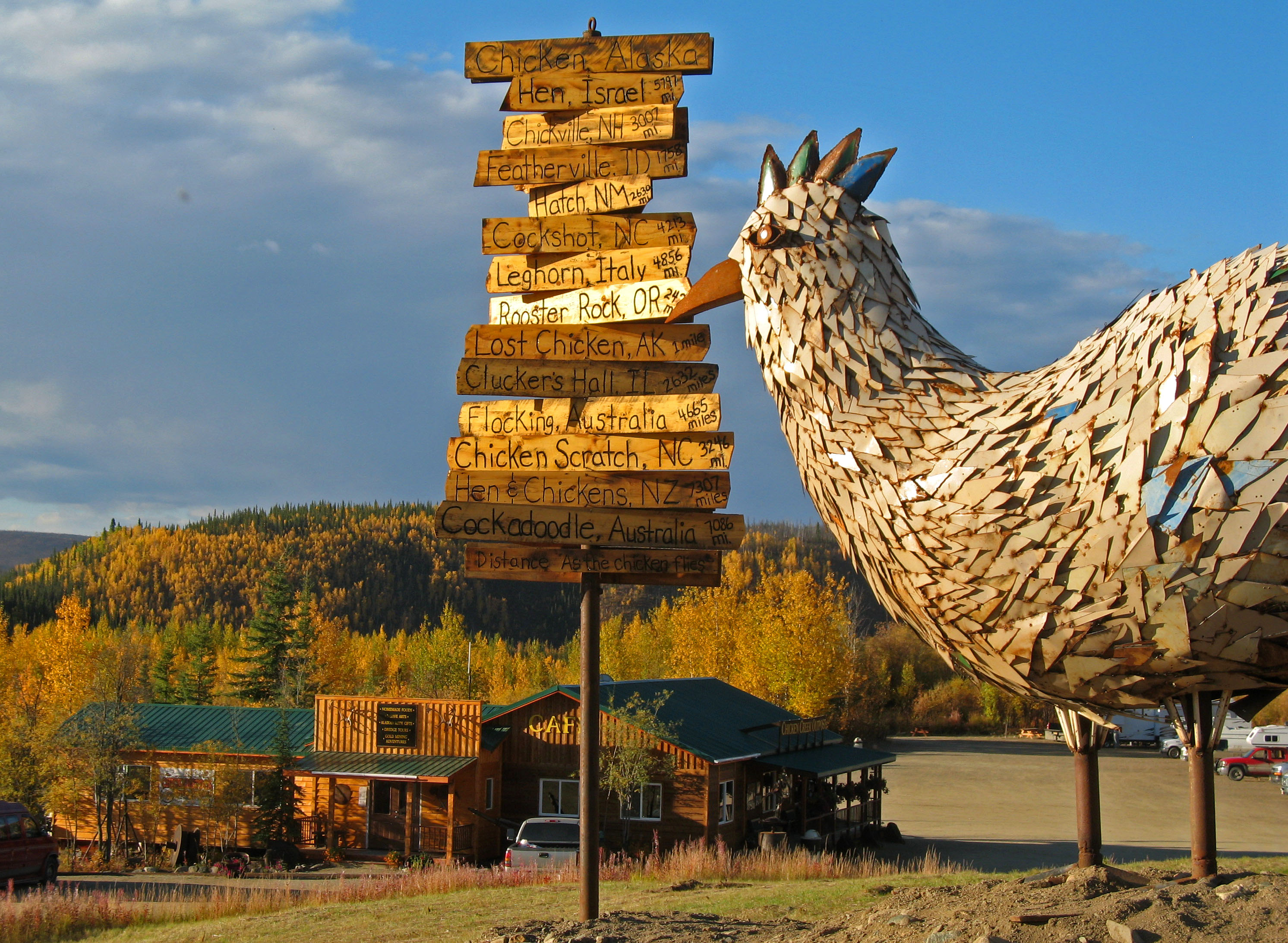 |
| Chicken; Photo: Explore Fairbanks |
It's famous for its locale – the first town you reach when crossing into Alaska from Dawson City, Yukon, on the Top of the World Highway.
 |
| We had to wait for the state to open because the time zone changes at the border |
Chicken is famous as one of the few surviving Gold Rush towns in the state (is 10-17 residents surviving?).
And, it's most famous for its name. Settled by gold miners in the late 19th century, when the town got a Post Office in 1902 it needed a community name. The residents decided to name it after the abundant Ptarmigan in the area. But, they couldn't agree on how to spell the tricky name. So, they picked a similar bird they could spell: Chicken.
 |
| Namesakes (Ptarmigan vs. Chicken) |
The town has a cafe with gas station, a small hotel, an RV park, a small general store and a saloon. I can't really recommend going there unless you're really into novelty. It's not all that quirky; nor is it particularly pretty.
 |
| Chicken, Alaska |
We went because we had read that the gravel Top of the World Highway was a spectacular alternative to the traditional paved last leg of the Alaska-Canada Highway (ALCAN) to the south. It was pretty, but many highways in Alaska and Canada are much more beautiful.
 |
| Pretty enough |
I can't really recommend it either, except for novelty. And, as a person who loves to stick pins in my Push Pin Travel Map, I like novelty.
Coldfoot/Wiseman
Coldfoot and Wiseman are two towns located along the Dalton Highway, which runs from north of Fairbanks all the way up to Deadhorse/Prudhoe Bay.

The road is primarily used as a haul road for the oil drilling business in Prudhoe, but, as a public highway, it can also be used for tourism.
Both towns are famous for being above the Arctic Circle and reachable by road.
Coldfoot is 254 miles north of Fairbanks and Wiseman is another 16 miles away (up the highway, over the river and then a bit south).
Wiseman, which is three miles from the Dalton Highway, was not connected to the road until the early 1990s.
We have been several times.
The first was a "Fly-over-the Arctic-Circle" tour, which lands at the gravel airstrip in Coldfoot and takes visitors by van to Wiseman to "experience a typical Alaskan town."
 |
| On our way |
When we signed up, I expected a native village, but Wiseman is not that. It, and nearby Coldfoot, started as mining towns, populated by White settlers. So, the "experience" is really just about remoteness (plus a snack).
 |
| Wiseman, winter and summer |
The other times we visited were overnight stays at the Arctic Getaway in Wiseman as part of Aurora Borealis photography tours (I went on one; Scott on two) and, once, Scott and Caty drove to Wiseman. The B&B's buildings include a former Pioneers of Alaska fraternal lodge building, Igloo #8, which harkens back to the days when settlers gathered together for dances and community socials. Arctic Getaway's proprietors, Berni and Uta Hicker, are German transplants and delightful hosts.
 |
| Left: our cabin; Right: Uta and Berni; Right photo: Arctic Getaway |
They can help arrange for lots of activities, including dog-sledding, flightseeing, snow-shoeing and wildlife viewing.
 |
| Mushing; Left: Berni; Right: Scott |
But, the best reason to visit is to view the spectacular aurora borealis (in the winter months, of course; it doesn't get dark in Wiseman in the summer).
 |
| Shooting the skies; Aurora photos: Scott Stevens |
Coldfoot, which is basically a truck stop midway up the Highway, allegedly got its name from travelers getting "cold feet" about making the 240-some-mile journey north to Deadhorse. It has a restaurant and a small number of overnight accommodations (converted pipeline construction camp quarters).
 |
| Coldfoot; Photo: Travel & Leisure |
The Coldfoot truck stop was founded by Iditarod champion Dick Mackey, who started his operation by selling hamburgers out of a converted school bus. Truckers helped build the existing truck stop and cafe.
Coldfoot could give Chicken a run for the money for size: the latest census showed 13 residents. By comparison, Wiseman is a bustling metropolis with more than 20 townsfolk.
 |
| Wiseman; Photo: Arctic Getaway |
Both towns have a subarctic climate. Summers are short and mild, with frequent rainy days and cool nights. It can reach the 80s, however.
 |
| Scott and me at the Arctic Circle |
Winters are long and severely cold, sometimes getting as cold as −74°F.
Annual snowfall averages 82 inches with a maximum monthly snowfall of 18.2 inches in February.
The drive is not for the faint of heart. The road is paved, but it makes the term remote seem superfluous. Anyone taking the trek should take plenty of food, water and emergency supplies. Be prepared to relieve yourself in the bushes; there aren't many facilities.
Also, be prepared (in winter) to get blasted with loud horns from truckers who don't take kindly to tourists.
 |
| The Dalton Highway serves the Alaska Pipeline, which is to the right of the road |
Dutch Harbor
If you're really adventurous, you might want to visit the Aleutians – the long chain of islands that extend to the southwest from Alaska.
 |
| Bald Eagles are common |
Because we had already traveled all of Alaska's connected roads and been to all its National Parks, I really wanted to see at least part of the Aleutians. We visited on a birding tours. I can whole-heartedly recommend High Lonesome BirdTours.
 |
| Black-footed Albatross! |
The trip was based in Dutch Harbor and included both birding on land and at sea. I am glad I chose this route. It was nice having all the arrangements made and having a guide. Plus, I am glad we birded because there is not all that much to do in Dutch Harbor.
 |
| It's a working town |
There is small museum, less than a day's worth of historic sightseeing and no large game to view, photograph or hunt (I don't hunt, but hunting does play into typical Alaska tourism).
 |
| The Red Fox is the only indigenous land mammal |
Fishing is an option, but the seas can be rough. Very rough.
The town has only 40 miles of road and most are steep and gravel.
 |
| Part of our birding route |
Located on Amaknak Island in Unalaska, Dutch Harbor has a number of protected bays that make it a natural port, protecting ships from the sometimes extreme waves and currents of the Bering Sea. Add to that that the ports are ice-free and the Aleutians are rich in both fish and crab and it is easy to see why the area was settled.
The culture of Dutch Harbor is a mix of the original Aleut inhabitants, Russians and the U.S. military.
 |
| Russian Orthodox Church (with an Eagle on the cross) |
Originally home to indigenous Aleuts, Dutch Harbor was settled by Russian trappers who came for Seal and Sea Otter fur. Of course, they massacred and enslaved the native population – well, at least the ones they didn't kill with disease. The United States bought Alaska in 1867, shortly before the fur trade slowed in the late 1800s as Sea Otters populations declined.
 |
| There are still Sea Otters around |
Then, prospectors came looking for gold, which amounted to nothing more than the harbor becoming a refueling port for steamers carrying prospectors in and gold out.
As the threat of war loomed in the early 1940s, the U.S. military took advantage of the excellent harbors and built a Navy base that could provide easier access to the South Pacific. In 1942, Dutch Harbor became one of the few sites in the U.S. to be subjected to aerial bombardment by a foreign power when it was attacked by the Japanese. By May 1943, a peak of 10,151 sailors and 9,976 soldiers were stationed there. But, the base was abandoned by the late 40s.
 |
| Reminders of the military past are everywhere |
Now, the area is famous for fishing and crabbing and has some of the largest seafood hauls in the world. The harbor is prominently featured in the Discovery Channel reality television series Deadliest Catch, which has originated from there since 2005.
 |
| Luckily, we didn't have this weather; Photo: Entertainment Weekly |
If you visit, realize that getting there is expensive; typical roundtrip air from Anchorage is $1,000 to $1,500 roundtrip. Passenger ferry is about $350 and takes about 27 hours. And, while it's in the same state, Dutch Harbor is 1,200 miles from Anchorage; the flight is longer than three hours.
 |
| And Dutch Harbor isn't even half-way down the Aleutian chain |
Also, be aware that the environment is harsh. Wind, rain, fog and high seas are common. I have heard horror stories of rough or aborted airplane landings, lost travel days waiting for fog to lift and horrendous ocean trips.
 |
| We had relatively mild weather with light rain, some sun and calm seas |
It is beautiful, with dramatic tundra-covered mountains, islands, bays ...
 |
| Rugged landscapes |
... and wildflowers ...
 |
| A pretty hillside |
Trees do not grow there naturally, although the town has a fair amount of planted Sitka spruce. As is common in Alaska, you certainly couldn't call the town pretty. It is a jumble of fishing/crabbing equipment, metal buildings, modest houses (with scrubby yards), some Russian relics ...
 |
| Typical remote Alaskan seafaring town |
... and some of the nicest playgrounds I have ever seen ...
 |
| Oddly, we saw no children |
The birds are incredible ...
 |
| And, some were Lifers! |
Especially seabirds ...
 |
| The Red-legged Kittiwake was a trophy bird |
 |
| The Whiskered Auklet was a main target |
 |
| More Puffins than I could imagine |
If you like Eagles, this is your place! We saw maybe 50 a day!
 |
| There are seven in that tree on the right |
Fairbanks
The second-largest city in Alaska, Fairbanks feels like a "real Alaska" small town. And, even with its ranking, it has only 32,000 city residents. Almost 100,000 people live in the North Star Borough (Alaska has boroughs rather than counties).
 |
| Downtown Fairbanks on a pretty day; Photo: Explore Fairbanks |
It was founded on 1901 as a trading post serving gold miners and it has a decidedly "gold rush" feel about it. It is also home of the University of Alaska and, as such, is an academic center. And, nearby Fort Wainwright Army Base and Eielson Air Force Base gives it a military flavor, as well.
 |
| Eielson AFB: Photo: Alaska's News Source |
It's in the interior, so it can be hot in the summer and very cold in the winter; it is the coldest large city in the U.S. The highest recorded temperature in Fairbanks was 99°F in 1919; the lowest was −66°F in 1934. It sits just 140 miles south of the Arctic Circle, so it has long days in summer and long nights in winter.
 |
| We flew to Anaktuvuk from Fairbanks |
It's a common disembarkation point for the Arctic bush.
At Fairbanks' founding, the only way to reach the city was via steamboat on the Chena River.
In 1904, Fairbanks got its first overland connection to the outside world, now the Richardson Highway (it was finally paved in 1957).
The city has a fair amount of fun things to do. At several places near town, you can see the Alaska Pipeline as it runs above ground (to protect the permafrost).
 |
| Snow doesn't last long on the pipeline; the moving oil heats it up |
You can take a paddlewheel boat tour of the Chena River on the Riverboat Discovery ...
 |
| The boat had lots of interesting stops ... |
 |
| ... a reconstructed Athabascan village ... |
 |
| ... with its own Reindeer herd ... |
 |
| ... a sled dog demo at Iditarod Champion Susan Butcher's Trail Breaker Kennels ... |
 |
| ... and a floatplane demonstration |
When we went, I feared it would be cheesy (I mean, it was packed with "cruise people"), but I actually enjoyed it.
Nearby Creamer's Field Migratory Waterfowl Refuge is a 2,200-acre bird sanctuary consisting of wetlands, fields and forests on a former farm.
 |
| Surplus grain from the dairy originally attracted birds; Photo: Friends of Creamer's Field |
More than 100 species, including Sandhill Cranes, Loons, Swans, Canada Geese, Plovers and Sandpipers have been seen there during spring and fall migrations.
 |
| Migrating Greater White-fronted Geese |
In the summer, there are lots of flightseeing trips that take you above the Arctic Circle (often after 9 p.m. so you can experience the "midnight sun").
 |
| Fairbanks Airport |
And, if you are lucky, you can catch the finals of the World Eskimo Indian Olympics, which is laid-back, fascinating and a real glimpse into indigenous cultures.
 |
| Miss WEIO finalists in native garb they made on a 90°F day! |
 |
| Photo: Alaska.org |
Fairbanks is just 128 miles north of Denali National Park and 80 miles south of the start of the Dalton Highway.
There are lots of mushers in Fairbanks (some people actually mush to work!), so, on a winter trip, you can go dogsledding. Plus, there is cross-country skiing and snowshoeing.
Don't miss the University of Alaska Museum of the North, with it exhibits about the history, people, animals, landscapes and art of Alaska. It is superb.
 |
| The gorgeous igloo-inspired Museum of the North building |
Exhibits include the mummified remains of a 36,000-year-old Alaska steppe bison that had been preserved in the Interior permafrost since the Ice Age, Alaska's largest public display of gold, outdoor sculptures and totem poles and the story of how earthquakes have affected life in Alaska.
Because Fairbanks has a much drier climate than coastal Alaska, it is probably one of the best places on Earth to catch the aurora borealis (AKA northern lights). I have written about aurora in Alaska before here and here.
Most hotels will give you a call if the lights start up in the middle of the night; all you have to do is ask.
 |
| Taken from a driveway in town in February |
There are also a number of accommodations just out of town that provide dark skies and viewing decks to facilitate sky watching.
 |
| The Aurora Borealis Lodge |
I have been to Fairbanks many times – winter and summer –and have found the people there to be among the friendliest I have ever met.
Just about 10 miles southeast of town on the Richardson Highway is the very kitschy town of North Pole, famous for its Santa Claus House gift shop. The shop has a huge collection of Christmas decorations, the world's largest fiberglass statue of Santa Claus and a small herd of domesticated Reindeer.
 |
| Tacky? Maybe! Photo: Explore Fairbanks |
Before Christmas each year, the Post Office in North Pole receives hundreds of thousands of letters to Santa Claus and thousands more from people wanting the town's postmark on their Christmas greeting cards to their families. The town advertises 99705 as the ZIP code of Santa. A community program also responds to letters addressed to 1 Santa Claus Lane.
 North Pole's Christmas-themed streets include Santa Claus Lane, St. Nicholas Drive, Snowman Lane and Kris Kringle Drive. Streetlights in the city are decorated in a candy cane motif and many local businesses have similar decorations. Firetrucks and ambulances are all red and the police cars are green and white.
 North Pole has an all-female flat-track Roller Derby league, the North Pole Babes in Toyland (NPBT), whose athletes have Christmas and North Pole-inspired Skater names.
And, yeah, I have been there and I have bought ornaments there.
Chena Hot Springs, about 60 miles east northeast of town, is a beautiful resort with hot springs and an ice museum.
 |
| Rustic charm |
The resort was founded in 1911 by two gold mining brothers, one of which was suffering from painful rheumatism.
It took the brothers a little over a month to reach the hot springs after searching for it in Interior Alaska's harsh landscape.
The current resort has 72 hotel rooms, eight dry cabins, an RV campground, yurts, a cafe and a restaurant.
 |
| The Chena Hot Springs restaurant |
Guests and non-guests can visit the big indoor pool and the outdoor wading lake, which are both constantly replenished with pungent (AKA smelly) mineral spring water that is about 165°F when it come out of the Earth. The pool is kept at 90°F and the outdoor lake at 106°F.
Aurora watching is a favorite activity at Chena Hot Springs.
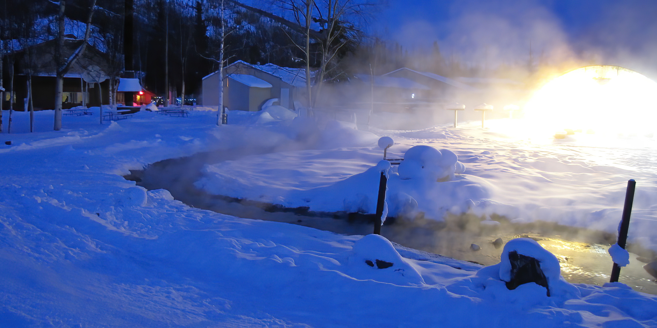 |
| On a cold night, you have to get away from the lake or steam will obscure your view |
The Resort's Aurora Ice Museum, a cool 25°F inside, features a wide array of ice sculptures, an Ice chapel, four hotel rooms inside the museum and an Ice Bar that serves appletinis in glasses made of ice.
 |
| The Aurora Ice Museum is the world's largest year-round ice environment |
Chena Hot Springs arranges for many activities, including dog-sledding and kennel tours, snowmobiling and ice fishing in winter and horseback rides, dog cart rides, kennel tours and ATV tours in summer.
There is also a retired Douglas DC-6 aircraft in the woods by the lodge.
 |
| It's strange to see it just sitting in the woods |
The Chena River, which runs through Fairbanks, freezes solid in the winter. In April and May, most of river ice thaws and breaks up into pieces. If everything melts too quickly, this can cause ice jams and catastrophic flooding to river communities. The phenomenon is called "break-up" and locals claim it is a time that everyone gets a little crazy (of course, the crazy could also be the result of having survived a long, dark winter).
 |
| Scott and his catch |
In addition, the Chena River State Recreation Area has ponds stocked with Rainbow Trout and Arctic Grayling. Scott has taken guided fishing trips there, while I birded.
 |
| I had more luck with Moose-ing |
Haines
A decidedly quirky small Alaska town, Haines rises dramatically up from the end of a narrow channel, providing the full transition from seashore to snow-capped mountains. It is in the northern part of the Alaska Panhandle, near Glacier Bay National Park and Preserve. It is flanked on both sides by channels, so a water/mountain view is ever-present.
 |
| A small town with big mountains |
Haines is relatively cut off from the rest of the world, including from Alaska. If you want to drive there, you have to leave the United States on the ALCAN, drive 288 miles through Canada, re-enter the U.S. and drive another 65 miles.
 |
| Border entry back to the U.S. |
But, in Alaskan terms, Haines is accessible. It is one of only three cities in southeast Alaska that can be reached by road from another city; the other two are Skagway and Hyder.
It's a gorgeous drive in the summer ...
 |
| Kluane Lake in the Yukon is on the route |
... but snow and ice conditions in the winter can be treacherous. Chilkat Pass, just north of the Canada-U.S. border, often closes in the winter.
It's actually easier to get to Haines on the Alaska Marine Highway (AKA ferry).
 |
| The ferry is the way to go! |
The Haines Airport has three bush carriers (Alaska Seaplanes, Wings of Alaska and Harris Aircraft Services) that provide service to Gustavus, Skagway, Sitka and Juneau.
Many people visit (briefly) via cruise ship, but without a car, you miss the best parts of town, which are just a bit too far for a stroll.
 |
| A pretty view outside of town |
The town itself, like so many in Alaska, is a bit scruffy.
 |
| Tlingits; Photo: Haines Sheldon Museum |
Haines has a varied history. It has been a Tlingit portage, a Presbyterian mission (it is named after a female missionary), a trading post, a center for disputes with Canada on where the Alaska/Canada border should be, a gold rush town, a center for fish processing, an Army base and an adventure sport capital.
With a population of only 2,500, it has limited services, which requires a certain level of resourcefulness from residents.
 |
| It's a small town |
For example, Whitehorse General Hospital in Whitehorse, Yukon, is the nearest hospital accessible by road and it's four and a half hours away.
Because of its proximity to the ocean, Haines has a much more hospitable climate that lots of Alaska.
 |
| Deep snow; Photo: Alaska Public Media |
Average January high and low temperatures are 30°F and 20°F, respectively.
Summers are cool to mild, with an average July high temperature of 65°F and an average low of 51°F.
But, it does snow there. Does it ever! In 2011−2012, Haines got 30 feet of snow!
The area is known for its Bald Eagles, especially in winter. Between October and February, the Alaska Chilkat Bald Eagle Preserve has the largest concentration of Bald Eagles in the world.
 |
| She owns the place |
While not as many live there in the summer, you will see (and hear) plenty.
 |
| Fighting over a fish |
Over Memorial Day weekend, Haines hosts the Great Alaska Craft Beer and Home Brew Festival. Alaska's longest running beer festival, the event showcases beers from 25 regional breweries in Alaska and the Yukon.
 |
| Rafting on the river |
The Davidson Glacier, due to its relatively accessible nature, is also a popular attraction.
Lutak Inlet and Chilkoot Lake are popular fishing sites. Lutak Inlet is frequented by Steller Sea Lions, Harbor Seals and Orcas.
 |
| Beautiful woods in the campground |
Fort William H. Seward is a National Historic Landmark, featuring well-preserved barracks, officer housing and parade grounds.
We stayed at Hotel Halsingland, which occupies former commanding and bachelor officers' quarters.
It was charming, but I greatly regretted not camping while in Haines because the both the nearby Chilkat State Park and Chilkoot Lake State Recreation Area campgrounds are gorgeous.
The woods, filled with pines and tundra, have a fairyland-like quality that just enthralls me.
 |
| I love these woods; Photo: Scott Stevens |
Haines is the location for the Southeast Alaskan State Fair, held annually each July. Among other attractions, the fairgrounds incorporate a portion of the set from Walt Disney's White Fang, filmed in Haines in 1990. The surviving set includes a dozen small structures common to a mining town of the period of Jack London's book of the same name.
You can learn a lot about Haines by reading Heather Lende's book, If You Lived Here, I'd Know Your Name, which really captures both the oddness and real danger of living in such a wild, remote place.
 |
| So lovely |
 |
| Proud of its position |
Homer
On the western tip of the Kenai Peninsula on the shore of Kachemak Bay sits the cute little town of Homer, 218 miles southwest of Anchorage.
Homer has lots of nicknames.
Long known as the "Halibut Fishing Capital of the World" (for obvious reasons), it is also called "the end of the road" and "land's end" because you just can't drive any further.
Only one road – the Sterling Highway – reaches the town despite its proximity (as the crow flies) to Seward and Kenai Fjords National Park. The mountains are just too rugged.
 |
| Homer from the air |
A narrow 4.5-mile-long gravel bar called Homer Spit extends from town into the Kachemak Bay. The spit houses Homer Harbor ...
 |
| The harbor |
... and a number of tourist-focused businesses, including shops, Halibut and Salmon fishing outfitters and guides, fly-in Bear viewing companies and kayaking outfitters.
 |
| It's a cute little area |
Much of the coastline, including the Homer Spit, sank dramatically during the Good Friday earthquake in 1964. Since then, very little vegetation grows on the Spit ...
 |
| Mainly gravel and sea grass |
... a big contrast to the lushness of the rest of town ...
 |
| Very green |
As with much of south-central Alaska, Homer has a moderate climate compared to interior Alaska. Winters are long, but not particularly cold, with the average January high only slightly below freezing. Annual snowfall averages 50 inches and annual rainfall is 25 inches. Summers are cool due to the marine influence, hovering around 55°F.
 |
| Some dramatic weather; Photo: Scott Stevens |
The population is 5,522.
Homer was named for Homer Pennock, a gold-mining company promoter, who arrived in 1896 and built living quarters for his crew of 50 men. But, gold mining was never profitable in the area. Coal was discovered in the 1890s and the Cook Inlet Coal Fields Company built a town, dock, coal mine and railroad. Coal mining in Homer continued until World War II. There are still 400 million tons of coal deposits.
 |
| Definitely a maritime town |
Another earlier settlement, Miller's Landing, was named after Charles Miller, who homesteaded in the area around 1915. An employee of the Alaska Railroad, he wintered company horses on the beach grasses on the Homer Spit. He built a landing site in a small bight in Kachemak Bay, where supply barges from Seldovia could land and offload their cargos.
There is abundant wildlife in the Homer area. The Alaska Maritime National Wildlife Refuge and the Kachemak Bay National Estuarine Research Reserve co-host a Visitor Center.
 |
| Gulls and Eagles are common along the Spit |

A special festival event is the Shorebirds Sing: Bird Call Contest, hosted by Homer Brewing Company (seems like lots of Alaska events are connected to beer!).
The lighthearted contest, which has attracted competitors as young as five (she learned bird calls from her grandmother), determines who can best mimic the calls of various bird species.
Homer is the southernmost town on the contiguous Alaska highway system and is also a port for the Alaska Marine Highway. The regional airport has local air taxis and regular scheduled commercial flights to Anchorage.
 |
| Homer erected its first traffic light in 2005 |

Tom Bodett, known for the Motel 6 "We'll leave the light on for you" ads is from Homer. He wrote a whimsical book, As Far as You Can go Without a Passport, about his hometown.
Singer Jewel grew up in Homer and many members of her family star in the reality show, Alaska: the Last Frontier, which has filmed on the family's homestead on Kachemak Bay since 2011.
Read the next post for more towns and villages (names starting with J through P).
No comments:
Post a Comment