 |
| The beautiful town of Petersburg |
Let's explore more cool places in Alaska: towns and villages starting with the letters J through P ...
Juneau
Juneau, the capital of Alaska, is unique because it cannot be reached by road.

Why no connecting roads? There are no places to put one. A route to the east intersects with an icefield the size of Rhode Island; a route northeast would be blocked by glaciers; and south is open water.
 |
| Taku Glacier from the air |
Plans to build roads to Haines and Skagway have been scrapped because of cost.
Juneau has local roads, but entry is via plane or boat and, for many, it is the beginning or end of an Alaskan cruise (especially the small boat cruises).
We have flown in (be aware fog delays are very, very common) and arrived via the Alaska Marine Highway. The ferry trip to Juneau is stunning.
 |
| I highly recommend taking the ferry if you have time (this is Eldred Light) |
The second-largest city by land area in the U.S., Juneau is rather small in terms of population, with only 32,000 people. In the summer, that swells by 6,000 people a day from visiting cruise ships.
 |
| A cruise ship in the harbor |
Located in the Gastineau Channel in the Alaskan panhandle, the city sits at the base of Mount Juneau across the channel from Douglas Island.
 |
| A view from Gastineau Peak |
The Juneau Icefield, a large ice mass from which about 30 glaciers flow, sits on top of the 3,000-to-4,000-foot mountains that surround the city. Two of the glaciers, Mendenhall and Lemon Creek, are visible from the local road system.
The city is named after a gold prospector from Quebec, Joe Juneau: it was once called Rockwell and then Harrisburg (after Juneau's co-prospector, Richard Harris).
 |
| Capitol building; Photo: SAH Archipedia |
Over the years there have been many attempts to relocate the capital. The proposals have failed because, although moving would ultimately save money, it would initially be expensive. Plus, well, politics.
 |
| Totem Pole Trail; Photo: TravelAwaits |
Russians never settled as far east as Juneau, although many Tlingits had adopted the Russian Orthodox religion, resulting in the construction of a Russian Orthodox church in Juneau in the late 1890s.
The first Europeans to see the area came with George Vancouver's 1791-95 expedition, but ice deterred them from landing.
The local gold rush began when namesake Joe Juneau and his partner Harris found nuggets "as large as peas and beans" at Snow Slide Gulch at the head of Gold Creek.
The resulting shanty town was the first American settlement founded in Alaska after it was purchased by the United States. It eventually became Juneau, which survived even after gold-mining petered out.
The city's climate is heavily influenced by the proximity of the Pacific Ocean and the warm Alaska Current. The mountains form a natural barrier for incoming air. These two factors create a mild and moist temperate rainforest climate, with little temperature variation.
 |
| Green and misty |
Winter averages range from slightly below to slightly above freezing; summers rarely get over 75°F. Precipitation falls on an average 230 days per year, averaging 62 inches, mostly in the fall and winter, with some falling as snow from November to March. Juneau does not have permafrost. The coldest temperature ever officially recorded in Juneau was −22°F in 1968 and 1972, while the hottest was 90°F in 1975.
 |
| Short sleeves in Alaska? Yes! |
In addition to government and tourism, fishing is a major part of the Juneau economy, but the town does comparatively little seafood processing compared to other towns of its size in Alaska. Instead, the fish goes to plants in Sitka, Hoonah, Petersburg and Ketchikan. In other words, the town smells better.
 So what is there to do there? It's a city, so there is city stuff like theater, symphony, opera, film festivals, art galleries and events associated with the University of Alaska Southeast Campus. The city hosts the Alaska Folk Festival and Juneau Jazz & Classics Music Festival each year and Celebration, a biennial Alaska Native cultural festival, every other year.
A city-owned ski resort, Eaglecrest, is located on Douglas Island. Nature-based activities include hiking (3.9 miles up and back) or taking the Goldbelt Tram up to Gastineau Peak for great views of the Gastineau Channel below.
 |
| Gastineau Channel |
I have gone Whale watching multiple in Juneau's Auke Bay.
 |
| I have consistently seen both Humpback Whales ... |
 |
| ... and Orcas |
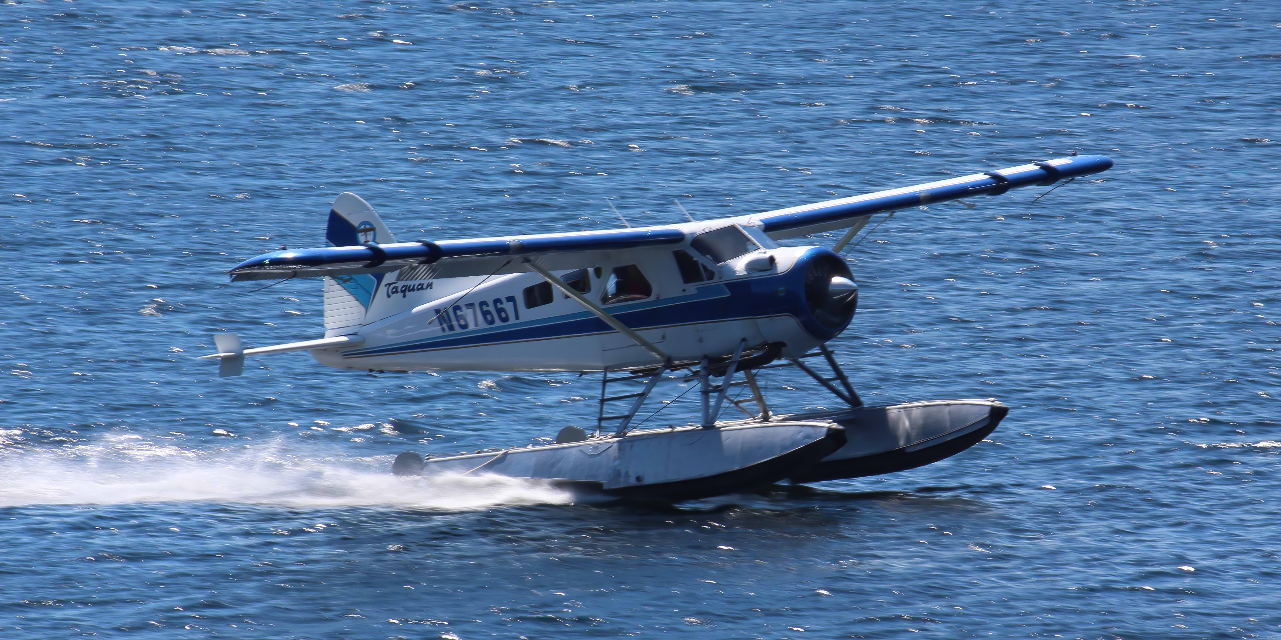
The gorgeous surrounding mountains, glaciers, channels, rivers and lakes make Juneau a great place for a flightseeing trip to see the glaciers.
 |
| Get under the wing |
If you go, pick a trip on a floatplane so that, in addition to seeing incredible scenery, you can experience landing on water. Once you do it, you'll be hooked.
And, make sure to check what type of plane you're flying on to ensure that you're looking at scenery, not a wing!
We love the Alaska State Museum, which has a fantastic collection of cultural materials from the Alaskan indigenous peoples: Tlingit, Haida and Tsimshian of the northwest coast; Athabascan of the interior; Inupiaq of the north coast; Yup'ik of the southwest; Alutiiq of Prince William Sound and Kodiak Island; and the Unangax from the Aleutians. It also covers the state's Russian colonial era, state and political history, fine art, natural history, industry and trades.
 |
| An ancient kayak |
As a cosmopolitan city, Juneau has lots of good restaurants.
One of the most popular things to do is to visit the beautiful Mendenhall Glacier Mendenhall Glacier, which is only 12 miles from downtown.
 |
| The Mendenhall Glacier |
The 13.6-mile-long glacier has retreated 1.75 miles since 1929, when Mendenhall Lake was created, and over 2.5 miles since 1500.
 |
| Me at the Mendenhall Glacier; Photo: Scott Stevens |
Although Mendenhall is expected to continue to retreat for the foreseeable future, it could briefly stabilize because Juneau is getting hotter. What??? Yep! Increasingly warm moist air carries up to the head of the icefield, where colder temperatures cause it to precipitate as snow. The snow feeds the icefield, possibly offsetting the continually increasing melting at the glacier's terminus. However, this phenomenon will fade if temperatures continue to climb, since the head of the glacier will no longer have enough cold to create snow.
Currently, Mendenhall terminates in a beautiful lake, but, eventually the glacier will pull out of the lake.
 |
| The icebergs are evidence of melting |
The lake, which formed in 1929, is a result of the run-off from the glacier and is increasing in size as the glacier continues to retreat. It is a nursery for a variety of fish including several type of Salmon, Dolly Varden, Char and Cutthroat Trout.
The Mendenhall Glacier Visitor Center, originally opened in 1962 and renovated in 1999, was the first U.S. Forest Service Visitor Center built in the nation. The Park has hiking trails and a very nice campground.
 |
| Scott relaxing |
Another fun place to go is Eagle Beach, where what we first thought were just stumps turned out to be about 150 Bald Eagles!
 |
| Eagles everywhere! |
 |
| Map: Planet Earth Adventures |
Kaktovik
If you want a truly unique Alaska experience, check out Kaktovik (well, check it out someday when you are allowed in).
This tiny Inupiat village is at the very top of Alaska on the north shore of Barter Island on the Beaufort Sea coast. It's near, but not connected by road to, Deadhorse and the Prudhoe Bay oil fields and the 19.6-million-acre Arctic National Wildlife Refuge.
Why would you go? One simple reason: Polar Bears.
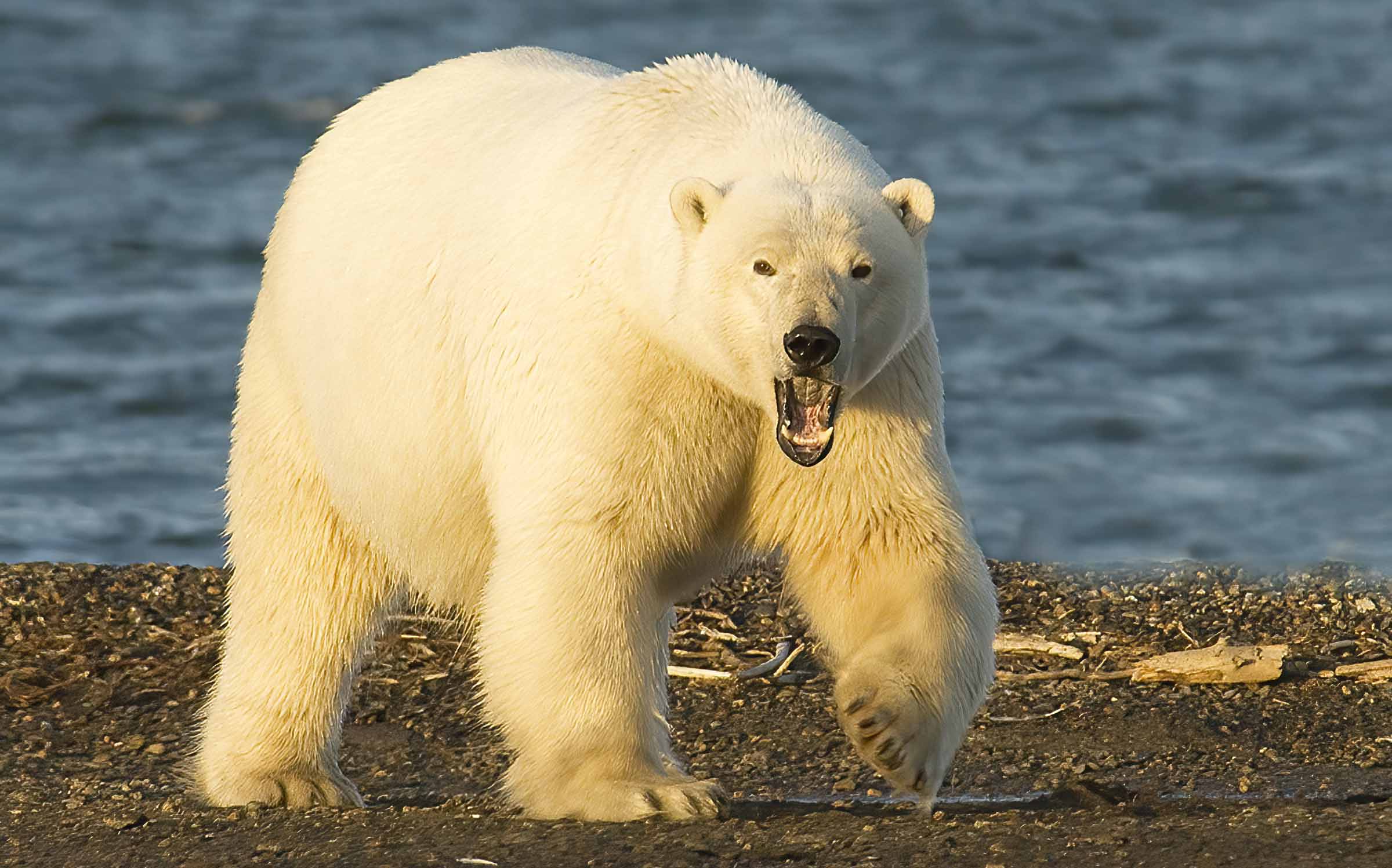 |
| One of nature's most magnificent beasts; Photo: Scott Stevens |
Every autumn, Polar Bears gather along barrier islands just off Barter Island as they wait for the Beaufort Sea to freeze so they can head out onto the sea ice to hunt their favorite prey, the Ringed Seal.
During late September and early October, Kaktovik is the best place in the U.S. to see the highly endangered Polar Bear.
 |
| Polar Bear near town; Photo: Scott Stevens |
They normally hang out on a spit about a mile away from town, but they often swim over in the late afternoon ...
 |
| Swimming in an icy sea; Photo: Scott Stevens |
... to feed at the "boneyard," an area where the local villagers dispose of the remain of Whale harvests.
 |
| At the boneyard on a snowy day; Photo: Scott Stevens |
Native Alaskans are still permitted to hunt Whale – a favorite food – under very strictly enforced mandates. The rule gives every Inupiat village a number of Whale "strikes" based on population. With a Native population of about 212 (of a total of 238 people), Kaktovik gets three strikes.
 |
| We witnessed a Whale harvest |
That means that they can make three attempts to bring in a Whale. An attempt is a harpoon throw. If they go out on a hunt and the harpoon doesn’t bring in a Whale, it still counts as a strike.
When they do get a Whale, they butcher it and distribute the meat and blubber equally among the villagers. The scant remains are then dumped at the boneyard on a finger of land away from town.
 |
| A common Alaskan sight: modern equipment accomplishing an ancient tradition |
The Bears then come and clean up whatever is left.
 |
| Enjoying fresh Bowhead Whale |
There are a number of tour operators that conduct both van and boat trips to see the Bears. Scott first went as part of his aurora borealis photo tour and then he and I went back by ourselves. We stayed at the rustic (and I really mean it this time) Waldo Arms and rented a dilapidated truck to drive to the boneyard. The Waldo Arms also takes guests on an old school bus to see the Bears.
 |
| Off to the boneyard to see Polar Bears |
The Waldo Arms is a very Alaskan experience. It is housed in trailers that were originally set up in 1978 as a bunkhouse for Alyeska oil pipeline workers. It ain't fancy (I really mean that) and it is really expensive (over $500 a night per person during Polar Bear season). Warning: the Waldo Arms' website is much nicer than the actual hotel.
 |
| You're not visiting for the ambiance: Middle and lower left photos: TripAdvisor |
The food is surprisingly good (breakfast, lunch and dinner are included in the per-person rates) and, well, Polar Bears! What more can I say.
There are at least two other hotels in town – the Marsh Creek Inn and Caribou Cabins – which look a bit more civilized, but I haven't stayed there.
 |
| Dirty face; Photo: Scott Stevens |
Note: The Arctic National Wildlife Refuge has not issued permits to Polar Bear viewing tours and the town of Kaktovik has been closed to non-essential travelers since the pandemic in 2020. So far, they have given no indication when the town will reopen and tours will resume, but many outfitters are hoping for 2024.
The Inupiat are very protective of the area and their rights to it. Until the late nineteenth century, Barter Island was a major trade center for them. It was especially important as a bartering place for Inupiat from Alaska and Inuit from Canada (hence the island's name).
Kaktovik was a traditional fishing place with a large pond of good fresh water on high ground with no permanent settlers.
 |
| Barter Island |
This changed when the United States built a Distant Early Warning Line radar station in Kaktovik in the 1950s, which necessitated construction of a small airfield. This ended the village's complete isolation. It can be reached only by air and (for supplies) barges in the summer.
The community that formed in Kaktovik has maintained Inupiat Eskimo traditions, including relying on subsistence hunting of Caribou and Whale.
 |
| They can still hunt Polar Bears, but realize their fragile status |
At 220 miles north of the Arctic Circle, Kaktovik has long, very cold and very dark winters. The sun does not rise above the horizon for about two months, leaving only a dim twilight as the source of light during mid-winter. And, average high temperatures range from -1°F to -5°F from December to March (the lows are about ten degrees colder). Summers, on the other hand, are cool, ranging from the 30s to the 50s. The sun does not set for a few weeks every summer.
 |
| October sunset |
When we were there, we got to see a phenomenon called the "fata morgana," which is a type of mirage visible in a narrow band right above the horizon. The term is Italian for Morgan le Fay of Arthurian legend, because these mirages are often seen in the Italian Strait of Messina and were described as fairy castles in the air or false land conjured by Morgan's magic.
 |
| A very strange phenomenon |
Common in Polar regions, the mirage comprises several inverted (upside down) and erect (right-side up) images that are stacked on top of one another. Fata Morgana mirages also show alternating compressed and stretched zones. This optical phenomenon occurs as rays of light bend as they pass through a layer of significantly warmer air resting over colder dense air, forming an atmospheric duct that acts like a refracting lens.
 |
| Beautiful Bear; Photo: Scott Stevens |
Traveling to Kaktovik to see Polar Bears is a bit tricky to combine with other Alaska travel because the Bears are there when almost everything else in Alaska is shutting down for the season. You can squeeze it in if you do a final cruise of the season and then fly up to Kaktovik.
As with the rest of Alaska, weather is a major factor. It is very possible to get fogged out or fogged in, so add some free days at both ends of your visit.
It is possible to plan perfectly and completely miss the Bears if the ice sets up early. On our visit, we met people who had traveled from Norway for a second try after missing the Bears the year before.
Kenai/Soldotna
We are "nature" people, not "town" people, so we don't usually pay a lot of attention to cities (except the good ones). Still, I need to cover all the ones I have visited in Alaska.
 |
| Map: Google Maps |
Kenai and Soldotna sit ten miles from each other on the west side of the Kenai Peninsula.
Together, they form a unit with almost half of the Peninsula's population of 53,000.
I've been through both multiple times, stayed in them a few times and don't have a strong opinion except that they're fine places to get gas, buy groceries, eat, sleep, depart for somewhere really cool ..
 |
| Taking off from Soldotna for Lake Clark National Park |
... oh, and get medical attention ...
 |
| It is a fishing town |
Kenai is named after the local Dena'ina word "ken" or "kena'," which means "meadow" or "open area with few trees." With its location at the mouth of the Kenai River, this is an accurate description.
Soldotna is a bit further inland on a bend in the river and on the western edge of the vast Kenai National Wildlife Refuge, a protected area spanning nearly 2 million acres and home to Bears, Moose, Caribou, Dall Sheep and many fish and bird species. I will talk more about the NWR in another post.
 |
| Sometimes animals are in town; this Moose was on a street corner in Soldotna |
I always thought the name Soldotna sounded Russian and it might be. It could have originated from the Russian word for soldier. But, it could also come from the Athabascan word for stream fork. No one knows.
The area was occupied by the Kachemak people for about 2,000 years until they were displaced by the Dena'ina Athabaskan people around 1000 A.D. When Russian fur traders arrived in 1741, about 1,000 Dena'ina lived in the area. The traders called them "Kenaitze" or "Kenai people," meaning "people of the flats."
 |
| The flat land around the Kenai River |
The traders built Fort St. Nicholas, the first European settlement on the Alaskan mainland, in 1786. After 11 years of tolerating the invaders, the Dena'ina attacked the fort in a battle where more than 100 people died. In 1838, smallpox killed half of the native population.
Even though Alaska was American, the Russia influence continued, especially in terms of religion.
 |
| Holy Assumption of the Virgin Mary Russian Orthodox Church in Kenai |
From the 1900s to the 1920s, commercial fishing, canning and shipping ruled the area and, in 1940, Kenai and Soldotna were opened to homesteading.
All this happened without roads; the first road from Anchorage wasn't constructed until 1950. The Kenai Spur Highway, which branches off the Sterling Highway in Soldotna and goes to Kenai, opened in 1956.
 |
| Scott photographing Alaskan lupine on the Sterling Highway |
In 1957, the first major oil discovery in Alaska was made at Swanson River, 20 miles northeast of Kenai. In 1965, offshore oil was discovered.
 |
| Oil rigs in Cook Inlet |
Although many fishing boats are based in Kenai, the city does not have a formal port and harbor. There are docks for offloading the catch, but commercial fishing boats are generally moored offshore in the Kenai River. The nearest deep-water port is in Nikiski, which is primarily reserved for the oil and gas industry.
 |
| Nikiski oil refinery |
The fishing that rules Kenai and Soldotna, however, is Salmon fishing on the Kenai River. Eight of the ten largest King Salmon caught in the world have come from the Kenai, including one that weighed more than 97 lbs.
 |
| Fishing season on the Kenai |
Old Town Kenai is home to a collection of historical buildings. The Kenai Visitor and Cultural Center has historical exhibits highlighting the city's Russian heritage, offshore drilling, natural history and Alaska Native artwork.
Located near the Soldotna Visitor Center is the Homestead Museum, a collection of early structures and Alaska Native artifacts.
And, while people tend to think of northern Alaska for aurora borealis, one of the best displays I ever saw as in Soldotna.
 |
| Wow! Just wow! |
Ketchikan
Ketchikan, the southernmost city in Alaska and the gateway to the Inside Passage, is the sixth-most populous city in the state with just over 8,000 residents (14,000 if you include neighboring areas).
 |
| Ketchikan on a (rare) sunny day |
Located on Revillagigedo Island, Ketchikan is named after Ketchikan Creek, which flows right through the town, emptying into the Tongass Narrows a short distance southeast of downtown. During Salmon runs, you can stand in the middle of town and watch hundreds of the fish battle their way upstream.
 |
| Ketchikan Creek is great salmon viewing spot |
Ketchikan Creek served as a summer fish camp for the Tlingit for years before the town was established in 1885 as the site for a cannery.
The town is steep – very steep – with most of the developed area just a few city blocks from the waterfront. Elevations of inhabited areas range from just above sea level to about 300 feet. Deer Mountain, a 3,001-foot peak, rises immediately east of the city's downtown area.
 |
| It's so steep, the town has a funicular, right |
Ketchikan is surrounded by the Tongass National Forest and, to the south, by the Tongass Narrows, a narrow east-west saltwater channel, which is part of the Inside Passage.
 |
| Floatplane taking off from the channel |
The half-mile wide Narrows separate Ketchikan from Gravina Island, where Ketchikan International Airport is located.
Ketchikan has the world's largest collection of standing totem poles, found throughout the city and at four major locations: Saxman Totem Park, Totem Bight State Park, Potlatch Park and the Totem Heritage Center. The Totem Heritage Center displays preserved 19th-century poles rescued from abandoned village sites near Ketchikan.
 |
| Most are re-carvings of older poles done by the Civilian Conservation Corps |
Ketchikan is the third-wettest city in the United States after Whittier and Yakutat, with 149.54 inches a year. I have been there on a sunny day, but it rains about 111 days a year. Winters are chilly but milder than its latitude alone may suggest: January has an average daytime high of 40°F and an overnight low of 31.5°F.; August daytime highs average 65°F and overnight lows average 53°F.
 |
| It is very damp; moss grows on everything |
A major and first port of entry into Alaska, Ketchikan's economy is based on fishing, canneries, tourism, government and forestry. About 40 different cruise ships together make more than 500 stops in the harbor each year, bringing more than a million visitors to Ketchikan.
 |
| Cruise ships in the harbor |
 |
| Scott exploring town |
As a result, the city is horrendous when the ships are in (you know it's bad when you have to step over vomit twice in 10 minutes).
When the ships are gone, its a lovely little town.
But, be aware that the cruise lines own most of the stores on the main drag, so it isn't very authentic.
Ketchikan receives service from two separate Alaska Marine Highway System ferry routes.
 |
| View from the ferry |
The Inside Passage route travels northbound to Alaskan ports and southbound to Prince Rupert, British Columbia, where a connection can be made to BC Ferries to Bellingham, Washington. Regular day service shuttles between Metlakatla and Ketchikan.
 |
| Ketchikan celebrating its wildlife |
Nearby Misty Fjords (also sometimes spelled Fiords) National Monument is one of the area's major attractions. I'll talk about it later.
Metlakatla
You probably wouldn't go to Metlakatla unless your cruise ship stops here, but it's pretty interesting.
 |
| Metlakatla; Left photo: Accent Alaska; Right photo: TravelAlaska |
It is a Tsimshian settlement with about 1,500 inhabitants. In a more ancient time, it was a Tlingit hunting ground known as Taquan. The Tlingit gave the land to the Tsimshian ages ago.
 |
| Tsimshian Community House; Photo: Alaska Marine Highway |
The current town, of course, was created with intervention from White people. In 1886, William Duncan, an English tannery employee and lay minister of the Anglican Church in another village of the same name in British Columbia, had a theological dispute with the Church authorities, so he and a group of Tsimshian followers asked the U.S. government to give them land in Alaska.
 |
| The two Metlakatlas; Map: Anchorage Daily News |
 |
| A little dancer |
The residents voted to opt out of the Alaska Native Claims Settlement Act of the 1970s in order to retain rights to their land and waters.
Membership in the community is by lineage; it consists primarily of Tsimshian people and other Alaskan Native peoples who have been granted approval by the Metlakatla Tribal Council and Executives to join the Community as "bona fide members."
When we visited, we saw local dancers (including very little ones) perform in a large community house.
A Coast Guard search and rescue base on the island was originally a military base used by both the U.S. and Canada to protect the continent during World War II. Construction of the base included building a road connecting the ocean-side city to Alaska's Inside Passage and an airfield on Annette Island that was garrisoned by Canadians during the war. The airfield served the area commercially until the 1970s, when the new Ketchikan Airport was built. Now access is via cruise ship, the Alaska Marine Highway or seaplane.
 |
| Metlakatla; Photo: Alaska Marine Highway |
Due to its southerly and maritime location, Metlakatla is one of the warmest locations in Alaska. During summer, there is an average of 23 days with 70°F+ highs. Precipitation averages more than 101 inches annually, with June and July being the driest months and October and November the wettest.
Most stops on the island are relatively short because there isn't much to do. Visitors can attend song and dance performances by local Tsimshian dancers at the community longhouse facing the boat harbor. You can visit (and shop at) the community art center and see local totem poles.
 |
| Cool local art |
Metlakatla has two small hotels and a handful of restaurants and markets. Visitors who want to spend more than 24 hours in the village must apply for a visitor permit.
Nome
Far better known, but still somewhat "out of the way," is Nome, which is reachable only by air and an occasional cruise. We visited with Nome Discovery Tours, which included round-trip air, guided tours, an overnight stay and a rental car for the second day. You can also do a same-day fly-up-and-back, but we wanted time to explore on our own.
 |
| A funky little town |
A big reason to visit Nome is that it is probably the easiest place to see wild Muskoxen (Umingmak in Inuktitut).
 |
| We saw a small herd (about a dozen) right in town when we went |
Several places in town even warned about their aggressive nature, urging caution in parking lots.
 |
| That fur keeps them warm |
Although all the ones we saw were placid and slow-moving, a Muskox can reach speeds of almost 40 mph.
 |
| There are not many places where you can see this |
 The town of Nome sits at the tip of the Seward Peninsula on the Bering Sea (not to be confused with the more southerly Kenai Peninsula where the town of Seward is located).
 From prehistoric times, Inupiat hunted for game in the area. They had a settlement called Sitnasuak there before the arrival of White men.
On a wide expanse of rolling tundra, clear rivers, expansive marshes and wide sandy beaches, it has few trees. We went in early fall, where everything was a brilliant orange.
 |
| Stunning |
Allegedly the town's name came from a map that labeled the point upon which it sits as "No Name." Like so much you hear in Alaska, that may or may not be true.
Nome's population has fluctuated wildly. It now has about 4,000 residents, but has been as high as 20,000 and as low as 850. That's what gold will do to a town.
 |
| Parts seem like a ghost town |
In the summer of 1898, gold was discovered on Anvil Creek and, within a year, the area was organized as a mining district. Then, gold was found in the coastal sand, spurring an even bigger gold rush. About 1,000 prospectors a day came by steamship from Seattle and San Francisco and built a tent city. It was the last great gold stampede in the history of the American West.
By 1910, most of the mines were depleted and the rush was over. Fires in 1905 and 1934 and violent storms in 1900, 1913, 1945 and 1974 destroyed much of Nome's gold-rush-era architecture. Nome is dotted with abandoned gold dredges. These are large, multi-story machines that use water to extract gold from sand, gravel and dirt. Most of the ones in Nome were built in the 1900s, but there are some newer ones that are still working.
 |
| Abandoned gold dredge |
In addition to gold, Nome is famous for the1925 "serum run," when a relay of dogsled teams delivered life-saving diphtheria medication to Alaska natives in a blizzard. In 1973, Nome became the ending point of the 1,049-mile Iditarod Trail Sled Dog Race; using the same route for the end as the serum run.
Nome's climate is subarctic, with long, very cold winters and short, cool summers. Moderated by the coastal location, winters are less severe than in the Interior, and conversely, summers are lukewarm. With only 81 days without freezing temperatures, January averages 5.6°F and July averages 52°F.
 |
| Coastline |
Nome is a small town that is a bit nicer than the other remote villages I have visited. It has an airport, schools, churches and lots of saloons. The population is a mixture of Inupiat and non-natives. Among the Inupiat, subsistence hunting and fishing are prevalent.
 |
| Fishing shacks |
Nome has 350 miles of roads but is not connected by land to any of Alaska's major cities. Three roads head out of town and Scott and I explored two of them.
 |
| Exploring |
Teller Road travels 70 miles northwest to the town of Teller on the southern half of the spit called Nook (or Nooke), where the Inupiat had a fishing camp in the early 19th century.
In the late 1800s, the United States introduced Reindeer herding in Alaska, creating the Teller Reindeer Station that operated from 1892 to 1900. The station was named for Senator and Secretary of the Interior Henry Moore Teller.
 |
| An old graveyard |
There are allegedly still Reindeer in the area, but we saw none.
The town of Teller was established in 1900 after the Bluestone Placer Mine discovery 16 miles to the south. During the boom, Teller had a population of about 5,000 and was a major regional trading center.
 |
| Teller Road |
Today, Teller is an Inupiat village with about 200 residents that depend primarily on subsistence hunting and fishing.
Teller Road is a virtual museum of tundra vegetation including dwarf shrubs, sedges, grasses, mosses and lichens. The word "tundra" refers to areas where the subsoil is permafrost, frozen 10 to 35 inches down, making it impossible for trees to grow. In summer, permafrost thaws just enough to let plants grow and reproduce.
 |
| Lots of tundra plants and berries |
Nome-Council Road, which travels east flanked by the ocean on one side and Safety Sound on the other, curves to the northeast toward the abandoned town of Council on the Niukluk River.
Built in 1897-98 when gold was discovered near Ophir Creek, Council may have had as many as 15,000 inhabitants during the early years. But, they soon left to work larger gold discoveries near Nome around 1900. During the summer, Council is a fish camp and a recreational area for locals. The "town" has no official residents today.
 |
| Nome-Council Road just out of town |
Nome-Council Road is closed during winter. But, because it is the nearest site with trees, some Nome residents travel there in winter to cut spruce Christmas trees.
The "Train to Nowhere" sits about halfway along Nome-Council road in the middle of a marsh.
 |
| Me at the train display; Photo: Scott Stevens |
Investors from Chicago had planned to connect Nome to mines in Council via a railroad that would eventually go all the way south to Vancouver, British Columbia, in Canada. In 1903-1904, steamers from Seattle delivered three retired New York locomotives, box cars, flat cars, 51 miles of track, railroad ties and lumber for trestles, offices, housing and a machine shop.
 |
| The trains were built in the late 1800s |
Workers completed about 10 miles of main line and laid out a town site that soon had five saloons, six restaurants and other businesses. But, when the gold boom busted in 1906, construction stopped with only 35 miles of track in place. A storm then toppled some of the cars and washed out the track. Now there are only the rusting locomotives and scattered equipment.
 |
| Abandoned equipment |
Along the road, if you look really hard, you can see the barest outlines of ancient Inupiat mound dwellings, which pre-dated the gold prospectors by many years. Inuit people lived in thie region as an identifiable culture for at least 4,000 years; the earliest documented evidence of human habitation dates back 10,000 years.
 |
| Ancient history |
A fun stop on the road is the Safety Roadhouse, a rustic tavern that is open in the summer and then again for several weeks in March, when it serves as the final checkpoint for the Iditarod Trail Sled Dog Race. It's one of those funky places adorned with dollar bills and garage-sale furniture.
 |
| The Safety Roadhouse; Top left photo: Scott Stevens |
Palmer (an hour north of Anchorage) is more of an Anchorage suburb than a tourist destination. But, it does have a few nuggets to offer. The ninth largest city in Alaska, it has 5,888 residents.
Sitting on the Glenn Highway in the Matanuska Valley, Palmer lies on the north shore of the Matanuska River, not far above tidewater, between the Talkeetna Mountains to the north and the Chugach Mountains to the south and east. Pioneer Peak rises over 6,000 feet.
 |
| Palmer is suburban and agricultural; Photo: Alaska.org |
The first inhabitants were Dena'ina and Ahtna Athabaskans who lived a subsistence lifestyle and traded with other native groups along the Matanuska River. The town grew out of a trading post established in the early 1890s by entrepreneur George W. Palmer.
In the early 20th century, the Alaska Central Railroad was constructed to transport coal from north of Palmer to fuel World War I battleships. At the end of the war, the Navy distributed land in the coal fields to war veterans and the U.S. opened additional land to homesteading, attracting farmers and miners and to the area.
 |
| Palmer Depot, 1975; Photo: Art Gibson, Alaska Railroad Photographs |
With its rich soil and long summer days, Palmer became a productive agricultural area. It attracted midwestern farmers from Minnesota, Wisconsin and Michigan who based town design on cities in their home states.
Construction of the statewide road system and the rapid development of Anchorage fueled more growth. Now, many Palmer residents commute 45 minutes to work in Anchorage.
Palmer is most noted in Alaska as the location of the annual Alaska State Fair, which, in turn, is famous for its contests for largest vegetable in several categories. Many national and even world records have been recorded at the Fair, with the cabbage, radish, spinach and lettuce categories usually dominating local interest.
 |
| The Alaska State Fair |
The Fair is delightful, primarily because it is still relatively small, it benefits from Alaska's abundant summer daylight (but gets enough dark for fireworks) and it is much cooler than many state fairs in the lower 48.
Palmer is also home to the Musk Ox Farm, where the proprietors are undergoing the slow process of domesticating these rather ferocious beasts for the qiviut trade. Qiviut is a very soft, very warm wool made from Musk Ox hair.
 |
| A shedding Muskox and wool; Right photo: Musk Ox Farm |
There have been at least two domestication attempts. In the 1950s, an American researcher and adventurer captured Muskox calves in Northern Canada for relocation to Vermont, where they grew up but were plagued by parasites and diseases.
 |
| In the pasture |
The surviving herd was eventually relocated to a farm in Palmer, which became the Musk Ox Farm in the mid-1950s. Currently, they harvest the shed qiviut from bushes and twigs because domestication has not progressed to the point where you could get close enough to a Muskox to comb the fur out.
 |
| Still wild |
You can visit the Farm and buy lovely qiviut items in the store there. According to the Farm, it takes about 200 years to domesticate a species. In the meantime, they even have their own Running with the Bulls!
 |
| Right middle: Running with the Bulls; Right bottom: Mat-Su Valley |
Palmer has a log cabin Visitor Information Center in the heart of downtown that features two acres of public gardens showcasing more than 600 locally grown plant varieties. The Palmer Museum of History and Art, located in the Visitor Information Center, displays artifacts from Palmer's history.
Petersburg
Petersburg is a lovely town on the north end of Mitkof Island where the Wrangell Narrows meet Frederick Sound. It is halfway between Juneau, 120 miles to the north, and Ketchikan, 110 miles to the south.
 |
| The prettiest waterfront I have ever seen |
Mitkof Island is covered by low mountains and muskeg, a type of soil made up of plants in various states of decomposition. It is approximately 20 miles from its north end to its south. The Wrangell Narrows provide a somewhat protected waterway for boats.
 |
| Photo: Little Norway Festival |
Founded by Norwegian immigrants, Petersburg is known for its strong Norwegian traditions and is nicknamed "Little Norway."
Petersburg even celebrates Norwegian Constitution Day with the "Little Norway Festival" over the third weekend in May.
The event is longer and more enthusiastic than any other known Norwegian-American Norwegian Constitution Day celebration and, indeed, is bigger than celebrations in Norway.
With abundant fish in the area, indigenous people have fished the area for 10,000 years.
 |
| A stream enters the bay |
The original Norwegian settlement built a sawmill, docks and cannery. Icebergs from the nearby LeConte Glacier provided a source for cooling fish.
 |
| Nature's icemaker |
The town now has four canneries, multiple fisheries and a number of sportfishing outfitters.
 |
| Petersburg smells a bit like cat food due to its profitable Salmon-canning business |
The main producers are 58-foot "seiners'" that harvest Salmon, Halibut, Black Cod, King Crab, Tanner Crab and Herring, often traveling to the western Gulf of Alaska and the Bering Sea. Petersburg also maintains a large contingent of Bristol Bay fishermen, with more than 75 residents who travel each summer to fish commercially on around 35 Bristol Bay vessels in Naknek, Dillingham and King Salmon.
According to the National Marine Fisheries Service, the town is the 15th-most lucrative fisheries port in the United States by volume. As a result, the town has high median incomes and an exceptionally high standard of living.
 |
| A beautiful town |
The population was 3,043 at the 2020 census,
Located on an island with no bridges to the mainland, Petersburg can be accessed only by air or sea.
Because most tourists arrive by small cruise ships, the Alaska Marine Highway and private yachts, Petersburg has a high-quality visitor experience without the crowds experienced by the neighboring communities of Juneau, Sitka and Ketchikan. This is partially by design and partially a result of the difficulty of landing large ships in Petersburg and traveling through the treacherous waters south of town at the Wrangell Narrows.
 |
| Dramatic landscape |
Alaska Airlines serves Petersburg with both cargo and passenger service from Wrangell and Juneau, with service ultimately reaching Anchorage and Seattle.
The Petersburg Marine Mammal Center provides education on marine mammals and supports research into new discoveries. A member of NOAA's Alaska Marine Mammal Stranding Network, it has a team of volunteers trained to assist distressed Whales and marine mammals.
 |
| Humpback Whales |
Petersburg's Clausen Memorial Museum is dedicated to preserving the history and telling the story of those who have lived and worked in Petersburg and the surrounding area.
Read the next post for the rest of the towns and villages I am covering.
No comments:
Post a Comment