|
| On the road again |
Whittier
Getting to Whittier is interesting. You have to drive through a railroad tunnel. It has passages to Whittier every hour. Then, there are passages from Whittier.
 |
| Approaching the tunnel |
And, the rest of the time the train goes through. Before the opened the tunnel to cars, you could reach Whittier only by rail or boat.
The weather was incredibly gloomy – gray, drizzly and foggy. In other words, typical Alaska weather we hadn't seen yet. The ferry office was very specific about what time you could check in. NOT BEFORE 12:30!!!! And there was no place nearby to park the car and trailer. But, we parked and walked.
Cruising
The trip was quite different from the one we took in 2001. That day was sunny and magnificent. the water was deep blue and the scenery was fabulous.
This journey was beautiful, but in a moody, drippy sort of way.
Valdez and the Richardson Highway
We walked to a pizza joint and watched firsthand how lack of available workers makes it really hard to provide customer service. At least we got our food; they turned away most walk-ins and callers.
Then, to bed...
Then through Keystone Canyon and up to the Worthington Glacier (billed as the most accessible glacier in Alaska). What a shock!!! In 2001, we walked up to the face and climbed on the glacier. Now, it's a hanging glacier way back from the viewing platform. It's a shocking trend to see these glaciers recede so much on our life times.
Wrangell-St. Elias
It's an interesting National Park Road because most of it it is not actually on Park land. It cuts in and out of private property. And interesting feature at the beginning is fishwheels that the indigenous people use to catch salmon on Copper River.
The now abandoned mine (and town) were built in 1900 and operated until 1938, pulling about $300 million in copper and silver before the mine closed. It was reached by rail (now the road) and was a vibrant town. The defunct mine building is being restored. It is 14 stories tall.
Oh, by the way, the warm weather and an earlier rain storm had caused a flood! It made crossing the footbridge scary!
Although Wrangell-St. Elias is the largest National Park in the system (more than 20,000 square miles or more than twice the size of the state of Maryland), it is also barely accessible with only two short roads in (McCarthy Road is one of them).
 |
| It is unnerving to drive on the train tracks |
Whittier hasn't changed a lot since we were there 12 years ago, but it was much busier. Mainly lots of fishermen in town for two fishing derbies.
 |
| Whittier Harbor |
 |
| What to do with extra time? Lunch! |
But, we finally got boarded and discovered a heated solarium on deck – nice if you want to sightsee without going in and out and in and out to stay warm.
 |
| Scott on deck |
 |
| What we saw in 2001 |
 |
| A bit dramatic |
The ferry we took in 2001 detoured to view glaciers, this trip was all business.
 |
| Ferries comprise the Alaska Marine Highway, a major Alaskan transportation route |
But, we did see one baby Humpback breaching (no pix), Bald Eagles (bad pix), Dall Porpoise (no pix), Steller Sea Lions (no pix), Sea Otters (no pix), Seals (no pix), glaciers, icebergs and bergie bits.
 |
| At least I captured things that weren't moving |
We arrived in Valdez and hurried to our hotel (the Totem Inn), which was far grungier than the Internet implied. At least it wasn't trailers left over from the oil spill clean up (been there, done that)!
We walked to a pizza joint and watched firsthand how lack of available workers makes it really hard to provide customer service. At least we got our food; they turned away most walk-ins and callers.
Then, to bed...
We left Valdez earlier than planned (I am sure it is a great place for some things, but it's not my favorite town).
 |
| We photographed the welcome sign as we were leaving |
But, as soon as you leave, it is gorgeous.
 |
| Steep mountains and waterfalls abound |
We drove up the Richardson Highway in fog and a light drizzle.
 |
Not even sure what kind of bird this is, perhaps a Foggy Sapsucker |
The fog blocked a lot of the view, but was lovely at the same time.
 |
| Roadside photo stop at Bridal Veil Falls in Keystone Canyon |
 |
| Left, 2001; right, today |
 |
| The sun came out |
We headed up to Glenallen and the weather started to improve. We found a lovely campsite and decided to stay two nights. I think I have broken the code. if it says "RV park," it is a parking lot. If it says "campground," it might be good. This one is the Tolsona Wilderness Campground. Nice site on a creek.
 |
| A beautiful campsite (finally!) |
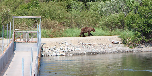
Then, I talked Scott into driving the 60-mile McCarthy Road in Wrangell-St. Elias National Park. He didn't want to do it in 2001 and I could tell he didn't want to do it this time. But, a Ranger said he'd seen Bears on the road, so off we went.
| No Bears, just scenery |
 |
| Fish wheels on the Copper River (famous for salmon) |
We saw many lovely sights as the weather started to improve.
 |
| Beaver lodge |
 |
| I wanted to see the mine |
I knew that, at the end of the road, you have to walk across a footbridge to get to McCarthy and that you have to take a shuttle to get to the Kennicott Mine, but I thought you could see the mine from McCarthy.
You can't.
We got to the footbridge just after 5:00 and the sign said the next shuttle up was at 5:30 and the last down was 6:30.
Scott didn't want to go, but I wasn't about to lose my second chance to see the mine. I jumped on the shuttle, grabbed lots of photos and made it back down on the 6:30 (turn out the schedule was wrong and the shuttle ran until 7:30).
 |
| The Kennicott (or Kennecott, they spell it two ways) mine |
 |
| An imposing structure |
There are quite a few buildings, in various stages of disrepair, from slightly tarnished ...
 |
| I could have stayed hours |
... to full disaster ...
 |
| Some is collapsing |
And, lots of old mining equipment ...
 |
| A variety of industrial-looking thingies |
The town affords a great view of the valley and of the Kennicott Glacier, which filled the valley when the mine was built.
There's a Visitor Center ...
 |
| The Kennicott Glacier and the distant mountains |
 |
| The NPS Visitor Center |
... and a National Park Lodge in the mine town ...
 |
| The Lodge (it wasn't open) |
 |
| I was surprised the bridge could withstand that rough water |
I had just showed Scott a few pix and I replaced my lens cap and turned off the camera - two things I often don't do and Scott is always on me about. Big mistake.
As we pulled on the road (narrow, gravel), suddenly we saw a giant female moose (about 6 1/2 feet at the shoulder!) running wildly down the road in front of two cars coming our way. I handed Scott the camera while turning it on, etc., because it appeared the moose would pass right by him. But it turned and ran straight up the hill.
That's when we saw a bicyclist who had dropped her bike and was backing up to get out of the moose's way. I clicked one shot and then the moose came back down. That's when I abandoned photography and went into rescue mode.
I opened my car door and called the bicyclist over the either get in or hide behind the door. The moose turned around again and ran back up the hill. It was a close call for the bicyclist, but she wasn't hurt. No pix except an empty road, though!
 |
| This is where I ended up with a bicyclist in may lap! |
The rest of the drive home was uneventful, except for some Tundra Swans in a pond along McCarthy road.
 |
| Mom and dad protecting their cygnets |
When we got to the highway, clouds cleared and the mountains emerged.
 |
| Wrangell-St. Elias has beautiful views |
A great deal of the Park is the Bagley Icefield, the second largest nonpolar icefield in North America. Mount Wrangell is 14,163 feet; Mount Elias, at 18,008, is the second tallest mountain in the U.S.
 |
| Evening view Since we're not long-distance hikers, we had to be content with views from the highway on the perimeter. |
 |
| So worth it! |
I later found out that Scott had changed his mind and tried to catch me at the shuttle to go to Kennicott. I am so sorry he missed it.
 |
| Such a shame Scott missed it |
Trip date: June 3-July 20, 2013