 |
| Pretty weather for travel |
The weather is amazing – but it wasn’t just a month ago.
And, so we have changed our plans.
 |
| Lots of light means pretty flowers |
As you know, we were already two days ahead of schedule
because the Alaska Highway is far more civilized (in terms of drivability) than
we expected, the weather has been clear, traffic has been light-to-nonexistent
and once we hit the Yukon, animals failed to appear. Plus, the 20+ hours of
light messes with you and we have a habit to getting up at 3:30 a.m.
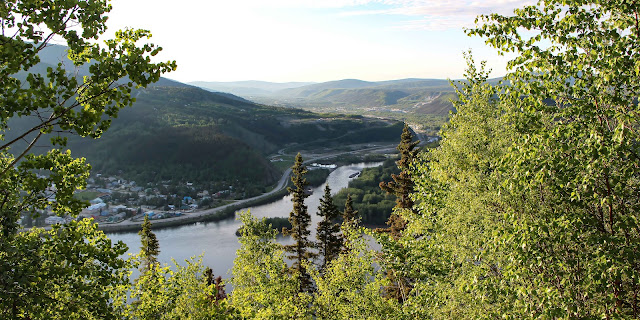
So, we got up very early and left Dawson City on the first
ferry.
 |
| The ferry across the Yukon |
We had to picnic it for breakfast because nothing was open in Dawson City.
 |
| A nice spot to picnic while waiting for the ferry |
The ferry operates 24-hours a day in summer, but at peak times, you can sometimes wait up to three hours. For us early risers, that was not a problem. However, we did have to wait for the ferry to finish its mandatory weekly inspection (the one the guidebook said was on Wednesday, but was being conducted on Friday).
 |
| Finally onboard |
The trip across the river takes less than 10 minutes and is free (it is basically considered part of the highway, since the only other option would be a 14-hour detour.
 |
| It's s cute little ferry |
It is a drive-on/drive-off single deck ferry and, because the ride is short, you have to stay in your car.
As mentioned, we had actually left the Alcan to take the more northerly route, the Top of the World Highway, which runs 79 miles from Dawson City through Yukon Territory to the U.S./Canada border through Chicken and on to Tok, Alaska. In Canada, it's Yukon Highway 9; in Alaska, it's Highway 5.
 |
| It's the only road in the area |
 |
| The road climbs considerably once you get off the ferry |
The highway has been in existence since at least 1955 and is only open during the summer months. It is a mix of pavement and gravel; most of the Canadian portion being unpaved.
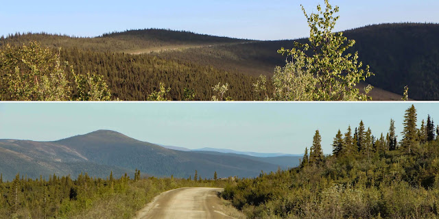 |
| The rustic Canadian portion |
The highway's name, comes from its route along the crest of the hills, looking down on valleys. One of the most northerly highways in the world, it is only topped by the Dempster Highway (Yukon Route 5) and the Dalton Highway (Alaska Route 11). It closes in winter, because with few trees for shelter, it is not particularly safe, even for snowmobile use.
 |
| A brief photo stop |
As I said, right out of Dawson City, is was beautiful ...
 |
| One last look at Dawson City |
... but, as we went on, however, I
would change the classification to just “pretty.” The road winds long the top
of ridges, so the view is endless – just rounded mountaintops covered with
spindly trees. No animals except two Porcupines and one Hoary Marmot.
 |
Both Porcupines had no time to pose; but I didn't even get the Marmot |
I suspect this could be a harrowing (or more harrowing)
drive in the midst of high tourist traffic. As it was, we were the only ones on
the road for the most part. There were a few other cars and some construction
vehicles. It is very bumpy gravel, winding and narrow.
We knew that the Poker Creek - Little Gold Creek Border Crossing wasn’t open until 8 a.m. (it is open only from 8 a.m. to 8 p.m., even when there is almost unlimited sunlight in summer), so we knew there would be little – if any – oncoming traffic.
Because we got a very early start, we figured we might have to wait a few minutes for the border station to open. When we got there, we realized that the time changes at the border and the stated opening time is Alaska time! We had a longer wait than expected.
 |
| The joint border station as we waited on the Canadian side |
Finally, we were the first to enter
Alaska that morning at what has to be among the most remote manned boundary stations. By the way, the Yukon has a big welcome sign there, the U.S. does not.
We continued on to Chicken, Alaska, which is 57 miles west of the border.
 |
| Chicken |
Chicken is one of the few surviving gold rush towns in Alaska. The population was seven at the time of the 2010 Census, down from 17 in 2000.
 |
| Willow Ptarmigan |
The outpost for the 40 Mile Mining District, Chicken still has active gold mines and inactive gold dredges. Enough gold was mined here to make it worthwhile to haul huge gold dredges to this remote location. A portion of Chicken, with buildings from the early 1900s and the F.E. Company Dredge No. 4 (Pedro Dredge), is listed on the National Register of Historic Places as the Chicken Historic District.
 |
| An outdoor second breakfast |
We had originally planned to stay there
overnight, but after we had breakfast (doughy pancakes and reindeer sausage for me), we realized there was no compelling reason to stay. and the RV "Park" was hideous (well, the whole town is actually pretty hideous).
 |
| Not very park-like |
I know we now
have an RV, but we don’t sleep in it every day (it’s just a bed on wheels, but we refuse to stay at RV parks that have no trees, no space and look
like parking lots. I mean, seriously, do most RVers never go outside the RV?
 |
| Preparing to head out |
Anyway, we headed on toward Tok, trying to decide what to do
with our extra days.
 |
| Along the highway in Alaska |
Scott was exhausted from driving; we were we discussing
two extra days in Fairbanks before going on to Denali. Then, we pulled out at a
viewpoint ...
 |
| Just taking a look |
 |
| Denali, "The Great One" |
Since most visitors to Alaska never see North America’s highest
peak, this was quite a treat.
So, this is where the good weather/bad weather comes in –
and, in Alaska, weather makes most decisions. Scott had wanted time in
Fairbanks to go north to photograph fireweed, a brilliant magenta flower that
opportunistically moves in after a forest fire. But, because of very late snow,
it wasn't blooming yet. So, we ditched Fairbanks completely and headed to
Denali, hoping the weather would hold.
 |
| It was on our agenda, just not this soon |
We pulled into Denali fairly late (still sunny) and quickly
ditched our plan to stay in a commercial RV slot (see comments about Chicken
above).
We could not get a slot in the NPS campground for two days (tourist
season here is much stronger than along the Alaska Highway). So, we booked
Riley Creek for Sunday and Monday nights and then found a basic cabin. We would go
back to our itinerary and camp at Savage River for three more days after Riley
Creek (it's a good thing our campsite moves so easily).
 |
| Our tent on wheels |
No comments:
Post a Comment