 |
| Amazing |
The drive from through Banff into Jasper National Park in Alberta, Canada, has to be one of the most incredible pieces of highway in the world.
 |
| Can you believe this? |
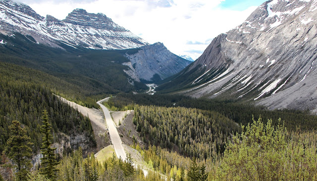
The Icefields Parkway
Called the Icefields Parkway (or, in French, Promenade des Glaciers), it is a 140 mile-long scenic road that parallels the Continental Divide along the border of British Columbia and Alberta, traversing the rugged landscape of the Canadian Rockies, going through Banff National Park and Jasper National Park.
 |
| Rugged country |
The road is named for the Columbia Icefield, which is visible from the parkway. The largest icefield in North America's Rocky Mountains, it comprises 125 squares miles of breathtaking jagged mountains and glaciers.
 |
| The Canadian Rockies are truly dramatic |
The Columbia Icefield was formed between 240,000 and 64,000 years ago, with additional glaciation occurring 20,000 to 11,000 years ago and then again during the Little Ice Age, which lasted from about 1200 to 1900 AD. Around 1800, the Athabasca Glacier peaked, then went through a period of recession, and then advanced again until 1840, when it began receding until the present day.
 |
| The Athabasca Glacier |
The Columbia Icefield was one of the last major geological features in western Canada to be visited and recorded by Europeans, due to its isolation and harsh weather conditions.
 |
| Harsh in winter, but nice in summer |
In 1827, Scottish botanist David Douglas was crossing Athabasca Pass, a major trading route located north of the Icefield, when he climbed one of the adjacent mountain peaks. He reported his first ascent in his journal, describing it to be 20,000 feet in height.
 |
| A little exaggeration; mountains are more in the neighborhood of 11,000-12,000 feet |
 |
| Tangle Falls |
In 1884, geology professor Arthur Philemon Coleman explored the Great Divide from Banff to Jasper in search of Douglas' giant peak.
While unsuccessful, he did discover the route that would become the Parkway.
In 1898, British explorer J. Norman Collie and his friends Hugh Stutfield and Herman Wooley set off to find Douglas' giants.
What they found was an an icefield that extended to almost every horizon.
 |
| Extreme glaciation |
Jasper National Park
And, if that's not enough, the next stop is beautiful Jasper National Park. Established in 1907, it is the largest National Park in the Canadian Rockies with almost 4,300 square miles of mountain wilderness.
Jasper is home to healthy populations of Black and Brown (Grizzly) Bears ...
 |
| This is a Brown Bear from Kootenay; I saw some in Jasper, but got no pictures |
... Moose ...
 |
| A young Northwestern Moose |
... Elk ...
 |
| A medium-sized bull |
 |
| An Elk nursery |
...Bighorn Sheep ...
 |
| A beautiful ram |
... Coyotes ...
 |
| Look at those eyes! |
.. and Caribou and Wolves, which we did not see (drat!).
Jasper National Park has jaw-dropping scenery, including jagged mountains ...
 |
| Incredible peaks |
... steep cliffs ...
 |
| An imposing face |
... glacier-fed rivers that are an unbelievable milky turquoise
and this time of year running faster and rougher than any river I’ve
ever seen ....
 |
| A glacial river |
... beautiful mountain-ringed lakes ...
 |
| Maligne Lake was dreamy |
The topography includes slot canyons, many carved by
waterfalls. We hiked Maligne Canyon back to the 4th bridge. It’s
incredible, carved in twists and turns and feed by both aboveground and
underground rivers.
 |
| A wide variety of falls and cascades |
Then, we visited Miette Hot Springs, where we soaked for an hour. Heaven!
 |
| Miette Hot Springs is highly developed, but what a view! Photo: TravelAlberta |
Our campsite in Jasper National Park was fine, but not as wooded as we like (Glacier
was much nicer). I think that’s the price you pay for getting hook-ups – the
advantage is that no one else uses the restrooms (with great HOT showers).
People are fascinated by our
Little Guy. It’s remarkably comfortable and not a pain to haul like an RV.
Plus, we’re getting 19 mpg!
 |
| A nice way to travel |
 |
| Pine Squirrel having its own picnic |
I must say, the U.S. does have it over Canada on National Park maps and interpretive materials. It’s hard to find maps in Canada and they
don’t include much information, such as where the picnic areas are. And, frankly, there are not as many picnic areas as we had hoped.
We ended our stay with a drive to the west where we saw
and photographed several Grizzlies (well, Scott got out and took pictures; I thought they were very close and stayed in the car).
 |
| Scott is really close to the Brown Bear (you can just see its back) |
That left us undecided whether we wanted to drive our next
leg via 16 and 97 (a long day that included the bear-rich area we had just driven)
or 40 (faster and not covered in Milepost).
Trip date: June 3-July 20, 2013
No comments:
Post a Comment