Friday, April 21, 2017

Bandelier and Home

Up the ladder
The next morning we visited Bandelier National Monument, another place I had been years before – but haven’t blogged about. Bandelier was my first cliff dwellings. I have been to many, many since then. But, these are still very impressive.

The 50-square-mile monument preserves ground and cliff dwellings of Ancestral Puebloans dating between 1150 and 1600 AD. Although it is known for cliff dwellings, the Monument is actually about 70 percent wilderness, rising from the Rio Grande to the peak of Cerro Grande on the rim of the Valles Caldera (more about that later).

Bandelier was named for Adolph Bandelier, a Swiss-American anthropologist who researched the cultures of the area and supported preservation of the sites. The park was designated in 1916 and the infrastructure was developed in the 1930s by the Civilian Conservation Corps. I didn’t take any pictures of the lovely Visitor Center. I should have.

Interestingly, during World War II the monument area was closed to the public and the lodge was used to house personnel working on the Manhattan Project at Los Alamos to develop an atom bomb.

Looks like a Scotty
The area is covered with Bandelier tuff volcanic ash from the Valles Caldera volcano eruption 1.14 million years ago. 

The lava varied in hardness; the Ancestral Pueblo People broke up the firmer materials for bricks and carved out dwellings from softer material. 

Human presence in the area has been dated to 10,000 years ago. Artifacts from the area indicate that the community was part of a regional trade network that included what is now Mexico. The people who lived there are know as Ancestral Pueblo Peoples. They were formerly called Anasazi, which is actually a Navajo word that means "ancient enemies." That's why the descendants didn't like that name!

A view from above
In the past, it was believed that these people mysteriously and suddenly disappeared. But, current information indicates gentle migration to close-by areas. 

At first, they planted but did not cultivate native plants, including corn, squash and beans. But, later they developed agricultural techniques that took better advantage of scarce moisture to feed a larger number of people. This included terracing, check dams, grid gardens and irrigation channels.

As they became more agricultural, they moved down from the cliffs to the valley floor. 

Then, they spread out closer to the nearby  Rio Grande River. Spanish colonial settlers arrived in the 18th century. Bandelier first visited the area in 1880.

The dwelling site, which is in Frijoles Canyon (Bean Canyon) is reached along a 1.2-mile mainly paved loop trail from the Visitor Center. 

Old walls
First, you walk through the village of Tyuonyi (QU-weh-nee), one of several large pueblos found in Bandelier.

One-to-two stories high, Tyuonyi had about 400 rooms and housed about 100 people. It was reached through a single ground-level opening.

Interestingly, some of the building techniques appear to be imported from far away, suggesting frequent interaction among far-reaching ancestral peoples of the southwest.

Among the rock structures built on the canyon floor, is this ceremonial kiva (one of three on the valley floor), which would have had a wooden roof ... 

An open kiva
The rooms on the cliff were built in “cavates” produced by voids in the volcanic tuff of the canyon wall and carved out further by humans using only stone tools...

Houses hugging the cliff; Photo: Caty Stevens
This cliff faces south, which would have made it much warmer in the winter and much cooler in the summer than had it been on a north wall -- natural climate control. 

The outer buildings are gone, but you can still see foundations and beam holes
The lower walls were usually plastered and painted and the ceilings were blackened by smoke. This wasn't just an accident caused by heating and cooking; it was actually a technique that hardened the crumbly volcanic tuff to prevent it from falling on the inhabitants.

Some of the structures were reconstructed in the 1920s. Recent research indicates that the reconstruction may have been done incorrectly.

Reconstructed buildings
These recreations put doors in the front of the rooms, but new evidence suggests that the people living there probably entered their dwellings via openings in the roof.

You can see some of the wall decorations that were protected by walls, but are now open to the elements. 

One particularly bright petroglyph is protected by glass
There were a few petroglyphs on the canyon walls.

CW: a stylized human-type figure, a Macaw, an alien-looking figure and a bird
You can look into some of the structures by climbing up ladders similar to the ones the Ancestral Puebloans used ...

Caty takes a peek
The population in Frijoles Canyon probably reached its highest point in the early 1400s, when about 500 people lived on both the cliff and the valley floor. The pueblo was abandoned by 1600. The inhabitants relocated to pueblos near the Rio Grande, such as Cochiti and San Ildefonso, which are still occupied. Life expectancy, by the way, was about 35!

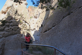
The railings protect the dwellings
We did only the loop trail. It connects to the Frey Trail, which goes out of the canyon. The trail was named after the family that operated the first tourist lodge in the canyon. 


In the early days, there was no road. Visitors hiked or rode in on horses or mules.

We didn’t see a lot of wildlife, but on the cliff face by the dwellings, we saw Canyon Wrens ...

Look how long that bill is
A Giant Flag Moth Caterpillar -- one of the most colorful caterpillars I have seen ...

Maybe inspiration for early native designs? Look at that preserved wall decoration above
And a Mule Deer, which Caty frightened, causing it to jump out of the bushes, which, in turn, frightened us. ...

Hey!
We walked back to the Visitor Center along Frijoles Creek (Bean Creek)..

Just a small creek
... where we encountered a Spotted Towhee, a very pretty bird that was hiding in dark bushes ...

Look closely to see its red eyes
And a Fence Lizard …

Next to, but not on, the fence
It was a beautiful day and a very pleasant walk through the ruins. It’s always a good day when you can visit ancient cliff dwellings.

Stops on the Way Home
Of course the day was getting late, but, as is our style, we wanted to make a few more stops. We drove along the edge of the high country of Bandelier to another newly designated spot -- Valles Caldera National Preserve, a 13.7-mile-wide volcanic caldera in the Jemez Mountains. 

Looks like a housing development sign
Valles Caldera is one of the smaller volcanoes in the supervolcano class and is the younger of two calderas known at this location. It buried the older Toledo Caldera, which in turn may have collapsed over yet older calderas. The youngest eruption of Valles Caldera was about 50,000 to 60,000 years ago. 

Seismic investigations show that a low-velocity zone lies beneath the caldera, and an active geothermal system with hot springs and fumaroles exists today.

We drove down a two-mile gravel road to the Visitor Center. Most of the Preserve doesn’t open until May – it is at a high elevation – so there wasn’t much we could do.

Not prime season yet; Photo: Caty Stevens
We made a few last stops – very briefly at Rio Grande del Norte National Monument, which I covered in a 2016 post. But, after we arrived, we decided we really needed to get home so that Caty could make it to work the next morning.

Quick stop
It was a lovely trip with revisits of extraordinary sites I’ve seen before and a couple of new places. I have now officially visited every NPS-administered site in New Mexico and a lot of the BLM ones. It is a beautiful state. And, the Guadalupe Mountains part of Texas – by far the highest point in Texas – ain’t too bad either.


Trip date: April 6-10, 2017

Thursday, April 20, 2017

Lakes, Petroglyphs, Lava and Food

So, we felt that we had sufficiently seen both the National Parks, so we started our trip north-ish the next day. I saw “north-ish” because we detoured a bit. And, we saw some very cool stuff, which I will cover later.

Petroglyphs
We started out heading to Bottomless Lakes State Park, which for me is probably more nostalgic than it is actually worth the side trip. 

Pretty, but ...
It is one of the places my family visited on our 1958 summer vacation that imprinted so much on me, probably starting my wanderlust. 

I visited it a few years ago -- click here to read.

It was, again, quite windy. 

As we neared the park – which you better have GPS for because you won’t see a sign until you are there – we encountered birds I had been trying to find: a flock of Long-Billed Curlews and a White-Faced Ibis.

I pulled over, struggled out of the car. Did I say it was quite windy? And was immediately assaulted with a gust. I got ONE picture before the wind sent the birds flying out of range.

We never saw them again
Bottomless Lakes State Park
Established in 1933, Bottomless Lakes State Park is about 15 miles southeast of Roswell. It has nine small, deep lakes along the eastern escarpment of the Pecos River valley. The escarpment is an ancient limestone reef, similar to the limestone mountains at Guadalupe Mountains. Caves formed within the limestone, and as the river eroded the escarpment, the caves collapsed, leaving behind several deep, almost circular lakes known as cenotes.

A cenote
The cenotes range in depth from 18 to 43 feet; The bigger lakes -- Lea and Lazy Lagoon both reach 90 feet deep.

Lea Lake
Most of the nine lakes are almost completely surrounded by cliffs, with the exception of Lea Lake and Lazy Lagoon. 


Lea Lake has a large, sandy shoreline on the western side and tall cliffs on the eastern side. It is the only lake where swimming is allowed. 

It has a beach, picnic area, playground and concessions. When I first went there, there was also a swimming pool. But, it was damaged in a flood years ago and removed.

But, the picnic area right by the lake each have a little hollowed-out area that is almost like a private shallow pool connected to the bigger lake.

Clear water
The lakes are fed by underground water percolating through the rocks rather than by streams. 


The evaporation rate in the hot desert climate exceeds the rate rainwater refills the lakes, which can cause the water to become stagnant.

We drove around Bottomless Lakes, but the wind was really making doing anything else difficult. The Visitor Center was closed, so we decided to head on.

We had read about another potentially interesting place – Three Rivers Petroglyph Site – that wasn’t quite on a direct route home (in fact, it was very close to Alamogordo), but I am so glad we went.

Smoky Bear
The drive was pretty, up over some mountains, including passing by Smokey Bear Historical Park in Capitan, N.M. We stopped at a roadside sign, but not at the actual park, which is right in town amidst a number of businesses that ALL have bear-related names.

Completed in 1979, Smokey Bear Historical Park honors a little bear cub that was found with burned paws after a nearby forest fire in 1950. The publicity surrounding his rescue inspired the face of wildfire prevention that we all love -- Smokey Bear. Note, we always said, “Smokey THE Bear,” but correct usage is “Smokey Bear.”

After living in the National Zoo in Washington, D.C., for 26 years, Smokey died and was returned to Capitan to be buried at what is now the Smokey Bear Historical Park. 

Three Rivers Petroglyph Site
Three Rivers Petroglyph Site is also managed by the BLM and it’s really fantastic. 

There are over 21,000 petroglyphs in the park, many of which can be easily viewed from a mile-long round-trip trail that winds up a small hill and through piles of rocks decorated with all kinds of petroglyphs -- drawings scratched or chipped into the veneer of the rocks. 

The drawings are thought to have been created by the Jornada Mogollon (pronounced mug-gee-on) people between about 1000 and 1400 AD.

The number and concentration of petroglyphs make this one of the largest and most interesting rock art sites in the Southwest.

A great find!
The petroglyphs include many images …

CW: Mask, Eagle, Warrior, Sunburst and Roadrunner
CW: Man, sunburst, eyes/Owl, Lizard and Man, Bird, Person
CW: Ram, hand, Spider or Lizard, Ram pierced by arrows
The views are quite pretty from the trail. You can even see White Sands off in the distance.

White sands is to the left, where there is a slight white haze on the surface
Another short trail begins on the east side of the picnic area and leads to a partially excavated prehistoric village. We didn’t have time to visit that site. Maybe next time.

Three Rivers would be a fantastic place to take children. You could turn the hike into a scavenger hunt for specific designs. I imagine it is quite hot in the summer, which is why there is a nice shade shelter at the far end of the hike. We didn’t see any animals, but it would be wise to watch for snakes.

Panoramic
Oh, a note about the BLM. They are “transitioning” their website in what appears to be a disastrous migration. All BLM site links are broken, so navigating to park information is tricky. I could find information on Three Rivers ONLY on recreation.gov. This follows a pattern. I don’t think BLM really cares if you visit their sites the way the NPS does.

Valley of Fires
A new one for us
The day was waning and we needed to get on the road. We decided to stay in Los Alamos so that we could visit Bandelier National Monument on our way home. So, off we headed. 

On the way, we drove through another BLM site: Valley of Fires Recreation Area. 

This area showcases part of the Carrizozo Malpais, a large lava flow that came from Little Black Peak, which erupted about 5,200 years ago. 

The highway crosses over the flow, which encompasses solidified pahoehoe (pronounced paw-hoey-hoey) and aa (pronounced ah-ah) lava. 

Lava; Photo: Caty Stevens
Pahoehoe has a smooth, billowy, undulating or ropy surface due to the movement of very fluid lava under a congealing surface crust and aa has a rough or rubbly surface composed of broken lava blocks. 

Rough ground
The lava flow, while covered in a variety of desert plants, is still – even after more than 5,000 years – very definitely lava.

A bit more vegetation
There is a campground and trails in the area. A few years I visited El Malpais National Monument, another BLM site that showcases this massive flow (to read, click here). Malpais is a Spanish word that means “badlands.”

Dinner in Albuquerque
Now, we had to rush on because we wanted to take another shot at getting some good New Mexican food and we figured Albuquerque was our best chance. And, knowing what we knew, we had to make it by 8:00 p.m. We did, with time to spare. And, we ended up eating in a place that I tried to go to once when I was staying in Albuquerque. That’s the night I discovered NOTHING is open late.

Cocina Azul is casual but, OMG, how fantastic! I was not impressed with the chips (not made in-house) and salsa (one too mild, one too hot). 

Oh, oh, oh
But, after that, WOW! I had a “desebrada” enchilada: blue corn tortillas stacked with marinated beef and jack cheese, smothered in green and red chile. Fortunately, I also ordered sour cream. The red chile was hot. Seriously hot. Very hot. Hot. But, it was yummy. I had buttery rice and buttery squash on the side. 


More yummy. 

Icky beans
Caty had steak tacos. Also yummy. But, not the greatest beans. We like black beans, not borracho beans. 

There was, however, so much food in the main courses that the sides weren't really necessary. I found, however, that the rice and veggies were good foils for the super hot red chile.

And, for dessert, we had sopapillas like none I have ever had: light, airy, no icky sauces, no grease, no cinnamon sugar. Pure perfection with just a little honey. We were too enthralled to take a picture!

If you go to Albuquerque, go to Cocina Azul. Before 8:00 p.m.

Then, a drive to Los Alamos in the dark. I guess I had forgotten that Los Alamos is reached via winding mountain roads. Still, we arrived and slept before our last day on the road.


Trip date: April 6-10, 2017

Wednesday, April 19, 2017

Guadalupe Mountains National Park

After we looped around Carlsbad Cavern's Scenic Drive, we hit the road for Guadalupe Mountains National Park, which is about 36 miles south of Carlsbad Caverns, just over the Texas border. Click here to see my blog about the first time I went.

An impressive edifice
Guadalupe Mountain, just like Carlsbad Caverns but unlike most of Texas, is in the Mountain Time Zone. But, be forewarned, GPS and telephones seem to get very confused about this. The time on our phones kept switching back and forth. That can get very confusing.

We we arrived at Guadalupe Mountain, the scourge of the desert had raised its ugly head. It had gotten windy. Very windy. That made hiking much less appealing. So, we started at the Visitor Center, which may have a new sign. I don't remember this one.

Does this look like Texas?
We watched the film, did a short walk through the Frijoles Ranch (the museum was closed – as it always seems to be – this time because the volunteer who was running it had to go back to Iowa to plant his crops – really).

This does look like Texas
The ranch was built by the Rader Brothers next to Frijole Spring in 1876. It comprises seven buildings: ranch house, bunkhouse, barn, double outhouse, springhouse, shed and school house. Most of the buildings are built of local stone. All are surrounded by a stone rubble wall. 


The complex represents the most complete early ranching operation in the Guadalupe Mountains.

The Rader brothers left the area in the late 1880s and the property passed among several families before eventually being sold to the National Park Service in 1966 for $1.5 million.

Springhouse channel
One of the really cool things on the ranch is the springhouse and the little channel of fresh spring water that flows out of it. Because the house area is built next to several springs, it is a cool, green oasis in the middle of a scrubby desert landscape. Apparently, further up in the mountains (where we didn't hike) there are lots of cool, green areas with ecosystems generally found much farther north.


After looking at the buildings, we took the short, paved trail to nearby Manzanita Spring. The last time I was there, the trail had been damaged by a flood and was NOT accessible. It is now.

There's a pretty little pond at Manzanita Spring, surrounded by reeds.

Looks like a good birding spot
On our walk -- our very breezy walk -- encountered what we thought was a Golden Eagle way up high (too high for good pictures), but we later decided might have just been a very dark Red-Tailed Hawk. It was hard to tell (that’s how high it was). We also saw Turkey Vultures -- lots flying and a few that actually landed ...

They are usually soaring
Woodhouse’s Scrub Jays ...

A pretty bird (and large!)
Two very colorful Greater Earless Lizards (look closely to see the red dots on its back and green and black bands on its belly) ...

You can't see it, but it also has bold black stripes on the underside of its tail
With the exception of some bright cactus flowers, the landscape generally fairly brown and thirsty-looking.

Some relief in the desert
Guadalupe Mountain has no roads to speak of, so hiking is really the only way to see the park in detail, but I think the three different entrances give you a fairly good representation.

We scrapped our plans to hike to Smith Spring, the hike I had done in 2014, because the wind was just too unpleasant.

We then decided to make the drive around the southwestern end of the mountains and set up for sunset pictures. 

Not enough wind protection
We had an in-car picnic (we do that when we encounter wind). 
The picnic shelter had a very quintessential Texas look, but we found the orientation odd. It didn't seem to protect from the sun at any time of day -- and it didn't seem to block the wind. Maybe some other time of year ...

We took lots of pictures both from the picnic overlook ...

The Park's namesake
... before heading further southwest to set up for evening shots. There was no pullout that didn't have a blocked view, so we just pulled over on the shoulder. 

A look from across the desert
Since it's not really a high-traffic area, it wasn't too bad. We talked about how we could possible do nighttime star shots, but I think the shoulder might be dangerous in the dark.

Late afternoon
There were no clouds, so the sunset wasn’t everything we wished for. But, it was pretty and, as we were shooting, the wind did die down quite a bit.

El Capitan
The main -- and very impressive -- peak is named El Capitan (that seems to be a common mountain name).  Although it is the eighth highest peak in Texas, it is considered to be the "signature peak" of West Texas.

El Capitan is the southern terminus of the Guadalupe escarpment, an ancient limestone reef (this area was once under an ocean) that forms the present-day Guadalupe Mountains. It is guarded by cliffs on three sides and is rarely climbed because the rocks are unstable. Hikers can reach the summit by first climbing Guadalupe Peak and then scrambling down to the south to the Guadalupe Peak-El Capitan saddle, then up the backside of El Capitan. I think I would rather just look at it.

Getting later
An added treat was an almost-full Moon in a clear sky (unfortunately opposite, not over, El Capitan).

Too bad I couldn't move the Moon
It was also a treat to be outside in the evening without even needing a jacket.


Trip date: April 6-10, 2017