Since we had gotten an early start, we had quite a bit of
day ahead of us before we needed to head out to Carlsbad. So, since we had seen
the dunes and we didn’t anticipate that animal activity would pick up as the
day got sunnier, we decided to visit a new National Monument that neither of us
had been to.
 |
| Interesting rocks |
Organ Mountains/Desert Peaks National Monument (that’s a
mouthful) is managed by the Bureau of Land Management as part of the National
Landscape Conservation System. National Monuments can be managed by the NPS or
BLM and, often, you don’t hear as much about the BLM sites. But, many are
spectacular.
And, “spectacular” is the word used on the reviews we read online about Organ Mountains/Desert Peaks National Monument. So, why not go?
It protects a variety of geological, paleontological and
archaeological resources in the Chihuahua Desert.
Half of the monument is designated wilderness and
closed to development or cars. It has three big units near Las
Cruces.
The protected area includes five mountain ranges – Robledo, Sierra de las Uvas, Doña Ana, Organ and Potrillo.
The protected area includes five mountain ranges – Robledo, Sierra de las Uvas, Doña Ana, Organ and Potrillo.
The
Monument protects archaeological/cultural sites, including WWII bomber
target practice sites, Apollo Mission astronaut training areas and 22 miles of
the Butterfield Stagecoach Trail.
There are 243 known archeological sites,
including some of the earliest Native American settlements and petroglyphs made
by three different tribes.
Before the Gadsden Purchase, Organ Mountains/Desert Peaks
included the border with Mexico. More recently the area was used
by both Billy the Kid and Geronimo.
 |
| A wide view; Photo: Caty Stevens |
Of course, we didn’t visit any of those sites. We did,
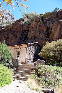
however, take a lovely short hike to Dripping Springs, which was the site of an
early tourist resort.
 |
| An old tourist spot; Photo: Caty Stevens |
 |
| Old buildings; Photo: Caty Stevens |
 |
| A building up against the cliff |
The Dripping Springs resort was a two-story 14-room hotel with dining and recreational facilities. Made of native rock from the canyon, it was held together with mud-mixing plaster.
The grounds were landscaped and featured a gazebo bandstand. Interior ceilings were covered with tightly stretched muslin and patterned wallpaper decorated many of the rooms.
There was a livery, where guests could stable horses and mules and park coaches and wagons. He drew staff from the Tortugas Indians.
 |
| More ruins; Photo: Caty Stevens |
 |
| Old barbed wire |
By 1916, Van Patten, bankrupted by legal costs, turned Dripping Springs over to Boyd, selling it to him for $1.00.
Boyd, educated in San Francisco, moved to Dripping Springs after his scheme to build a dam and sell irrigation water to farmers below the dam at outrageous prices collapsed. He chose the area because his wife had tuberculosis.
He operated the sanatorium until 1922. Later the Dripping Springs land was used for livestock.
The springs, which seep out of the rock, form a very small dripping waterfall. Based on evidence as we hiked, it appears that the stream coming from the springs can also an also become a torrent. There were a lot of downed trees and brush in the streambed.
 |
| The stream |
 |
| A nice morning; Photo: Caty Stevens |
The area with the ruins of the resort and the sanatorium are roped off to prevent you from walking through the buildings. Some are badly broken down and some are remarkably intact. Some, even still have screen in the doors and windows.
 |
| Screen door |
The trail is referred to as a "loop," but it's all pretty much the same route out and back with just a little loop at the end.
There isn't a lot of shade along the way, so in the summer time, it might not be as pleasant as the balmy, breezy day we hiked.
We saw a few critters along the route …
We saw a few critters along the route …
 |
| Chipping Sparrow |
 |
| Mule Deer |
 |
| Black-throated Sparrow |
 |
| Hermit Thrush hiding beneath the springs |
 |
| More Say’s Phoebes |
 |
| And, some really pretty cactus flowers |
 |
| A nice walk; Photo by Caty Stevens |
Now, however, it was time to hit the road. It’s a long and
very isolated drive to Whites City. We opted to swing through El Paso (sorry,
NOT a pretty city) and up past Guadalupe Mountains. This area is in Texas,
making this a two-state adventure.
 |
| Guadalupe Peak |
The weird thing is that the “No Services” warning doesn’t show up until you are a good 20 or more miles past the last services.
It seems to me that the sign should be by the last gas station. Had we run too low, we could have taken a 28-mile detour near on the route, but it was fine.
We arrived fairly late and tired, making a mental note that the southwest approach to Guadalupe Mountains might be the most spectacular (and the word is appropriate here) and it would be good for sunset photos the next night.
Trip date: April 6-10, 2017

No comments:
Post a Comment