 |
| Gunnuhver Hot Springs on the Reykjanes Peninsula; Photo: Scott Stevens |
 |
| They actually did do it our way! |
However, as I hoped would happen, when we went to pick up the car at Keflavik Airport, we explained the situation and Europcar combined the two rentals. We got to keep the car we had, we didn’t have to drive to and from Reykjavik and we were able to turn the car in to the office at Keflavik.
 |
| Keflavik is convenient to anything on the peninsula |
But, I am ahead of myself. Let's talk about Reykjanes.
Reykjanes Peninsula
 |
| Chart: Wikipedia |
The Mid-Atlantic rift, which separates the North American and Eurasian tectonic plates, runs across the entire country of Iceland and, indeed, is why Iceland exists because the magma that fueled Iceland’s volcanoes rose up through this rift.
Volcanic and geothermal activity is visible almost everywhere, especially on the Reykjanes Peninsula.
 |
| This landscape makes development difficult |
The area is covered with lava fields, hot springs and evidence of past eruptions.
During the Middle Ages, many eruptions occurred in Reykjanes, but none had been recorded there since. Until Fagradalsfjall poked its head out this year, that is.
 |
| Not much grows except tundra-type plants |
 |
| The shrinking, bubbling lake |
In 2001, one beneath Lake Kleifarvatn drained it to the extent that it lost 25 percent of its surface area. Since then, hot springs have been bubbling beneath its surface.
The geothermal power station at Svartsengi produces 76.5 MW of electricity from the 475 litres of 195 °F water that gushes from the earth per second. The mineral-rich surplus water fills up the Blue Lagoon Spa, which is one of Iceland's most popular tourist attractions. We didn't visit this time. I much prefer natural pools to this manufactured spa.
 |
| Power plant, Blue Lagoon (Bláa Lónið), 2014 |
The Peninsula's north side is dotted with fishing villages and towns, most notably Keflavík (where the airport is located), Sandgerði, Garður and Vogar. Grindavík (where we stayed) is located on the south shore of the peninsula. The towns on Reykjanes make up the municipality Reykjanesbær, which has less than 16,000 residents, but is still the fifth largest municipality in Iceland.
 |
| It's more scenery than people |
Known for violent waves and wind, Reykjanes would probably erode away if it weren't for replenishment from volcanic eruptions.
 |
| Below the Reykjanestá Cliffs |
Let me tell you about the places we visited on the Reykjanes Peninsula, some on the morning before we drove back out to Vík í Mýrdal and most on our last day before our late afternoon departure.
Krísuvíkurberg Cliffs
Primarily known for 60,000+ nesting birds that were long gone when we visited, the black volcanic Krísuvíkurberg Cliffs drop abruptly from a flat grassy plain to the ocean.
 |
| Lava cliffs jutting into the ocean |
On the blustery day we were there, they looked moody and dramatic. But, without birds, there wasn’t a lot to see.
 |
| There were Northern Wheatears! |
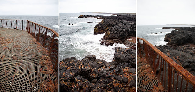
A colorful geothermal field of mud pools and fumaroles, Gunnuhver drives home the unpredictability and instability of geothermal areas. One of the mud pools has expanded in recent years and, now, you can see the engulfed remains of the old path.
 |
| Walking could be dangerous |
 |
| Danger!!!! |
After seeing the destroyed path, you wonder if the (obviously new) platform is even safe.
 |
| The geothermal areas have vibrant colors |
Gunnuhver is named after Gunna, a woman who lived on a farm on the Reykjanes Peninsula about four hundred years ago. She was quite poor and when she was unable to pay her rent, her landlord took one of her only possessions, a cooking pot, as payment.
 |
| Drawing: SilviaDottiIllustration |
The body of the landlord was later found mutilated and his wife was found murdered. Everyone suspected that Gunna’s ghost was responsible. She then began to haunt the peninsula, driving many residents mad.
The locals asked a priest named Eirikur to help.
 |
| Drawing: Vintage Times |
Near Gunnuhver there are lots of industrial areas tapping into the underground hot springs. On a cool, misty day, they create some pretty impressive steam clouds.
 |
| Nearby industrial action |
Reykjanes Light
 |
| Reykjanes Light |
We saw the Reykjanes Light when we were walking around Gunnuhver. We consulted Google maps to find our way there, only to discover that it is a big tourist attraction we should have known about.
The first lighthouse in Iceland was constructed on the Reykjanes Peninsula in 1878, only to be destroyed by an earthquake eight years later.
The current lighthouse was built on the site in 1907-08 and was upgraded in 1929.
At 102 feet tall, it has a much more traditional look than most of the industrial-looking lights in Iceland.
 |
| The best lighthouse in Iceland |
It sits majestically on the top of a hill and has been determined to be Icelanders’ favorite lighthouse. Unfortunately, the hill it sits on is eroding and the lighthouse may need to be replaced soon.
Reykjanestá Cliffs
Just beyond the lighthouse are the Reykjanestá Cliffs, which are also active nesting sites for European Herring Gulls, Northern Fulmars, Black-legged Kittiwakes and Ravens in the summer.
 |
| An interesting uplift where lava met ocean |
No birds remained when we visited, except a statue that I thought was oddly placed and strangely large.
 |
| Great Auk |
It turns out that it is an accurately sized statue of a Great Auk by American artist T McGrain. The statue faces Eldey island, where the last two birds of the species were killed in 1844.
Even devoid of birds, Reykjanestá Cliffs is an interesting spot that bears testament to Iceland’s violent and turbulent creation. Here, the waves are regularly known to reach heights of nearly 100 feet.
 |
| Lava cliffs, sea stacks and boulders are pounded by the sea, creating dramatic landscapes |
Brimketill Lava Rock Pool
Carved by pounding waves against soft lava rock, Brimketill is a large natural pool that sits at the bottom of a cliff at the ocean's edge.
 |
| While centuries old, the lava still seems new |
I found out about it by reading an article in Guide to Iceland that talked about the treacherousness of visiting it in winter. It appears, however, that the article was written before an observation deck was built.
 |
| Brimketill would be hard to find without signs and a path |
Now, it’s not too scary, but based on the seaweed littering the deck and the shore, it appears it can get crazy when the sea is rough or the tide is high.
 |
| It looks like the sea can get violent |
From the deck, you can look down on the pool that fills with water as waves rush in, creating whirlpools in the water. Indeed, Brimketill means “whitewater cauldron.” Local folklore says that the natural pool was owned by a giantess, who used it to wash her clothes and bathe.
 |
| I guess it beats bathing in the ocean (how would you even get down there?) |
The Bridge between Two Continents
The the Mid-Atlantic Rift bisects Iceland. West Iceland, much of the north and much of the Highlands is in North America and the rest of Iceland is on Eurasia.
 |
| A bridge over the rift |
 |
| Signage onsite |
The best place to actually see the Mid-Atlantic Rift is in Þingvellir National Park, which we have visited on past visits and didn't stop at this time because we passed it during a downpour. But, there is a good spot to visit on Reykjanes. The Bridge Between the Continent sits in the rift and runs in the direction between the plates, providing a symbolic opportunity to walk from North America to Eurasia.
 |
| I assume the bridge must be moved or shored up frequently as the rift slides |
It’s just a little bit of geologic fun.
 |
| The love-ly path to the bridge (art courtesy of local school kids) |
Time to Go
By the time we left, we felt that we had thoroughly seen the Reykjanes Peninsula, except for that pesky volcano.
 |
| The trip |
But, now I still need to see an active volcano. Plus, we saw so many places I would like to return to.
So, who knows?
But, we did finally have to leave. It was an easy trip home.
And, it was a marvelous trip.
We put over 4,000 miles on our rental car and we saw almost everything one can see around the perimeter of this beautiful country.
 |
| The Hringvegur rocks!; Top photo: Scott Stevens |
 |
| Wild things |
 |
| But, we did see some! |
 |
| Such beauty! |
 |
| A variety of rustic and colorful buildings; Bottom right photo: Scott Stevens |
 |
Goðafoss; Photo: Scott Stevens |
 |
| Massive peaks everywhere |
The surprises!
 |
| Unexpected delights |
 |
| One of the driving forces of Iceland |
The horses!
 |
| Icelandic Horse; Photo: Scott Stevens |
 |
| Such history; Photos: Scott Stevens |
 |
| Jökulsárlón; Photo: Scott Stevens |
The Puffins!
 |
| Such a treat! |
Iceland is a spectacular country. It’s easy to get to and easy to travel in. While a bit pricey on the food and beverage side, there are lots of affordable (and often interesting) lodging choices. The people are nice and there is little crime. And, you can truly, truly get away from it all when there.
I highly recommend that you go.
 |
| Ah! Iceland! |
Trip date: August 13-September 1, 2021


