 |
| Arctic Henge in Norðurlands |
We were heading on our last major detour off the Hringvegur, driving north to Raufarhöfn, Iceland’s northernmost town. I don’t know exactly why I wanted to go to Raufarhöfn, possibly just because of its novelty.
 |
| This looked so appealing; Photo: Booking.com |
I’ll get back to that later.
The day dawned a bit murky and weather forecasts were getting worse. I felt fine about it because we had been blessed with some really pretty days. Scott, not so much. I hadn’t realized how important aurora had been to him and he was getting impatient. I never counted on it, so I figured any we got was a plus.
We headed north along the same route we had taken to Dettifoss, but since the weather was no better than when we went before, we didn’t stop. Instead, we continued to Hljóðaklettar.
Hljóðaklettar
We followed GPS and discovered that the first road we were directed to was just an overlook. So we drove down what was obviously a road-being-constructed and found it. It was misting (maybe even drizzling), but I hiked down anyway.
 |
| Impressive basalt columns |
Hljóðaklettar means “echo rocks” or “murmuring cliffs” because these unusual twisted volcanic formations create acoustic effects that makes it impossible to determine the direction of the roaring river.
 |
| You can see how the formations would affect sound by the river |
I didn’t know that when I was there, but I did notice that I got easily turned around when trying to use the river for navigation.
 |
| A trailside stream and one of the formations |
Part of the Vatnajökull National Park, Hljóðaklettar is just about six miles downstream from Dettifoss in Jökulsárgljúfur Canyon. The cliffs originated from lava produced by the Rauðhólar volcano that contracted as it cooled, creating perfectly aligned prisms with four to six faces.
 |
| From a different angle |
Then, the powerful Jökulsá á Fjöllum river that flows from the Vatnajökull glacier eroded away softer material, leaving twisted columns and caves.
 |
| An impressive site |
Instead of gradual erosion, it is believed that Jökulsárgljúfur and its surroundings were cut into the bedrock through a sequence of catastrophic glacial floods, or jökulhlaups, after the end of the last glaciation.
The last such flood probably occurred 2,000 years ago.
 |
| Verdant falls |
Not far from the Hljóðaklettar are Karl and Kerling, the Giant and the Old Woman, two massive stacks that resemble, according to legend, a couple of petrified trolls (trolls never learn!) and which are located right on the riverside and in front of the large area of Hallhöfðaskógur, known for its vegetation. We didn't hike that far because the rain picked up and I didn't want to get my camera wet.
Indeed, Hljóðaklettar had more trees and bushes than any other place we had visited. It was, dare I say, actual forest. But, better forest was to come.
Ásbyrgi
We headed on to Ásbyrgi, a horseshoe-shaped glacial canyon s two miles long, a little over a half mile wide and 330 feet deep that is divided through the middle by a distinctive rock formation 82 feet high called Eyjan ("the Island," such a clever name!).
 |
| Ásbyrgi looks different than most of Iceland |
 |
| Forest captures |
The Canyon shelters a a serene green lake and forest of native birch and willow and introduced spruce, larch and pine. On the lake were two Eurasian Wigeons (and I took only my mid-range lens down to the lake!).
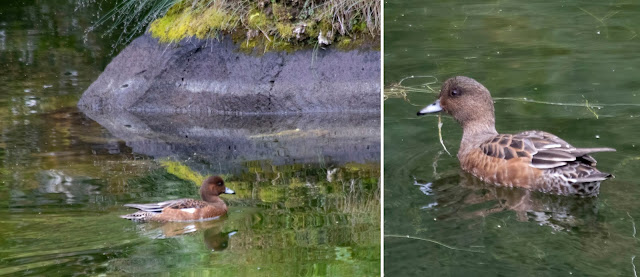 |
| Eurasian Wigeons |
Ásbyrgi’s perfect horseshoe shape was said to have been created by the stomping of one of the hoofs of the eight-legged steed of Odin. I didn’t get to see it from above.
 |
| You can see the horseshoe-shaped wall |
There is a trail, but the warning signs that mention narrow, slippery conditions and falling rocks (plus the fact that Scott was waiting in the car) held me back.
 |
| This part of the trail was safe |
Lots of Iceland’s attractions are advertised with aerial photos (much like Grand Prismatic Spring in Yellowstone).
 |
| Photo: Veni Vidi Amo! |
 |
| The lake from as far above as I could get |
Like Hljóðaklettar, Ásbyrgi was most likely formed by catastrophic glacial flooding.
 |
| The lake |
Rain!
After Ásbyrgi, we had planned to reach Raufarhöfn by driving up the west side of the Melrakkaslétta Peninsula, around the top and then down to town.
But, the skies opened. It rained and rained. And, Scott was not interested in any sight-seeing, so we drove across the base of the Peninsula and up the east side to Raufarhöfn.
 |
| Not as delightful as we hoped |
 |
| Raufarhöfn from a hillside |
Once home to largest herring export harbor in Iceland, the population has shrunk to 188 and the buildings have gotten a bit rusty (that’s literal; many buildings, including homes, in Iceland are clad in corrugated metal).
The hotel itself was a large, square metal building reached by a serrated metal staircase (the kind that prevents falls when icy but is super-scary to walk on). It was a bit daunting. But, the room was large – if a bit old-fashioned. And, the restaurant was quite good.
 |
| Hotel Nordurljos dining room; Photo: Booking.com |
 |
| Grimsey Island; Photo: Arctic Trip |
Second, Raufarhöfn is allegedly a great place for aurora viewing because it faces northeast out to open ocean.
 |
| We didn't get aurora, but we did get sunset on Melrakkaslétta |
 |
| A bird blind on Melrakkaslétta |
And, fourth, Arctic Henge.
Arctic Henge
How I didn’t know about Arctic Henge before we got there, I do not know. It’s cheesy, but striking as well.
 |
| Construction is not yet complete, but what is done is impressive |
 |
| Photo: Scott Stevens |
Started in 1996, Arctic Henge is a monument to Iceland’s Nordic roots as well as a potential gathering spot for people who have embraced neo-pagan beliefs in recent years (think harmonic convergence in Sedona).
When we visited, we saw only a few other people and they were leaving (or camping in the parking lot).
So, we walked around in the mist by ourselves. That is probably much more impactful than visiting with a crowd on a sunny day.
 |
| A modern pagan structure |
Inspired by a poem called Völuspá (Prophecy of the Seeress), Arctic Henge will eventually have 72 small blocks encircling four larger stone monuments, which in turn will surround a central balanced column of massive basalt blocks.
 |
| A model of the proposed structure (in the lobby of our hotel); Photo: Scott Stevens |
Each part of the layout corresponds to some aspect of ancient Norse belief; the 72 blocks will represent 72 dwarves who embody the seasons in the world of the poem. Their names will be inscribed on the rocks.
 |
| Multiple views |
When Arctic Henge is complete, visitors will be able to "capture the midnight sun" by viewing it through the various formations at different vantage points depending on the season. Of course, we had little sun, but we were able to capture a sunset ...
 |
| Perhaps the prettiest time; Photo: Scott Stevens |
... and the Moon ...
 |
| Too bad there was no aurora |
Exploring
We did as much exploring in the area as the weather and light would permit.
 |
| Scott taking a photograph |
We drove north to the tip of Melrakkaslétta (and northernmost point on Iceland’s mainland).
We also poked a little around town, including visiting a restored 1928 church was built by Guðjón Samúelsson, one of the most important Icelandic architects, and the church's accompanying graveyard.
 |
| A pretty church |
 |
| Raufarhöfn Lighthouse |
Plus, there was the small orange Raufarhöfn Lighthouse and the larger white Hraunhafnartangi Lighthouse at the top of the Peninsula.
Icelandic lighthouses have such an interesting look: very utilitarian and somewhat Art Deco. There are approximately 104 of them along the country's 3,100 miles of coastline.
 |
| Hraunhafnartangi Lighthouse |
 |
| Two things to see in Raufarhöfn; Photo: Scott Stevens |
We saw quite a few, including a whole group running through town.
 |
| An early morning roundup; Photo: Scott Stevens |
Scott even tried feeding them carrots. They don’t like carrots.
 |
| Trying to make friends |
Melrakkaslétta was a birding wonder. Too bad it was so dark.
 |
| Graylag Geese taking off |
I saw Common Redshanks …
 |
| Admiring his reflection |
Lots and lots of Graylag Geese ...
 |
| Geese taking off |
Lots and lots …
| Geese in a field |
 |
| More Geese in a field |
 |
| A juvenile Black-headed Gull |
Eurasian Oystercatchers, both walking …
 |
| This one had multiple bands |
... and flying ...
 |
| Flying and landing (this one was not banded) |
Black Guillemots ...
 |
| Three juveniles on the water (I suspect the adults had already gone out to sea) |
Eurasian Wigeons ...
 |
| Also becoming a common bird |
Sanderlings …
 |
| I love these tiny critters |
Black-tailed Godwits …
 |
| My first successful (kind of ) photo of Black-tailed Godwits |
Common Loons …
 |
| We didn't see many of these |
And, can you believe it? Another Gyrfalcon.
 |
| Two! This was a treat (despite severe overcast and a late-in-the-day sighting) |
This one was a brown morph and most likely a juvenile. Two Gyrfalcons when I expected to see none!!!
We also encountered this scene on a marshy island. Lots of sticks decorated with colorful gloves and some kind of nesting platform.
 |
| This was puzzling |
 |
| Common Eiders |
It was a Common Eider nesting area. The stakes and gloves help locals know where they can gather eiderdown and eggs – and helps scare predators away.
Trip date: August 13-September 1, 2021
No comments:
Post a Comment