|
| Me at Theodore Roosevelt National Park |
Our next stop was Theodore Roosevelt National Park, which is located in
western North Dakota. The 70,446-acre park has three sections: The North Unit,
the South Unit and the Elkhorn Ranch Unit; we visited North and South, starting
with North.
 |
| Teddy Roosevelt in North Dakota, 1883 |
The only American National Park named directly after a single
person, the park honors 26th U.S. President Theodore Roosevelt. He was the founder
of the country's National Parks and started the conservation movement in the U.S. He credited his time in North Dakota as being the inspiration for those actions.
When the young, wealthy Roosevelt came to the North Dakota
badlands to hunt bison in 1883, he fell in love with the rugged lifestyle and
the "perfect freedom" of the West. Apparently, he really dug into the western life, despite his "dandy" clothes.
He invested $14,000 in the Maltese
Cross Ranch seven miles south of Medora, living occasionally in the “Maltese
Cross” cabin, which has been relocated to just behind the South Unit Visitors
Center.
 |
| Maltese Cross cabin |
The next year, 24-year-old Roosevelt, who was serving in the New York
Assembly, suffered a devastating loss when his wife died giving birth to their
daughter and his mother died of typhoid fever within a few hours of each other
on Valentine’s Day. Leaving his infant with his sister, he returned to his
North Dakota ranch seeking solitude and time to heal.
 |
| Elkhorn Ranch |
That summer, he started
his second ranch, the Elkhorn Ranch, 35 miles north of Medora (we didn't go there because the roads are supposed to be pretty bad after a heavy rain and it had rained the night before). Roosevelt wrote extensively about his experiences in the west and had articles published in eastern newspapers and
magazines. He also wrote three books about his life in the west: Ranch Life and
the Hunting Trail, Hunting Trips of a Ranchman and The Wilderness Hunter. His
adventures in "the strenuous life" outdoors and the loss of his
cattle in the starvation winter in 1886-1887 were influential in his pursuit of
conservation policies as President of the United States from 1901 to 1909.
 |
| Maltese Cross Cabin moving to its current site in 1959 |
Following Roosevelt's death in 1919, the Little Missouri
Badlands were explored to determine possible park sites.
The Civilian Conservation
Corps established camps there from 1934 to 1941 to develop roads and other
structures, which are still in use today.
The area was designated the Roosevelt Recreation
Demonstration Area in 1935 and, in 1946, it was transferred to the U.S. Fish
and Wildlife Service as the Theodore Roosevelt National Wildlife Refuge.
President Harry Truman established the Theodore Roosevelt National Memorial
Park in 1947, the only National Memorial Park ever established.
In 1978, in
addition to boundary adjustments and the establishment of 29,920 acres of the
Theodore Roosevelt Wilderness, the Park's designation was changed to Theodore
Roosevelt National Park.
 |
| Theodore Roosevelt National Park |
Theodore Roosevelt National Park -- North Unit
Scenic drives in both Units wind around a wide variety of bare rock hills, some featuring a wide array of colors and fantastic rock formations. We started in the North Unit.
 |
| Strata of sediments, including coal seams |
Particularly interesting are the “cannonball concretions.” A
concretion is a hard, compact mass of matter, often ovoid or spherical, formed
by the precipitation of mineral cement within sedimentary rock or soil – often
around a foreign object such as a leaf, shell or even a man-made item.
 |
| Cannonball concretions |
Concretions form within layers of sedimentary strata that have already been deposited, usually before the rest of the sediment is hardened into rock. The concretions are harder and more resistant to weathering than the host stratum.
 |
| Caty and the concretions |
Because of the variety of unusual shapes, sizes and compositions, concretions have been interpreted to be dinosaur eggs, animal and plant fossils, extraterrestrial debris or human artifacts.
The ones at Theodore Roosevelt look a lot like giant bowling balls.
Concretions vary in shape, hardness and size, ranging from
objects that require a magnifying lens to be seen to huge bodies weighing
several thousand pounds. Some of the giant, red concretions in Theodore
Roosevelt National Park are almost 9.8 feet in diameter.
While we were taking pictures of the concretions, we had to
wait while two women scrambled all over the delicate rock structures. I cannot
understand why people just have to disobey the rules and climb on cliffs, across
waterfalls or in any other places that are supposed to be protected from human
destruction. Plus, while they are doing it, we had to wait to take pictures.
Ugh! Sometimes I want to be a ranger.
Another really interesting feature in the North Unit is the blue
bentonitic clay flows that color some of the valleys. The calcium bentonite is formed from the
weathering of volcanic ash and is really striking from the overlook.
 |
| Strata of bentonitic clay |
We also noticed what appeared to be a petrified tree – a fact
that we confirmed the next day when we visited the South Unit.
 |
| Petrified tree |
The rock throughout the park is very porous and unstable -- one of the main reasons that climbing on the formations is prohibited. Of course, none of these parks have enough rangers, so prohibitions aren't enforced.
 |
| Watch out! |
In
fact, the ground shifts so much that the North Unit Visitor Center had to be
rebuilt and then torn down again because of instability. The current
“temporary” North Unit Visitor Center is in a trailer. It seems that, with the
ground issues, a trailer might be the best choice. In many places, the road
also heaves and dips because the soft underbed.
Although Theodore Roosevelt is considered great for wildlife
viewing, we didn’t see a lot in the North Unit. We didn’t see any large Bison
herds, but we did encounter a few of the big beasts along the roadway.
 |
| American Bison taking his time on the road |
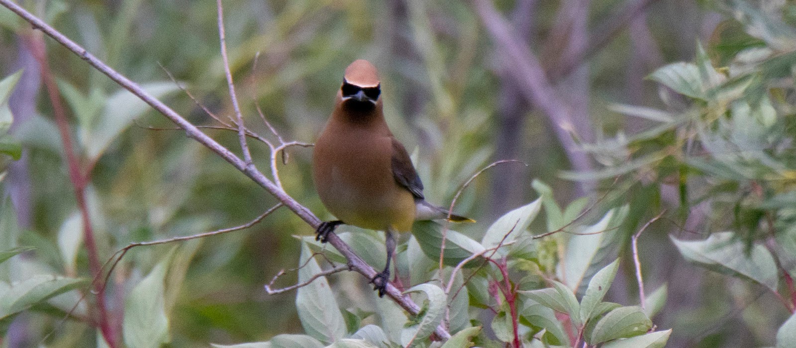
And, we saw
a wide variety of birds in one little spot along a creek. That included lots of Cedar Waxwings …
 |
| The superhero of birds |
A Red-headed Woodpecker …
 |
| This was a nice find |
American Robins …
 |
| An underappreciated bird |
Eastern Kingbirds …
 |
| An Eastern Kingbird in the Midwest |
A Wild Turkey ...
 |
| Hiding in the grass |
And a Common Grackle …
 |
| Loud, but pretty |
Fortunately, in the South Unit, which I will get to later,
we did see lots of the big mammals for which the park is famous. The entire park
has been surrounded with a seven-foot tall woven wire fence to keep Bison and Feral Horses inside the park and commercial livestock out. Other animals are
able to pass over, under, or through the fence in specific locations provided
for that purpose.
 |
| American Bison |
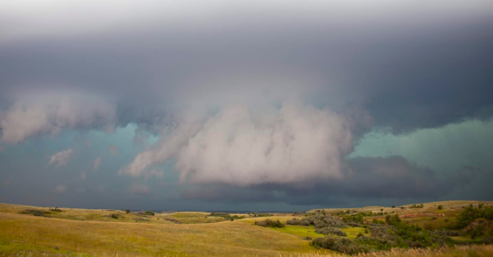
When we stopped at the Little Missouri River Overlook, a
woman told us that she had just gotten a warning about an approaching severe
thunderstorm and, indeed, there were dark clouds forming in the distance.
Initially, we couldn’t tell if the storm was coming our way. But, after a
while, we decided that we should head north to Watford City, where we were
staying for the night.
 |
| Threatening |
As we were driving out, the storm started to build. First,
we had some really good views of the leading edge …
 |
| The most spectacular storm I have ever seen (a bit scary, too) |
And, then the anvil-shaped storm cell …
 |
| And, it kept getting more dramatic |
We had to pull over just to get some pictures. That was a
bit dicey because giant semis kept barreling by, literally rocking the car as
they passed. Then it started to rain – hard. We plugged along, flashers engaged,
going about 20 miles an hour as we drove through the worst of the storm.
Finally, it let up a little and we made it to our hotel. Later, we found out
that the tornado sirens had been blaring all during the storm.
 |
| Not (quite) as bad as it looked |
It turns out that there wasn’t a tornado that afternoon. But, a week earlier, a tornado had touched down in town for four full minutes, killing a
baby, destroying 122 structures and damaging 200 more.
Because of the
curvature of the earth, North Dakota has some serious gaps in its weather radar
systems, making it much more difficult to confirm rotation below 10,000 feet. I
am sure the town is much more cautious since the killer tornado.
I was surprised by Watford City. Somehow, I expected it to
be the kind of small tourist town you see near a National Park. Nope – that
would be Medora by the South Unit. Watford City is a full-scale oil town. The
12th largest city in North Dakota, some of its streets are gravel
(including the street our hotel was on). There are lots of oil wells and flare
stacks (those constantly burning flames you see in all oil drilling areas),
numerous trailer parks that I assume are part-time housing for oil workers and
plenty of rustic bars.
Knife River Indian Villages National Historic Site
The next day instead of driving straight down to the South Unit, we detoured about 80 miles to visit Knife River Indian Villages National Historic Site, which preserves the historic and archaeological remnants of bands of Hidatsa Northern Plains Indians.
 |
| Earth Lodge and Visitor Center, Knife River Indian Villages National Historic Site |
A major trading and agricultural crossroads at the confluence of the
Knife and Missouri Rivers, the area was home to three villages: Awatixa Xi'e, Awatixa
and Big Hidatsa. Awatixa Xi'e is believed to be the oldest; Big Hidatsa was
established around 1600.
 |
| Hidatsa village along the Knife River painted by George Catlin in 1810 |
Knife River Indian Villages National Historical Site
features visible remains of earth-lodge dwellings, cache pits and travois
trails plus a restoration of a lodge, similar to the “permanent” ones the local
tribes occupied during the summer.
 |
| Reconstructed earth lodge |
During the winter, they moved just a short
distance away to the banks of the river where they had more protection for the
high winds and driving snow common in North Dakota in the winter. The winter lodges were far less sturdy and had to be built each season.
 |
| Knife River |
The earth lodges were as large as 40 feet in diameter and
could house up to 20 families, a few horses and dogs. Horses were kept inside to prevent them from being stolen by competing Lakota Souix tribes.
Built of a cottonwood frame, covered with dirt and sod, the lodges were held together by plants that grew on the surface. They had both internal and
external cache pits for storing food to sustain the people through the winter. When the dwellings were abandoned, the walls and roofs collapsed, creating visible outer circular rim where each lodge had stood. The remains of the
earth-lodge dwellings can be seen as large circular depressions in the ground.
 |
Site of former earth lodges |
Sakakawea (Sacagawea) of Lewis and Clark fame lived in one
of the villages of the Knife River.
The Knife River Villages traded with other tribes in an area
that stretched from Minnesota to the Great Plains to the Gulf Coast and to the
Northwest Pacific Coast. Products included furs, guns, metals such as copper,
corn and other agricultural products.
 |
| Mandan village along the Knife River painted by George Catlin in 1810 |
The Knife River villages thrived until 1837, when a series
of smallpox outbreaks killed half of the
population. Gradually, survivors migrated north and developed the nearby village of
Like-a-Fishhook, which was inhabited from 1845 until the mid-1880s. The site of Like-a-Fishhook Village was lost when the construction of Garrison Dam flooded the area to create Lake Sakakawea in 1954.
Over the hundreds of years that the Native Americans
occupied the Knife River area, the landscape was mixed prairie with a minimal number of trees. The fertile floodplains were cleared and used to
cultivate corn, beans, squash and sunflowers. In addition to farming, the
natives hunted bison.
Today the land is much more forested.
 |
| Prairie grasses |
Two major things changed the terrain: decimation of the huge Bison herds that kept plant growth in check by grazing and trampling the ground; and modern efforts to suppress and control wildfires that routinely swept the land, preventing anything but quick-growing grass from taking hold.
Where grasses once grew, trees moved in and the area became more forested.
In 1974, the area surrounding the park was transformed back
to how it originally looked when the Native Americans occupied the area. The
area now contains native short grass prairies, exotic grasslands, 450 acres of
hardwood forest, cultural village sites, wetland areas and sandbars.
As with everywhere else, the park struggles with exotic
invasive plant species. Exotic plants first appeared – some accidentally and some deliberately – when Native Americans and Euro-Americans cleared the forests. The
park is currently conducting an inventory and monitoring program to gather
information on the plant and animal species present within the park and to help
them decide how to manage the exotic invasive plants.
 |
| Local flora |
We didn't see a lot of wildlife, except an Eastern Bumblebee with interesting "pollen buckets" on its legs and a Cottontail Rabbit munching on the abundant grass.
 |
| Eastern Bumblebee and Cottontail Rabbit |
The pollen basket or corbicula is part of the tibia on the hind legs of some species of bees. They use the structure in harvesting pollen and carrying it to the nest or hive. The corbicula is a polished cavity surrounded by a fringe of hairs, into which the bee collects the pollen by moistening the forelegs with its tongue and brushing the pollen that has collected on its head, body and forward appendages to the hind legs. The pollen is transferred to the pollen comb on the hind legs and then combed, pressed, compacted and transferred to the corbicula on the outside surface of the tibia of the hind legs.
Caty and I visited the lodge and walked along the path past
the remains of the villages to the riverside. We spoke for a while with an
interpretive ranger working in the (very smoky) lodge.
 |
| Inside the earth lodge |
It was a very peaceful
and interesting visit. We expected a little more structures and activities, but
it was quite nice.
 |
| Sod and plants keep the lodge sturdy |
 |
| Photo: Caty Stevens |
Theodore Roosevelt National Park -- Painted Canyon and the South Unit
And, then it was back to Theodore Roosevelt
National Park. We didn't get gas near Knife River, figuring that we'd get some later. That was a mistake. First, gas stations are few and far between and, second, we had a serious headwind that greatly decreased my gas mileage. I was showing 27 miles to go when I finally found a gas station. It was a bit tense, especially when our Google Maps routing took us down a dirt road to get to the Interstate. But, we made it!
We started with a short stop at the Painted Canyon Overlook and then went on the South Unit.
 |
| Painted Canyon |
We drove the 36-mile South Unit scenic loop twice in two days, getting to enjoy both afternoon and morning light.
Along the route, we saw a lot of the geology of the area. The landscape, primarily composed of bentonite clay, is
easily eroded by wind and water, creating a rugged system of buttes and canyons
that look wrinkled when viewed up close.
The Little Missouri River is also constantly changing. It
meanders within its banks, changing course over the years. It enlarges with
spring run-off and after big thunderstorms, barely trickling during the heat of
summer and freezing solid in the winter. The constant erosion of the surrounding
landscape keeps the river muddy most of the time (in fact that descriptor is used so
often that you might think the river’s name is the Muddy Little Missouri).
 |
| Little Missouri River in the North Unit |
During the Paleocene Epoch, the western half of North
America buckled and folded to create the Rocky Mountains. Water, wind and
freezing temperatures broke down the emerging mountains, creating large amounts
of sediment that was carried off the eastern slopes by ancient rivers and
deposited downstream in layers. Volcanoes across the west spewed huge amounts
of ash, some accumulating in standing water. Over time, the sediments turned
into sandstone, siltstone and mudstone layers that are now exposed in the Park
and the ash layers became bentonite clay.
 |
| Scenic Loop view |
Deposition from the mountains in the west continued
throughout much of the Eocene, Oligocene and Miocene epochs. Then as the
Pliocene Epoch began, erosion began to strip layers away. Rivers meandering through
broad, shallow valleys across the western Dakotas and eastern Montana plains
changed their courses many times. When the Pliocene Epoch ended about two
million years ago, one of these rivers was in almost the same position as the
modern Little Missouri River. This river flowed northward to merge first with
the ancestral Yellowstone River near Williston, North Dakota, and then merged
with the Missouri River, continuing northeastward through Saskatchewan and
Manitoba to Hudson Bay.
In the Pleistocene Epoch about two million years ago, great continental ice sheets advanced southward from present-day Canada and reached as far as the upper North Unit of the Park. The ice blocked the flow of the north-flowing rivers, forcing them to create new courses eastward and southward that emptied into the Mississippi River. The Little Missouri's new course was steeper and faster, cutting deeply through the soft sedimentary rocks and carving the broken topography that is today's badlands.
 |
| Coal veins run through the butte in the foreground |
The North Dakota badlands contain a wealth of fossil
information including bands of lignite coal and petrified trees plus fossils of
freshwater clams, snails, crocodiles, alligators, turtles and champsosaurs. This
indicates that the Park was once on the eastern edge of a flat, swampy area
covered with rivers that fanned out into a broad, sea-level delta. The region
contained dense forests of sequoia, bald cypress, magnolia and other
water-loving trees growing in or near the shallow waters.
 |
| Painted Canyon |
Leaves and branches fell into swamps and formed a dense
layer of peat, which was then compacted into a soft, woody-textured coal called
lignite. When Theodore Roosevelt lived in the badlands in the 1880s, he and his
ranch hands shoveled lignite coal from the hillsides to use in their stove.
These exposed coal veins can actually be ignited by lightning strikes or
wildfires and burn for many years, baking the surrounding rock and forming red,
brick-like porcelanite (locally called scoria or clinker) that is more
resistant to erosion. Over time, erosion has worn down the less resistant
rocks, leaving knobs, ridges and buttes topped with durable red scoria caps.
 |
| Scoria-topped buttes |
 |
| Eroded hillside |
Geologic processes continue to shape the badlands.
Rain, although infrequent, usually comes in heavy, erosive downpours like the one we drove through on our way to Watford City. Water flowing downslope forms gullies.
Rain also soaks into clay-rich rocks and
soils. The added weight sometimes causes portions of hillsides to
break loose and flow downhill. That's why the North Visitor Center is now in a trailer.
Before the advent of the white man, the Dakotas were home to
massive herds of American Bison, the largest mammal on the North American
continent.
 |
| Bison herd |
Paleontologists have traced the much-larger ancestors of the
American Bison to southern Asia 400,000 years ago. Bison made their way to
America by crossing the land bridge that once connected Asia with North
America. They moved south and east, at one time ranging from Mexico to southern
New England.
 |
| Bison skulls in the 1880s |
The greatest concentration was found on the Great Plains, where an
estimated 60 million bison once roamed.
Unfortunately, white hunters mowed them down -- wantonly and wastefully -- by the millions. It destroyed the herds and the way of life for many of the Plains Native Peoples.
If not for the foresight of a few individuals including Theodore
Roosevelt, the American Bison could have become extinct. Attempts to protect
the bison came as early as 1776, but it was not until 1894 that the first
federal legislation protecting these animals was enacted.
Killing Bison became
punishable by a $1000 fine or imprisonment, and the law was strictly enforced. With
passage of the Bison protection law, game preserves were established that
ensured their survival. Today, more than 500,000 bison live in North America
under both public and private ownership.
 |
| Bison herd |
In 1956, 29 bison were brought from Fort Niobrara National
Wildlife Refuge in Nebraska and released in the South Unit of Theodore
Roosevelt National Park. Here they roamed freely on 46,000 acres of Park land
and, by 1962, the herd had increased to 145 animals. That year, 10 bulls and 10
cows were relocated to the 24,000-acre North Unit. Although the Park can support
larger herds, park management has set herd size at approximately 200 to 400
animals for the South Unit and 100 to 300 for the North Unit to maintain
healthy range conditions.
 |
| Males have massive heads |
Full-grown Bison bulls weigh up to 2,000 pounds and stand
six feet or more at the shoulder. Their huge heads are covered with thick wiry fur. They have a shoulder hump that gives the bison its
characteristic top-heavy look, the hips being much smaller in relation to the
rest of the body.
A Bison cow is similar in appearance to the bull, but is
smaller in size, with and smaller head, weighing up to 1,100 pounds and
reaching a height of up to five feet at the shoulder. Both sexes have horns.
 |
| Female, left, and male |
Cow groups usually consist of 20-60 animals composed of
cows, bulls under three years and a few old bulls. Led by an older cow, the
group will travel 10-15 miles each day moving at a speed of 5-6 miles per hour.
Most bulls live alone or in bachelor groups of up to 20 animals. Bulls tend to
become more solitary with age.
 |
| Resting in a Prairie Dog town |
Calves are orange-red in color and are up and moving within three hours of birth. They stay very close to their mother for the first few weeks,
eventually venturing farther away to play with other youngsters in nursery
groups. At three months, the orange-red coloration starts to change to dark
brown and the hump and horns begin to form. Calves remain with their mothers
for about a year or until another calf is born.
 |
| Calf lying down for a nap |
Bison are herbivores, feeding primarily on grasses. They are
often seen in or near Prairie Dog towns where they find a continual supply of
new grass shoots and can wallow in the loose soil. They reach maturity at seven
or eight years and may live more than 30 years. Wolves and grizzly bears are their
natural predators, but neither exist in Theodore Roosevelt National Park.
 |
| Actual sign in South Dakota -- choose correctly! |
Oh, and yes, the name is BISON. Not BUFFALO.
That stupid "Home on the Range" song ruined it for everyone by calling Bison buffalo and Pronghorn antelope.
Forget that!
"Bison" is a Greek word meaning ox-like animal, while "buffalo "originated with the French fur trappers who called these massive beasts bœufs, meaning ox or bullock—so both names, bison and buffalo, have a similar meaning. The Bison is actually only distantly related to the true Buffalo, which live in Asia and Africa.
 |
| Roadblock |
We saw quite a few Bison in the South Unit.
We also saw a number of Feral Horses. Unlike horses we have
seen elsewhere that have a distinctive “wild” look, these look pretty much like
any domestic horse, albeit a bit less well-groomed.
 |
| Feral Horses were muddy and scruffy |
Throughout the late 1800s and early 1900s, cowboys in the badlands captured horses (probably from Lakota herds) for use as ranch or rodeo
stock. Before the Park was established in 1947, they grazed their livestock
there.
 |
| Feral horses, including a foal |
A round-up in 1954 collected about 200 branded animals, but
some horses eluded capture, several of
which were thought to be the descendants of horses that had run free in the area
since the turn of the century.
This may explain why some of the Feral Horses in
the Park resemble horses depicted in drawings and photographs from the 1800s.
The local horses of that era were typically large-headed, short-backed and a
bit larger than the mustang of the southern Plains. They were often blue or red
roans, many having white faces and patches of white on their sides. This color
pattern, called an "apron," may be familiar from the paintings of
Frederic Remington and C.M. Russell, but is seldom seen in modern horses.
 |
| Theodore Roosevelt Feral Horses are stocky and large |
For many years the National Park Service attempted to remove
all the Feral Horses from the Park but reversed the policy in 1970 when they decided
the horses were part of the historical setting.
 |
| Feral Horse |
Feral Horses typically range in small bands of 5-15 animals,
each with an established social hierarchy, consisting of a dominant stallion,
his mares and their offspring. Frequently a subdominant stallion will "run
second" to the leader. Young stallions roam together in bachelor groups,
sometimes in proximity to a stallion harem.
Another cool sighting was a juvenile Bald Eagle soaring over
one of Theodore Roosevelt’s many large Prairie Dog towns.
 |
| Juvenile Bald Eagle |
We had gotten a bird list from the Park that noted
that, although Bald Eagles were suspected in the area, none had been confirmed.
I don’t know how old that information is, but I emailed the Park after I got
home to inform them of the sighting. I heard back that Eagles have now become commonplace and that the list needed to be updated. I suspected as much, but was kind of hoping we had a monumental sighting.
 |
| Black-Tailed Prairie Dog |
Speaking of Prairie Dogs -- specifically Black-Tailed Prairie Dogs -- they are everywhere in Theodore Roosevelt.
They once ranged the Great Plains from southern Saskatchewan to northern Mexico and were named "petits chiens," or "little dogs," by early French explorers.
Black-tailed Prairie Dogs are rodents closely related to ground squirrels, chipmunks, woodchucks and marmots. They average 14 to 17 inches in length and weigh 1 to 3 pounds. With short, muscular legs and long-nailed toes on their front and hind feet, they are well equipped for a burrowing lifestyle.
A Prairie Cog colony or "town" consists of a large number of closely spaced burrows, an elaborate network of tunnels and multiple entrance holes that provide escape routes from pursuing predators. The primary prairie dog social unit is the "coterie," an acre or so of territory with 50 to 60 burrow entrances that is occupied by a single family group of one adult male, several adult females and their offspring.
Members of a coterie are a closely knit group, recognizing each other by an identifying kiss or sniff. Their cooperatively raise young, construct burrows, groom, play and defend their territory. The dominant male is typically the most active defender, patrolling borders and challenging all comers. Prairie dogs warn of territorial trespassers or approaching danger by emitting a series of "barks," which sound more like high-pitched squeaks. Specific threats are associated with distinctive vocalization patterns that serve to alert all residents of a town to the common threat.
 |
| Black-Tailed Prairie Dog chases off a Killdeer |
Prairie Dogs feed primarily on plants, which quickly disappear from the town, giving it a barren and overgrazed appearance. This closely-cropped terrain promotes easier social contacts and enables the Prairie Dogs to better spot approaching danger.
Prairie Dogs build up large stores of body fat to carry them through fall and winter. because, unlike most other members of their family, Black-Tailed Prairie Dogs do not hibernate.
 |
| Black-Tailed Prairie Dogs |
Like the Bison, the Black-Tailed Prairie Dog was once a major component of Great Plains life. Vast prairie dog towns stretched for miles across the open plains. In 1901, scientists surveyed a single Texas "dog town" that covered an area of 25,000 square miles and contained an estimated 400,000,000 Prairie Dogs. But, convinced that Prairie Dogs were destroying rangelands and competing with cattle for food ranchers virtually eradicated the Prairie Dog and many of its predators, chief among them the Black-Footed Ferret. Formerly the Prairie Dog's most dangerous enemy, Ferret numbers have only recently been raised through captive breeding programs to a level where small populations are now being released back into the wild.
 |
Medora Musical
|
Medora Musical We had only one misstep on our trip -- a quick decision we
made when we checked into our hotel in Medora, the little tourist town outside the South Unit entrance. The clerk asked if we had
tickets to the Medora Musical, which is a big deal in this little tourist town.
The description she painted was of a musical centered on Theodore Roosevelt’s
life and the history of the area. I got a little suspicious when she said it
was a “Branson, Missouri-type show in the beautiful Burning Hills Amphitheater.”
 |
| Medora Musical |
The show was starting in 30 minutes, so instead of having a nice dinner and thinking
it over, I plopped down 90 bucks for two tickets. I figured that it would be
mildly entertaining and that, at least we would have a nice view of the sunset.
It was awful. There was no Theodore Roosevelt story (turns
out that that is a different show). It was country songs and line dancing mixed
bad Hee Haw-like humor and even worse skits. I think the cast struck out at Disney
and cruise ship auditions and ended up in North Dakota.
Caty got it right when
she said that it would have been great had it been a junior high show. We left
at intermission.
I almost said that it might be good if you had children, but I really can't think of a group it would appeal to, except maybe relatives of the performers.
Plus, the set blocked the view of the hills so we couldn't really even enjoy the sunset.
A little blip in an otherwise perfect trip.
 |
| Theodore Roosevelt National Park |
The next morning, after our second drive, we headed off to
South Dakota and Badlands National Park. That’s the next post …
 |
| Badlands National Park |
Trip date: July 20-25, 2018