 |
| Great variety |
 |
| The route |
 |
| Redwing and European Golden Plover; we saw a fairy large number of both |
So, we set out, driving almost due south along Hrútafjörður, the fjord at the base of Húnaflói.
Along the way, we noticed a number of people fishing, a sight you don't see that often in the rest of Iceland.
 |
| This guy was excited; photo: Scott Stevens |
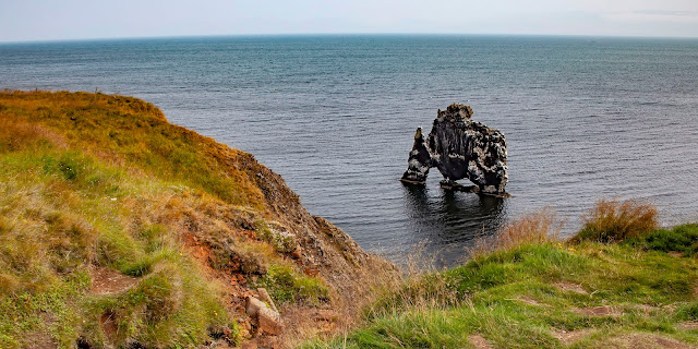
Hvítserkur
I gotta admit that, somehow, in my preparation for visiting Iceland, I had never heard of this 50-foot-tall basalt stack that sits in the ocean along the eastern shore of the Vatnsnes peninsula.
 |
| The "beast" we were chasing |
So, I didn’t know exactly what to expect, except that we were looking for a formation that resembles a giant beast drinking from the sea. The pictures were intriguing, but, when we got “there,” all we found was a parking lot. This sucker is big and it is out in the ocean. We should be able to see it from a distance. Right?
Not so much.
 |
| A landscape that speaks to a violent beginning |
We looked in one direction and saw an interesting black beach that was obviously formed through volcanic eruption, but no Hvítserkur.
 |
| You can see nothing from the trail |
It had gotten windy (very windy!) and was threatening rain. It looked like our attempt to hike to the volcano Fagradalsfjall all over again. We almost didn’t go, but we had just driven all that way. We agreed to walk a short way and see if any clues emerged.
Turns out we didn’t have to walk far at all to see over the cliff that was blocking our view. I am glad we went. It’s pretty spectacular.
And, even though you know it’s rock, you would swear you’re looking at a big buffalo or maybe a Bantha from Star Wars.
 |
| Definitely worth the walk |
Interestingly, the formation’s name, Hvítserkur, has nothing to do with looking like a sea monster. It means "white shirt" in Icelandic, a nod to the bright white guano that coats it, thanks to the Kittiwakes and Northern Fulmars that nest and perch on it.
 |
| The birds that call Hvítserkur home (and, boy, do they call!) |
 |
| Trolls in Reykjavik |
Like almost all large rocks in Iceland, Hvítserkur is often referred to as a troll. In this case, a troll that was determined to rip the bells down from Þingeyraklaustur convent (note: trolls, unlike elves, are said to be terrified of Christianity). As also happens in almost every Icelandic rock/troll tale, the beast did not notice the rising sun and was instantly petrified.
 |
| Did he take a drink at sunrise? |
Trolls never learn!
When Iceland converted to Christianity in 1000, people were allowed (wink, wink) to continue practicing the Old Norse religion in privacy.
But, over time, those who continued to follow "pagan" gods were ostracised and/or punished.
These abundant tales of trolls and troll mishaps were probably most likely just metaphors for the people's stoic resistance to Christianity, implying that those who held onto old views were as stubborn, stupid and wicked as Trolls.
Hvítserkur was actually formed by sea water carving three large holes through a basalt rock. Because erosion continues, the base of the stack has been reinforced with concrete.
On the way back down the peninsula, we drove by Borgarviki, a volcanic plug that forms a natural fortress and has been used since the age of the Sagas as an actual fortress. By now, it was quite windy and, frankly, Borgarviki looked like many other formations we had seen. So, we continued on.
 |
| Borgarviki is a natural fortress that was used in combat centuiries ago |
 |
| A few small mounds |
In fact, I had planned to spend all day driving a northern detour that has been described as breathtaking, but Scott wanted to continue along the faster Hringvegur to our cabin in Akureyri. So, we skipped it. From the descriptions, I suspect it was similar to parts of Vestfirðir, which most people driving the Hringvegur don’t get to see.
 |
| It was scenic even without taking the scenic route |
Akureyri
Our cabin near Akureyri – Vacation Home Fagravik – was really great.
 |
| Scott likes it |
Cute with a full kitchen, private hot tub and ...
 |
| And, we checked in and out with no human contact |
... a field full of Icelandic Horses right out our front door ...
 |
| If this isn't Iceland, what is? |
 |
| Two-tone horse |
In Iceland, you could generally throw a rock in any direction and expect to hit an Icelandic Horse (I don’t recommend doing that because they are lovely, gentle creatures), but we hadn’t seen any in a while.
Now that we were in Norðurland, they were everywhere – a trend that continued pretty much throughout the rest of the trip.
I have written about Icelandic Horses before, so I won’t say much except that they are Horses, not Ponies, descended from sturdy steeds imported to the island by Vikings.
They are so treasured that Iceland allows no other Horses on the island to protect them from disease and prevent any interbreeding. In fact, Icelandic Horses that leave Iceland are not even allowed to return.
 |
| I wouldn't call myself a "horse person," but I love these guys |
They come in all kinds of color combinations and seem to vary a bit in size, as well, although all are rather short and stout.
 |
| "Sailing" by Jon Gunnar Arnason |
We spent two nights at Vacation Home Fagravik and drove through Akureyri several times, but we didn’t really explore much of the town except to photograph a pretty steel statue beside the fjord (this one is Eyjafjörður) in town and a stop at the grocery store.
Dubbed the "Capital of North Iceland," Akureyri is Iceland's fourth-largest municipality and the largest town outside the country’s heavily populated southwest corner. A pretty town, it was clean and green with pretty water views. More than any other city in Iceland, it reminded me of Norway.
 |
| This building on the main thoroughfare had a Scandinavian look |
On the west side of the inland end of Eyjafjörður, Akureyri is surrounded by mountains, the highest being Kerling at 5,046 feet. There used to be several spits of land jutting from the coast, but most have eroded away except for the largest spit, Oddeyri, which was formed by the river Glerá, which runs through the town.
 |
| Our cabin looked across the water to town |
The water between Oddeyri and the end of the fjord is called Pollurinn ("the pool") and is known for calm winds and a good natural harbor. Because of the town's position at the head of a long fjord surrounded by high mountains, the climate is more typically inland than coastal, with greater variations in temperature (warmer summers, colder winters) than in many other inhabited parts of Iceland.
 |
| A farm outside of town |
However, the mountains shield the town from strong winds. The area around Akureyri has one of the warmest climates in Iceland, even though it is only 62 miles from the Arctic Circle. Therefore, botanical gardens flourish without greenhouses and the town has the most northerly 18-hole golf course in the world.
 |
| Eyrarland Statue, circa 1000 AD |
In the 17th century, Danish merchants based their summer trading camps there.
Permanent settlement at Akureyri started in 1778 and, eight years later, the town was granted its municipal charter by the King of Denmark and Iceland. The king hoped to improve the living conditions of Icelanders by creating urban areas in a wholly agricultural area.
When Akureyri did not grow from its population of 12, it lost its municipal status in 1836. Then, it regained its charter in 1862 and started to grow because of its ice-free port and the productive agricultural region around it.
 |
| Early Akureyri; Photo: Guide to Iceland |
 |
| Commercial fishing boat |
 |
| Akureyri; Photo: Guide to Iceland |
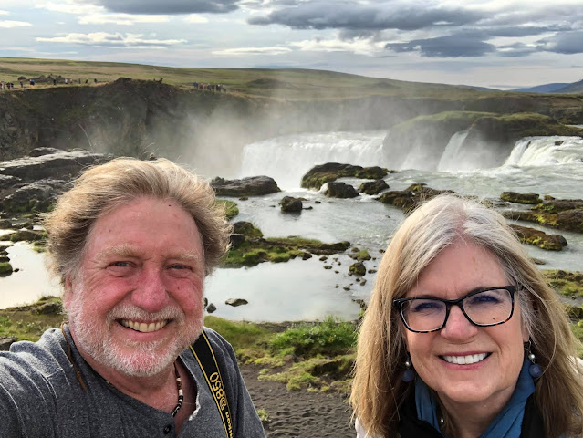
Goðafoss
The one thing I had booked was a whale watch out of Húsavík with Gentle Giants for the morning after our arrival in Akureyri. We left early enough to make a morning stop at the next famous Icelandic waterfall on our agenda. And, I must say, that was a brilliant stop because we got to see the magnificent Goðafoss in beautiful morning light.
 |
| This is a gorgeous waterfall |
 |
| Changing light gives different looks |
We ended up visiting Goðafoss three times while in Norðurland. That way, we could see the falls in different light conditions. The first stop had spectacular morning light with the added advantage of almost no other tourists.
 |
| This was empty in the morning |
Later in the day, the parking lots (there are two) were both more full. There were quite a few tour buses, as well.
Goðafoss is one of Iceland's major tourist destinations. But, still, it wasn't terribly crowded.
There are parts of Iceland that get busy, but crowds are never huge. But, with COVID still a threat (albeit much lower in Iceland), we appreciated small crowds. And, of course, for photography, the fewer the people, the better.
The lovely turquoise River Skjálfandafljót plummets about 40 feet into a canyon as it travels toward the sea, creating, perhaps, Iceland’s most beautiful waterfall (that is saying a lot because Iceland has many beautiful waterfalls).
 |
| The River Skjálfandafljót above the falls |
 |
| A nice footbridge crosses the river |
After the initial falls, the river twists and turns and then creates a smaller, lower fall called Geitafoss. There are viewing areas with paved walkways on both sides of the river connected by a nice footbridge over the lower river.
| Left, Scott taking a photo; Right, above the falls |
It’s an easy walk from one side to the other.
 |
| The river flows rapidly after the falls |
From what I have read, much of the viewing areas are new. It used to be much trickier to get to both sides.
What makes Goðafoss so special is that the almost 100-foot-wide falls form an almost perfect semi-circle flanked by cliffs ...
 |
| A perfect semi-circle |
... some with smaller streams of water flowing down them.
 |
| A small side cascade next to the main falls |
The name Goðafoss means either "waterfall of the gods" or "waterfall of the priest or chieftain;" no one knows for sure. One suggestion is that the name derives from two crags at the falls that resemble pagan idols.
 |
| Can you see the idols? |
Goðafoss has historical significance in Iceland – or so the story goes. The majority of Iceland’s early settlers in the 9th and 10th centuries were Norwegians who followed the Old Norse religion, worshipping deities including Thor, Odin, Loki and Freya.
 |
| Icelanders are Norse |
The issue was discussed at Þingvellir, where the parliament (the world's first) met once a year. The "lawspeaker" at the time, the Ásatrú priest (or goði) Þorgeir Ljósvetningagoði, had to make the decision. After praying to the Old Gods, he decided that it would be best for the country to take Christianity as the official religion, but Pagans could practice in private.
To symbolize his decision, he is said to have returned to his home in Norðurland to throw idols of the Old Gods into a beautiful waterfall.
 |
| I wonder if the idols are still in the river |
Since then, it was known as Goðafoss.
 |
| Goðafoss selfie |
Whale Watching in Húsavík
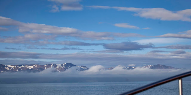
After our first encounter with Goðafoss, we hurried on up a road heading north from Hringvegur to the pretty fishing town of Húsavík on the shores of Skjálfandi Bay. The day was gorgeous and we were anticipating a fabulous whale watch.
 |
| A beautiful day in Húsavík; Photo: Scott Stevens |
With 2,307 inhabitants, the town is famous for its wooden church, Húsavíkurkirkja, built in 1907, and for its whales.
 |
| The church (back left) overlooks the harbor |
Húsavík was the first place in Iceland to be settled by a Norseman; the Swedish Viking Garðar Svavarsson stayed there for one winter around 870 A.D. and left behind a man named Náttfari and two slaves, a man and a woman, who established a farm.
 |
| The Bay from both sides |
Húsavík means "bay of houses," probably referring to Garðar's homestead, which may have held the only houses in Iceland at the time. Húsavík is now a whale watching center because a variety of different species of whales frequently enter the bay.
Or so they say. That wasn't our experience. In fact, our experience with Gentle Giants was such a letdown, despite the spectacular weather.
 |
| You could see when you looked up |
The people who took that position never moved, so any view from the front was blocked for most people.
Second, the boat was way too crowded. I think it would have violated every Coast Guard rule in the U.S. Had we encountered a problem, I doubt that there would have been many survivors.
 |
| A fellow boat, equally packed |
And, on a less hysterical level, the sheer number of people made it impossible to move around to improve your viewing vantage point. You were basically stuck in the tiny area you carved out for yourself when you boarded.
Third, when we did see a whale (we saw one Humpback), instead of maintaining a distance (as is required in the U.S.) and turning the side of the boat toward the Whale so that a large number of people could see, the captain turned the front of the boat toward the whale and rushed up close as possible every time it surfaced.
 |
| The lone Humpback of the day |
Every. Single. Time.
 |
| Rushing the poor beast |
Most of the time, we were too close for me to use my long lens. From a distance point of view, the captain seemed to be catering to the masses who want to photograph whales with a cell phone.
 |
| Too close for my lens |
 |
| It did fluke up (raise its tail as it dove) a few times |
And, finally, despite the Humpback Whale doing nothing particularly interesting – it was just swimming around and making shallow dives, most without even fluking – we stayed on and watched it for an interminable amount of time.
I am used to whale watches that stay with a Whale for awhile and then move on if the Whale is boring to try to find something else. It’s good for the participants and it’s good for the whales.
When we finally turned away (because maybe there was something on the other side of the bay), we quickly ran out of time and had to head back to the dock.
 |
| The scenery as we headed out in the Bay |
It was a waste of a beautiful morning and my dreams of seeing a Sperm Whale (or maybe getting a decent photo of a Minke) were dashed.
 |
| The harbor |
Oh, well. It was a pretty day.
 |
| A European Widgeon (a lifer!) enjoying the sunshine |
And, there was more to see.
So, we took off for another one of Iceland’s famous waterfalls, Dettifoss.
Dettifoss
I was surprised to learn that Dettifoss is located in Vatnajökull National Park because I was familiar with the Park from the southern coast. It turns out that the Park is huge, occupying most of southeastern Iceland with northern unit that encompasses Dettifoss.
 |
| Looking down on the famous falls from the eastern trail; Photo: Scott Stevens |
You can reach the falls from the east or the west (although traveling between the two is a lengthy drive). We went from the east, where you walk about a quarter mile up and then down a rocky path that looks somewhat like something from a sci-fi movie (indeed, Dettifoss was featured in the movie Prometheus).
 |
| Scott takes the trail to Dettifoss |
 |
| The surrounding landscape is eerie |
The trail from the west is about 2.2 miles long and I believe the viewing area there is less developed. It appears that you have to pick your way across rocks to reach the edge of the falls.
The second most powerful waterfall in Europe after the Rhine Falls, Dettifoss is strikingly different than Goðafoss.
 |
| Sheer power |
 |
| The water is murky |
With its grayish water, it isn’t what I would call pretty. The pretty morning had devolved into a drizzly afternoon and the sky was dark, so I am sure that made the water look duller, but all pictures I have seen and all descriptions I have read reference the huge amounts of debris the falls carry.
Dettifoss is situated on the Jökulsá á Fjöllum river, which flows from the Vatnajökull glacier and collects water from a large area in Northeast Iceland. The falls are 330 feet wide and have a drop of 144 feet to Jökulsárgljúfur canyon.
 |
| Dettifoss means "collapsing waterfall" |
What Dettifoss lacks in beauty, it makes up for in intensity. I have never seen a faster moving waterfall (and, this video is in slow motion).
 |
| It's a damp and loud walk |
The volume of water crashing over the precipice is jaw-dropping.
The spray can drench you when the wind shifts. I barely made it to the viewing platform. And, don’t even try to have a conversation over the roaring water.
 |
| Selfoss |
There is a smaller, but very pretty fall just upstream from Dettifoss called Selfoss that you can see from the trail. Selfoss means "seal waterfall," but I doubt that there are any seals in that river.
Dettifoss was the most crowded place we had seen in days (not counting the whale watch), but that was most likely because it was later in the day on a Sunday.
As we headed back to town, we encountered a large flock of Whimbrels, a cool shorebird with a long, curved beak.
 |
| There were probably 40 Whimbrels flying along the road |
Mývatn
On our way back to Akureyri, we drove a loop around Mývatn (we would be staying there in a day, but we wanted to check it out anyway) and tried to find some birds.
 |
| Mývatn means "lake of midges;" the bugs make visiting difficult |
 |
| It's a dramatic landscape |
A shallow lake situated not far from the active Krafla volcano, Mývatn is Iceland's fourth-largest body of water, with an area of 22 square miles. Dominated by volcanic formations, including lava pillars, the area around the lake was shaped by a large basaltic lava eruption 2,300 years ago that flowed down the valley to the Arctic Ocean about 30 miles away.
The lava passed over a large lake where Mývatn now sits and trapped water-logged lake sediment underneath it. Steam explosions then tore the lava into small pieces and threw them – along with some of the lake – into the air.
 |
| Photo: Vilhelm Gunnarsson, Iceland Magazine |
The area then filled with water, creating the modern-day lake.
 |
| A pseudocrater becomes an island |
 |
| A great environment for birds |
Mývatn is shallow, with an average depth of eight feet and a maximum depth of 15 feet. Fed by nutrient-rich spring water, the lake has an "abundance of aquatic insects" that are a plentiful food supply for ducks.
After we had planned the trip, I learned that Mývatn means “lake of midges." It is an apt name. The bugs were in thick clouds everywhere. They kept us in the car part of the time and forced me to pull out the mosquito head nets I had packed after I read up on Mývatn.
 |
| It was late season, so the lake wasn't full of ducks |
Mývatn is a popular birding spot. Fifteen species of ducks breed at Mývatn. It's the largest such number in Europe and includes a mixture of both European and North American species, boreal and arctic.
Most of the ducks are migratory, arriving in late April to early May from northwestern Europe. Many had already moved on when we arrived, but I did see some Tufted Ducks …
 |
| A common European duck |
Mallards …
 |
| Found everywhere, I think |
Gadwalls …
 |
| Very pretty in flight |
And, Eurasian Widgeons ...
 |
| Well, that was hardly 15 species! |
Bird populations have been monitored annually since 1975 by the Mývatn Research Station. Iceland has a long tradition of harvesting duck eggs for home use on the local farms. To ensure sustainability, harvesters follow strict rules of leaving at least four eggs in a nest for the duck to incubate.
Back Home
After poking around Mývatn, we headed back to Akureyri, knowing we’d be back in the same area the next day. Back “home” at our cabin, we did a little exploring. We discovered that there were whale watching companies just down the road, so I guess we didn’t need to go to Húsavík (but, the town was lovely).
We encountered a beautiful church, one of many cream-colored, red-roofed churches – primarily Lutheran – all over the country. Many are in areas so remote it is hard to imagine that they can scrabble together a congregation.
 |
| At least in Akureyri, there are enough people for a congregation |
 |
| Our resident horses; Photos: Scott Stevens |
Trip date: August 13-September 1, 2021
No comments:
Post a Comment