 |
| El Malpais National Monument |
 |
| Cliffs and lava are the Park's big draws |
The name is from the Spanish word for "badlands" and it references the massive volcanic field that covers much of the Park's area.
 |
| The lava stretches as far as the eye can see |
The rugged pahoēhoē and ʻaʻā lava flows, cinder cones, lava tubes and other volcanic features are part of the Zuni-Bandera volcanic field, the second largest volcanic field in the Basin and Range Province of northwestern New Mexico.
 |
| I am always amazed that you can still see the flow of ancient lava |
The Park sits on the southeast margin of the Colorado Plateau at the intersection of the Rio Grande Rift Basin between the high mesas of the Acoma Pueblo to the east, Mt. Taylor to the north and the Zuni Mountain anticline to the northwest.
 |
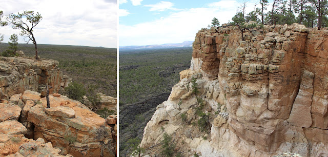
| An unobstructed view across the basin |
You can really observe the confluence of two different environments here: giant sandstone cliffs intersect with the lava flow.
 |
| A good illustration of the two worlds |
El Malpais also boasts La Ventana ("the window"), a large natural arch.
 |
| La Ventana |
Some of the oldest Rocky Mountain Douglas-firs on Earth can be found in El Malpais.
 |
| My hike passed lots of living and dead trees, many twisted and gnarled |
The area around El Malpais provided resources for early indigenous peoples and was traversed by Spanish colonial and American pioneers.
 |
| A tough place to traverse |
In the 1940s the Malpais lava field was one of the eight candidate sites considered by the Manhattan Project to test detonate the first atomic bomb. White Sands Proving Ground to the south was ultimately selected. The Department of Defense used the Park area as a bombing range to train pilots during World War II.
After the war, the Bureau of Land Management became the administrator of the area. In 1987, President Reagan signed the law that created El Malpais National Monument and designated it a unit of the National Park Service.
 |
| Another beautiful place (New Mexico is full of them) |
The Park is now jointly managed with El Morro National Monument by the National Park Service and the Bureau of Land Management. BLM manages quite a few National Monuments, many that you never hear anything about. It is on the Trails of the Ancients Byway, one of the designated New Mexico Scenic Byways.
 |
| And, scenic it is |
The weather was still dicey -- and super windy -- so I did some short hikes (up the mesa) and sightseeing, but didn't stray too far from the protection of my car. This area looks like it could get crazy during a storm.
 |
| I wouldn't want to get caught out here |
Trip Date: June 7-13, 2014
No comments:
Post a Comment