 |
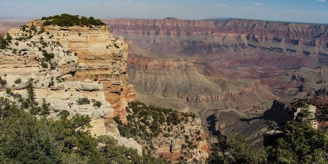
| The gorgeous North Rim |
Finally, I made it to the North Rim of the Grand Canyon shortly after noon.
Although the main part of the Grand Canyon is only 10 miles wide, getting to the North Rim is not easy. It's pretty isolated and is a 215-mile drive from the South Rim. Therefore, it is not nearly as crowded as the South Rim.
 |
| Solitude and beauty |
Of course, I was coming from the other direction, but it is still a long drive.
At over 8,000 feet in altitude, it is cooler and has a view that not only includes the Canyon, but also includes the plains to the south and the San Francisco Peaks near Flagstaff.
 |
| Those little bumps on the horizon are massive mountains about 80 miles away |
It was smoky because of fires in Arizona, but if you look closely at the pictures you can see the peaks in the distance.
 |
| Smoky horizon |
The first surprise was just after I entered the park -- a herd of American Bison!
 |
| I didn't know the Grand Canyon had Bison |
 |
| Buffalo Jones |
But, each year fewer Bison return to House Rock Valley and some are not leaving GCNP at all. Because of the impact they are having on the very fragile region, they may be moved back to House Rock Valley.
I had not been to the North Rim since Mark and I hiked the South Rim in 2005 and I haven't stayed there since Scott did the rim-to-rim in 1985. So, I was excited to get a cute little duplex cabin very convenient to the lodge and the rim. Why I can't ever remember to take my own pictures of my accommodations, I don't know. Anyway, it was lovely (except paper-thin walls).
 |
| Photos: TripAdvisor, left; and, right, wikimedia.com |
Once I was settled, I explored, taking in the lovely sights ...
 |
| That's the Colorado River through the window in the middle |
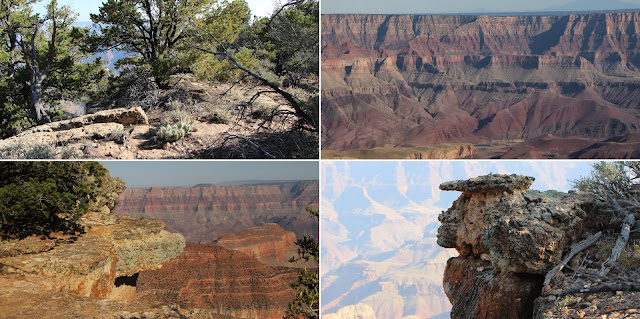
Cliff Springs Hike
I then did a short hike to Cliff Springs -- just a mile round-trip, but quite beautiful.
 |
| The overhang is so low, I had to duck in some areas |
Because it was a very green side canyon, quite different from all my other Grand Canyon experiences. As the name suggests, the trail goes along a cliff ...
 |
| Right along the edge |
... to an alcove where water continually drips from the ceiling, forming a few shallow pools and supporting an area of moss, ferns and other green plants.
 |
| The green against the red is striking |
Cape Final Hike
Then, I went back to the rim of the main Canyon and hiked to Cape Final for some additional gorgeous views.
 |
| Sounds ominous |
My car and my phone had different times. So I asked a fellow hiker what time it was. He gave me a great quote -- "Native Americans think the white man is crazy for thinking a day is like a blanket that could make longer by cutting a strip off one end and attaching it to the other." Then, he told me the time and I set my watch.
I had to really book it it to complete the hike in time.
But it was worth it.
 |
| Does the lower right look like a woman? |
The views were lovely.
 |
| Does this look like a dragon or dinosaur? |
But, dinner! After practically running the 2.5 miles back to my car and rushing to the Lodge, I discovered the guy with the great quote gave me the wrong time!!! So, I had an hour to kill.
 |
| I had plenty of time to get cleaned up |
That turned out to be quite a gift because I took the paved trail ...
 |
| The north side of the Bright Angel |
... to Bright Angel Point for lovely sunset views ...
 |
| The Grand Canyon is made for sunset |
Then, to dinner. I had a delicious ribeye steak. I ate half and the rest made two more meals for me. And, then, to bed.
 |
| Time to sleep |
Hike to Roaring Springs
The next morning was serious hiking time. Originally I thought I might try to do the North Kaibab trail to the river and back.
 |
| Grand plan, but a bit overconfident |
But, then, I discovered it is a wee bit longer than I thought -- 13.7 miles one way. So, I did a "we'll go as far as makes sense and turn back" hike.
 |
| I had always wanted to hike on the North Rim |
It was a beautiful day that promised to be sunny and warm (perhaps a little too much of both). But, the morning was perfect - and the trail was very sparsely populated.
 |
| More solitude |
The first leg was about 0.7 miles and 500 feet down (of course all "down" means that I have "up" coming later) to Coconino Overlook. The trail went through a high alpine forest of aspen, douglas fir and ponderosa pine to a coconino sandstone bluff that juts out and offers fabulous views.
 |
| More beauty |
Then, on to the Supai Tunnel ... another mile and 941 feet down via switchbacks that go from white sandstone to red Supai formation rocks with lots of shade trees ...
 |
| A dramatic change in rock type |
... and, a tunnel cut in the rocks ...
 |
| Supai Tunnel |
From the Supai Tunnel to Redwall Bridge is an additional 1.4 miles and 738 feet down along a red bluff that was in morning shadow, but I knew shade would be gone by my return trip.
 |
| Left, Red Wall; right, the bridge and the trail |
After crossing the Redwall Bridge ...
 |
| It would be a tough hike without that bridge |
... I traveled another 1.6 miles and 800+ feet down to Roaring Springs ...
 |
| Looking toward the main Canyon |
Pinyons and junipers, redwall limestone, muav limestone, bright angel shale and tapeats sandstone dominate.
A waterfall signals approach to the quarter-mile offshoot trail to Roaring Springs.
 |
| My destination |
I stopped at Roaring Springs, opting not to go on to the Cottonwood Campground, because the trail appeared to even out and get less interesting. Plus, I knew I had a tough hike up.
 |
| It's all up from here |
I ate my lunch - best ever hiking lunch - bagel with cream cheese, cucumber, tomato and avocado. I ate only half plus some carrots. I didn't rest long because I wasn't sure how long the trip up would take.
 |
| The trail taking a sharp turn |
Of course, it was now close to noon and hot, so the trip up was tough. Really tough. Especially, the steep, unshaded redwall after the bridge.
I took lots of breaks up that segment.
 |
| Then it got hot -- dizzyingly hot |
I took a long break at Supai Tunnel, where I ate the rest of my lunch. I think I hadn't eaten enough and that's why that leg of the hike was so difficult. After I ate, I was fine.
 |
| Gotta get going |
Just as I was ready to finish the hike, a mule train arrived. Apparently the North Rim does mule rides to Supai. Anyway, I waited for the dust to die down before continuing.
In all, it took 8 hours and 23 minutes and I burned 1854 calories.
 |
| It felt like more! |
I celebrated with a shower and a picnic (leftover ribeye) at Imperial Point.
Then, I drove out to see the Bison herd. I wanted to try to photograph a calf I had seen when I was coming in -- black instead of the usual red - but he wasn't there. There was a Coyote stalking the herd and then howling. I suspect he was calling other coyotes to help him cull out a calf.
 |
| I saw the Coyote for just a few seconds, but I heard it for a long time |
I pointed the Coyote out to other travelers - Dutch and Italian - who were not familiar with American wildlife. I wish I knew the Italian word for Coyote (oh, it turns out to be Coyote). Anyway it was a fun pantomime. I don't think they ever understood what I was trying to say.
Anyway, it was a fabulous day.
 |
| So, so beautiful |
Trip Date: June 7-13, 2014
No comments:
Post a Comment