 |
| A beautiful side creek |
I took the road through Poudre Canyon (along the Cache la Poudre river). The river was very high, which made for some dramatic views.
 |
| Wild country |
Poudre Canyon isn't as well known as Big Thompson Canyon, but it's a spectacular drive anyone visiting Colorado should take. And, it is minutes from Caty's house.
The river's headwaters are in the Front Range in Larimer County, in the northern part of Rocky Mountain National Park. The river descends eastward in the mountains through the Roosevelt National Forest in Poudre Canyon, where it is a force to be reckoned with.
 |
| Wild river |
It emerges from the foothills north of the city of Fort Collins. It flows eastward across the plains, passing north of Greeley, and flows into the South Platte River approximately five miles east of Greeley.
The name of the river means "Hide the powder" in French, referring to an incident in the 1820s when French trappers, caught by a snowstorm, were forced to bury part of their gunpowder along the banks of the river.
 |
| Do you think they found their powder? |
I took French in high school and had been pronouncing it "cahsssh lu poudrrruh" with a rolled R on Poudre. Nope. Locals say cash lah POO-DER. It just doesn't sound as sexy that way.
It is a popular summer destination for fly fishing, whitewater rafting (scary on this river!), tubing and kayaking in the Poudre Canyon. Back in 2008, Caty and Scott set out on a rafting trip (guided, of course) and Scott had to jump out of the raft to avoid it flipping over (bad guiding). He was held briefly underwater by the raft. He got out of the river and Caty finished without him. We haven't rafted since.
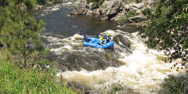 |
| Caty braves it in an almost-empty raft |
The river has been substantially populated since the 1930s by year-round residences. Nearly all of the land in the area is privately owned, including the river banks which are not public property in Colorado.
I explored some side roads, including Pingree Peak road, which looked like a potentially great place to camp.
 |
| Rolling hills and pine forest |
You could still see the scars from the fire two years ago, but the landscape is so beautiful, it isn't really that bad.
 |
| You can see dead trees on the right |
Back on the main road, I passed Poudre Falls ...
 |
| Wild falls |
... and Cameron Pass ...
 |
| A rare day when the peak isn't snow-covered |
Then, before I got to Walden, I turned off on CO-27, a dirt/gravel road from Gould to Rand. What a pretty place!
 |
| Summer in the Rockies |
Snow-capped mountains, lakes and huge fields of summer flowers.
 |
| Fences and flowers |
If the weather is good, this road is a good shortcut to Grand Lake. If the weather is bad, the road would be rough or impassable.
 |
| Beautiful |
After this pleasant little jaunt, I headed back home.
 |
| An interesting rock spine (that's natural, not a wall) |
Trip Date: June 23, 2014
No comments:
Post a Comment