 |
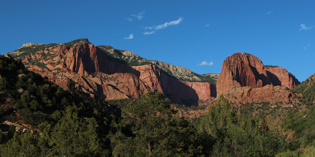
| Kolob Canyon, left, and Cedar Breaks National Monument, right |
In June, I decided to do what I said I was retiring to do -- take a spontaneous road trip. Scott was going fishing in Minnesota, so it was the perfect opportunity. I plotted a route, but was unable to secure reservations at the North Rim of the Grand Canyon, so I just planned the first few days of the trip. My plan was to make decisions based on weather and what I encountered on the trip.
My primary objectives were Cedar Breaks National Monument, one of the few major NPS sites I hadn't visited in Utah ...
 |
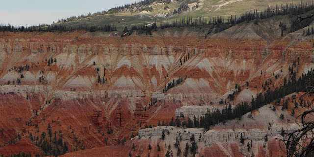
| Cedar Breaks |
... and Kolob Canyons, the western park of Zion that I had seen only briefly (and at a bad time of day for photography).
 |
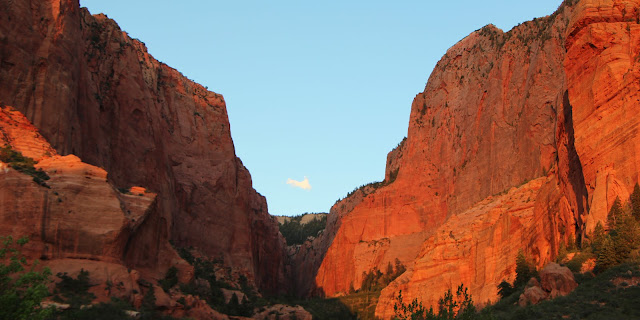
| Kolob Canyon |
I hadn't been to Cedar Breaks because, at 10,000 feet, it has two seasons - winter (which requires snowmobiles or skis) and summer (which starts when the snow melts in late May). When we tried to visit before, it still had four feet of snow.
I decided to make Cedar City, Utah, my base. So, I booked a room there for a few nights.
Before I continue, let me apologize for assuming everyone is as into National Parks as I am. I am intent on visiting them all -- and I have been to 48 out of 59. Plus, I have been to 47 National Monuments out of 99.
 |
| My National Park Passport |
You can earn about them at www.nps.gov. Well, most of them -- more on that when we get to Kasha-Katuwe!!
 |
| My route |
At one of my first stops, the Collegiate Peaks Overlook near Buena Vista, Colorado, I did something really dumb. I stopped, admired the scenery ...
 |
| Mount Princeton |
... and pulled out (marveling at how clean my back window was) and then, just after I pulled onto the highway, realized I'd left my back hatch open.
 |
| I didn't see anything behind me when I backed up |
Yikes! Luckily, I didn't lose my cooler and all my luggage. I did lose one of my beloved collapsible walking sticks. But, it could have been so much worse.
It was a beautiful drive that traveled along many streams and rivers that were raging with water after all our rains. One, outside of Leadville, was so turbulent that my windshield was splashed as I drove by.
Because I had so far to go, I didn't make many stops. The scenery near Arches National Park (great restraint on my part; I didn't stop in) is very interesting, with dramatic ridges. Unfortunately, I didn't really take many pictures.
 |
| Near Moab, Utah |
Unfortunately, I didn't really take many pictures.
 |
| But, I did take some |
I knew I was headed for some fabulous scenery.
I finally arrived in Cedar City, a very neat and tidy little tourist town. I checked into the Best Western, where they upgraded me to a ground-floor suite. Super for me because I was picnicking a lot of the time and it had a fridge, microwave, table and couch.
Just a quick aside about picniking. Several months ago, I saw a great movie called The Lunchbox, in which the metal Indian food container called a tiffin played a major role. I commented on Facebook that I wished I had a tiffin. Several days later, a big box arrived, filled with three different tiffins from my wonderful brother, Mark. I had snacks in my tiffin in the car.
 |
| My goodies, left, Irrfan Khan, in The Lunchbox (see it!), right |
Kolob Canyon
Since it was still light, I took a quick drive to Kolob Canyon, which, as I said, is part of Zion National Park. I had been to Zion several times before, but had only driven past Kolob. I was not going to the other part of Zion on this trip.
 |
| Kolob Canyon |
I knew that it would be most attractive at sunset ...
 |
| Good light, pretty plants and dramatic cliffs |
... because the entrance to the steep canyon faces directly west.
 |
| Getting some late afternoon sun |
In the afternoon, it gets fabulous light.
 |
| The Moon was already out |
On a previous trip, we had gone by in the early morning, when it was backlit. Horrible for photos.
 |
| You can see afternoon shadows forming; soon the Canyon would be dark |
Kolob Canyons is just 17 miles south of Cedar City and includes a five-mile scenic drive through narrow parallel box canyons cut into the western edge of the Colorado Plateau, forming majestic peaks and 2,000 foot cliff walls.
 |
| On the scenic drive |
As the sun sank, the cliffs got progressively redder ...
 |
| This is what it actually looked like |
... and more majestic ...
 |
| Amazing |
I stayed until it was too dark to shoot pictures.
 |
| And, then, it was over |
Then - exhausted - I returned to my room, where I was able to microwave the can of chicken noodle soup I threw in my food bag at the last minute. Perfect!
I got up early the next morning to check out my prime objective -- Cedar Breaks.
Cedar Breaks
So, on to Cedar Breaks. It's a half-mile deep geologic "amphitheater" that somewhat resembles Bryce Canyon National Park.
 |
| Self portrait at Cedar Breaks |
It contains meadows on the rim and ancient bristlecone pine trees tortured by the wind and brutal weather.
 |
| This is a harsh environment |
As far as I could tell, there are only two trails in the park (I hiked both) and none go into the amphitheater.

Cedar Breaks was made a National Monument in 1933. One of its most outstanding features is its altitude - 8,100-10,662 feet -- and its clear skies. I wanted to see the Milky Way but, as luck would have it, I was there during a very bright full moon!
As I mentioned earlier, Cedar Breaks has a very short season where it can be accessed by car. Mean monthly minimum temps are above freezing only in June, July and August and annual snowfall tops 30 feet.
 |
| No snow on this day (at least not here) |
It has lots of wildlife - including California Condors (I wanted so badly to see one) and Mountain Lions (I know not to hope for that). When I got to the summit overlook in the morning, the first thing I saw was a Yellow-bellied Marmot.
 |
| Lounging on the edge |
As you can see, the amphitheater is spectacular.
 |
| My, my, my |
I took the four-mile round-trip Ramparts Overlook hike (I saw no one else until I was returning). Not a tough trail, but the uphill is a bit taxing just because of the altitude.
| The trail |
It accesses two overlooks -- Spectra (one mile and most people's destination) ...
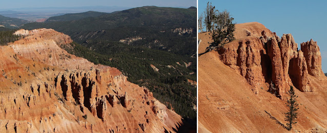 |
| Spectra |
... and Ramparts ...
 |
| Ramparts |
I was treated to a lovely walk in the woods ...
 |
| The trail goes through some trees, but is mainly on the edge |
... blue skies, ancient trees ...
 |
| Twisted, gnarled trees (I used one on the right to hold my camera for my self-portrait) |
... great vistas ...
 |
| It goes on and on |
... unbelievable views everywhere ...
 |
| Pillars |
After walking, oohing, aaahing and taking lots of pictures, I made my way back ...
 |
| I am so glad I went |
... and decided to do the second hike -- also a short one -- to Alpine Lake. The lake was pretty disappointing.
 |
| Alpine? Looks like a swamp! |
Nearby were some funky aspens. I assumed the curly trunks were caused by deep snowbanks. Later, I found out the curl is a response to unstable or shifting ground.
 |
| Interesting trunks |
I then drove around the area, including taking a long road to a mountain overlooking the park. I couldn't get to the summit, however, because snow across the road caused me to turn around (when you are by yourself, you don't take chances -- much).
 |
| Here's some snow |
I also drove to the ski resort town of Brian Head (although somehow I missed the actual town). It was quite a steep, narrow, winding road, with some grades in excess of 13 percent. Hence, no pictures.
After some exploring and picnicking, I decided to drive back up to Cedar Breaks, but was distracted by a road to the reservoir. Turned out to be a very long, partially gravel, road with some beautiful scenery, deer, wild horses, one very fast fox and some beautiful flowers.
 |
| Summer flowers |
The reservoir itself wasn't much to look at, but the far-end of the road took me into the main part of Zion on Kolob Terrace Road.
 |
| The road has great vistas |
I mentioned earlier that I don't like to take chances when I am alone (I don't really like to when I am with other people either).
 |
| A remote area |
Now, I am more careful with steep dirt roads.
I ended the long day by going to the movies -- I saw "The Fault in Our Stars" on what appeared to be date night. I think I was the only one in the theater alone and over 17!
Kolob Canyon Redux
 |
| The money shot |
And, the next morning, I headed to Kolob Canyons again, this time to hike.
 |
| I wanted to see what was in the canyon |
At a ranger's suggestion, I did Taylor Creek, participating an a ranger-led hike that went halfway and continuing on to end on my own.
 |
| The trail |
It was (as the pictures attest) a beautiful day.
 |
| Majestic! |
The trail crosses Taylor Creek 50+ times ...
 |
| The creek was just a trickle |
... fortunately, unlike Colorado, the creeks were low.
 |
| The trail uses the creek, so it must be low most of the time |
It also passed some settler's cabins.
 |
| Like so much of Utah, Mormons settled the area |
This area was settled by Mormons, hence the name, Kolob. Church Founder Joseph Smith described Kolob as the heavenly body nearest to the throne of God.
 |
| You can see why they thought it was heavenly |
While the Mormon Book of Abraham refers to Kolob as a "star," it also refers to planets as "stars," and therefore, some Mormon commentators consider Kolob to be a planet.
 |
| Was I in outer space? |
If you hike the full two and a half miles, you get a reward -- a spectacular and unusual double-arch canyon ...
 |
| Double-Arch Canyon |
... so big that you can walk in ...
 |
| I have never seen anything quite like it; this is the lower arch |
... and one above it ...
|
| The upper arch above the lower arch |
I wish I had a wider lens to capture the entire thing.
 |
| Looking up |
It is fascinating not just because of the rock formations, but also because of the mineral stains and eroded channels that create multiple colors and patterns.
 |
| Really striking |
When I arrived at the end, I took off my pack, ate my lunch (very yummy bagel, cream cheese and tomato) and then stashed my pack so I could explore. A Fox Squirrel, which was begging while I ate, almost succeeded at stealing a baggie of dried fruit. It actually unzipped the pack and had the bag halfway out!
 |
| Bad Squirrel! But smart. |
After rescuing my lunch and scolding the little varmint, I finally left and hiked back.
 |
| A sheer wall |
I took an hour-long drive that night back to Cedar Breaks in hopes of seeing the Milky Way. Too bright! All I saw was lots of Deer by the road!
I also checked online and was able to get a room (for two nights) at the Grand Canyon North Rim. The next part of my trip was planned!
 |
| Another good day! |
Trip Date: June 7-13, 2014
No comments:
Post a Comment