 |
| The Canyon wall |
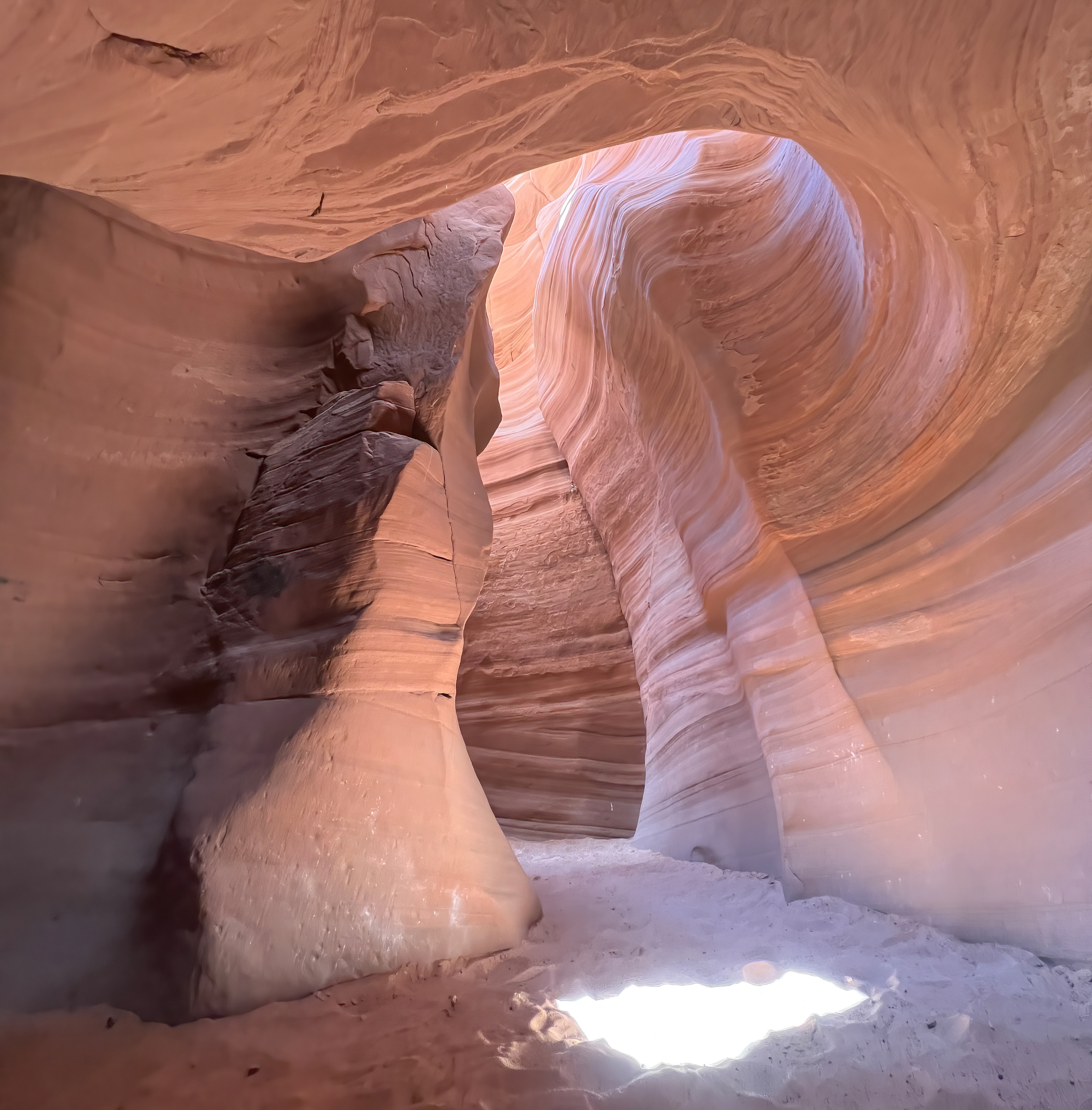
This isn’t the famous Upper and Lower Antelope Canyon you often see in photos, but it is lovely, less restrictive and easier to access.
 |
| This shows where the Canyon got its name |
Located on Navajo lands, just east of Page, Arizona, Canyon X is part of the same famous Canyon, just a bit further from town.
 |
| Can you see the woman with flowing hair? |
Maybe I shouldn’t mention the name for fear of encouraging crowds.
Caty had always wanted to see and photograph this type of slot canyon, but couldn't go with us in 2019. So, she suggested that we make a trip so that she could have this experience, as well.
Plus, she also wanted to see Horseshoe Bend and the Condors at Navajo Bridge and visit the North Rim of the Grand Canyon (I didn’t realize she hadn’t been there since she was three). So, we wrapped it all together in a June/July trip to northern Arizona.
 |
| Our planned destinations |
I know. I know. Only crazy people go to Arizona in July. But, Antelope Canyon is only open between March and October and the North Rim between May and early October. Plus, some of these areas are cooler (a tiny bit) than lots of Arizona.
And, as it turned out, we had relatively pleasant weather. The preceding weeks it had been in triple digits, sometimes approaching 120°F. We barely cracked 100°F.
After making our original plans, Caty got an extra day off, so we decided to add a night in Ouray, Colorado, on the way home to the mix.
 |
| Another pretty spot |
On the first day, we drove all the way to Page, Arizona, which sits on the edge of Lake Powell and the Glen Canyon National Recreation Area. It provides access to the huge Glen Canyon Dam, which holds back the Colorado River to form the lake.
 |
| Glen Canyon Dam |
Because of ongoing droughts, I expected the lake to be terribly low. It wasn’t (water management can be confounding!).
 |
| The water is stunning |
Because it was almost Independence Day, I expected the town to be crazy with “holiday revelers.” It was actually pretty calm.
 |
| Ahhhhh |
We stayed just the first night of the trip in Page, arriving around sunset.
 |
| Outside Antelope Canyon X |
I regret that we weren’t able to arrange a different schedule because, the way it worked out, we never got to use the hotel pool in Page. And, none of our other hotels had pools (in Arizona!).
On our way back home, we stopped again in Page so that we could go to the Glen Canyon Dam Visitor Center, which had been closed when we arrived the first day.
 |
| Too late to do much |
Antelope Canyon X
The tour of the Canyon was fantastic, even better than my first visit.
 |
| Sandfall |
Because I have already written about Antelope Canyon, I won’t give any geology or history details here, just some photos and observations of this trip.
 |
| You have to look up |
We went with Taadidiin Tours (all Antelope Canyon tour companies are Navajo-owned) and took the photo tour, which costs almost three times what a regular tour costs, but it is so worth it.
 |
| So, so worth it |
There were only five people plus a guide in our group; the regular tours have about 15-20.
 |
| Passing tour with slow exposure |
We spent three hours in the Canyon; the regular tours spend less than half that amount of time.
 |
| This gave us time to explore lighting |
We were allowed tripods; regular tours can't carry much more than a water bottle and a cell phone.
 |
| The photo tour provides more time and space |
 |
| A skull formation |
So, Caty and I didn’t have to jockey (much) for tripod space. It was ideal.
We had lots of time with a virtually empty area to shoot; the regular tours don’t provide much “alone time.”
The photography tours are timed to get a good shot at the beams of light that reach the Canyon only at mid-day. Then, the guide (our guide, Nala, was superb!) throws hands full of sand into the beam to enhance to photo.
 |
| The famous "beam shot" |
This works only if you are there at the right time. We were.
 |
| Success! |
During the pandemic, all the Antelope Canyon tours had closed down and this season was a restart.
 |
| It was a tough time for the Navajo Nation; Photo: Taadidiin Tours |
Upper and Lower Antelope Canyon had not yet re-instituted photography tours, making Taadidiin an even better choice. Personally, I wouldn’t go any other way.

I noticed a few changes since pre-pandemic.
First, you used to park in a lot and be transported via van to the cave entrance.
Now, you follow a pilot car down a gravel road and park right by the Canyon, walking just a short distance down a steep hill to start the tour.
 |
| Looking toward the Canyon entrance |
I swear that the entrance process has changed, too. I think you used to go in one side (that involved a little climbing) and out the middle. Now, we went in and came out the same entrance (and had no climbing). Much better!
It was a great tour, with a somewhat dramatic ending. As we were leaving the Canyon, it started to sprinkle. By the time we reached the small covered area near the Canyon Entrance where guides relax and tours are staged, there was thunder.
 |
| It was sunny while we were in the Canyon |
The guides told us not to walk up the steep hill to our car for fear of a lightning strike. The other three people walked, but Caty and I listened to the guides and waited a few minutes for an ATV ride up the hill to our car. As we got into the ATV, we overheard that they were cancelling the afternoon tours because of the two dangers of lightning and flash flood. So, we were glad we had scheduled before noon.
 |
| A half an hour earlier, rain seemed unlikely |
The sign said to wait for a pilot car, so we waited. And, it rained. And thundered. And lightninged (not really a word, but you get it). And rained some more.
Several cars of employees came down the road (possibly to join their co-workers for lunch at the covered area). No one acknowledged us.
The rain started to collect on top of the hard ground, creating streams where none had been before. We were sitting up high in the lot, but we knew that the road dipped way down before climbing back up to the main lot and the highway. The prospect of a flash flood seemed real.
 |
| In 2006, rain filled the Canyon; Photo: photo.net |
Just as I was about to disobey the sign and make my way back to the big lot without a pilot car, an employee in a pick-up truck (not the official pilot car) came by and offered to guide us out.
We made it safely, but we could see how the situation could escalate.
We drove back to Page in heavy rain that dissipated only when we got to town. Then, it was hot and sunny again. And, we had successfully photographed the Canyon and escaped being swept away!
 |
| Another batch of great photos |
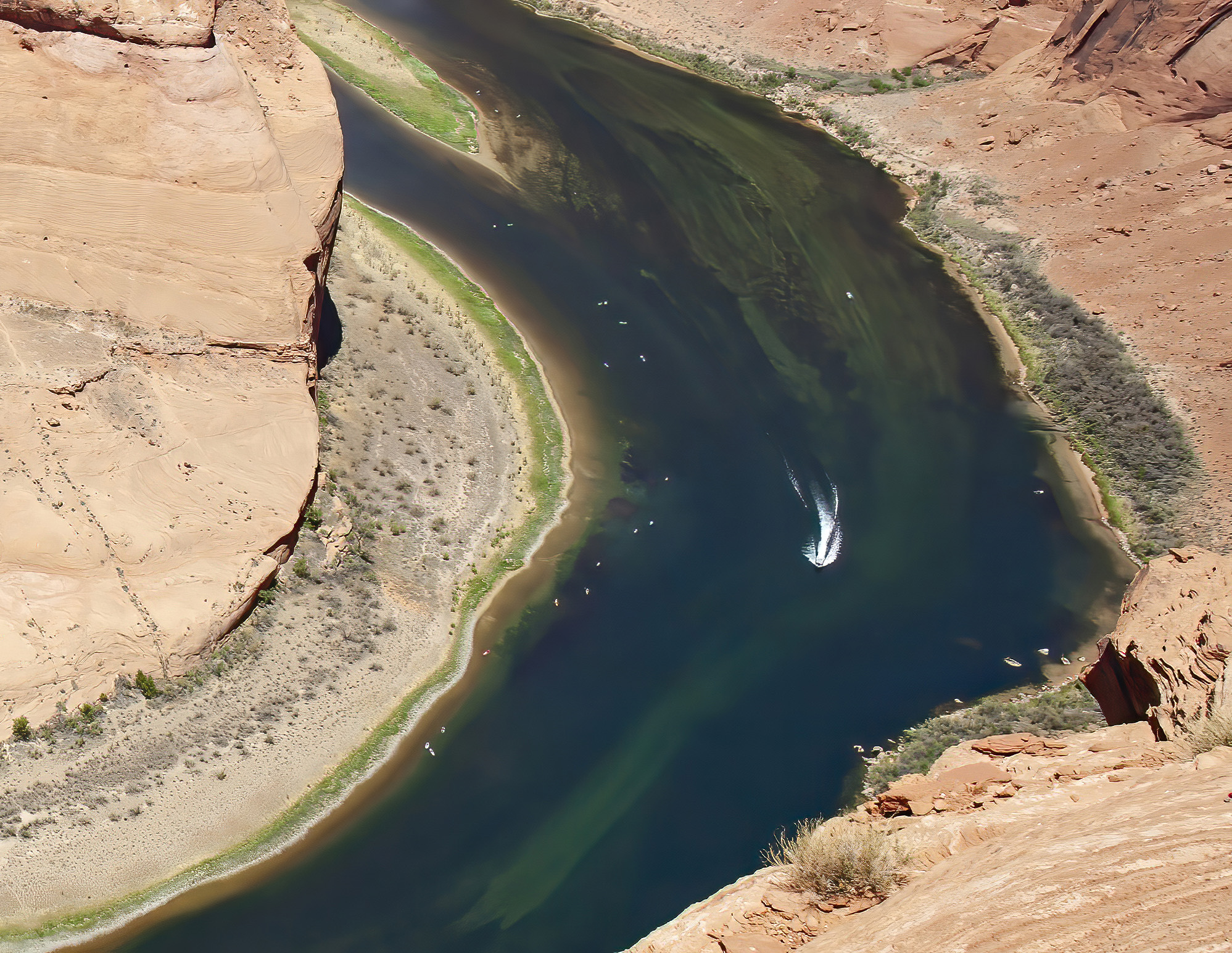
Horseshoe Bend
Another destination on this trip was Horseshoe Bend, an overlook that provides fabulous vistas of a bend in the Colorado River just below the Glen Canyon Dam that winds around the canyon wall.
 |
| Horseshoe Bend |
From the facing cliff, it looks like the river circles a butte, but aerial shots show how the river hugs the canyon wall.
 |
| Different perspective; Photo: Google Earth |
Scott and I had also been to Horseshoe Bend before without planning in advance.
 |
| Oddly, we never stopped before 2018 |
Although I am coupling this write-up with our visit to Antelope Canyon X, this is not a chronological representation of the trip.
From a travel perspective, it would have made sense to go to Horseshoe Bend immediately after Antelope Canyon before moving on to the Grand Canyon.
But, two things argued against that. First, I knew from my previous visit that the walk to the viewpoint, while not particularly long (it’s 1.5 miles round-trip) or steep (only 137 feet in loss/gain), can be hot. And, the hottest part of the day is the afternoon. Morning would be better.
 |
| You have to hike; this is all you can see from the parking lot |
Second, Caty researched it and found that the low sun creates shadow in the afternoon, potentially causing problems with photos. Morning would be better.
So, after Antelope Canyon X (and lunch in Page), we drove right by it and proceeded to the North Rim of the Grand Canyon for a two-night stay.
 |
| We'll talk about this later |
Then, we came back in the morning two days later.
It was still hot when we arrived, but not nearly as bad as it could have been. We just made sure we had water and hats and sunblock (and cameras!).
 |
| It was reasonably toasty |
When we arrived, I noticed that the parking lot had been improved with paving (I think it was gravel before) and nice entrance kiosks. Then, the path seemed better – wide, less big rocks and no ruts.
 |
| The Kiosks and trail |
 |
| Nope! |
For reasons that should be obvious, I did not do that. So, all my photos cut off part of the view.
 |
| The best view I could get the first time |
After we went, I read some pretty frightening accounts of this overhanging cliff splitting and breaking away, once even carrying a spectator to her death (not the only death that had occurred there). I was less inclined to approach the rim.
But, low and behold! After we had visited in 2018, they built a viewing platform.
With railings! With an unobstructed view!
 |
| You can see it all! |
Fabulous!
 |
| No more anxiety! |
So, we were able to get beautiful full-vista views (and photos) without having to crawl on hot rocks on our bellies. Yay!
 |
| It might be fun to take a boat trip |
You can change focal length and make slight angle changes, but not much else. It might be wise to stay for a longer time and catch changing light, especially if there are clouds.
We had clouds, but they didn't seem to change the lighting much. And, it was too hot to stay long.
I did notice that, while the morning/noon time slot didn't produce shadow, it was also brighter with less color depth than when we went in the afternoon. I'm not sure which is better.
 |
| Yikes! |
Of course, the platform hasn’t eliminated all deaths. Someone died this year after crawling over the railing. We saw lots of stupid behavior while we were there. Some people just don’t understand why railings are there!
More to Come
So, we had accomplished part of our goal and successfully visited two iconic western landscapes.
 |
| This is so Arizona |
More cool stuff is coming in the next post.
Trip date: June 29-July 5, 2022
No comments:
Post a Comment