 |
| Yosemite Valley |
Ah, Yosemite! I
both love it and hate it. Love it
because it is gorgeous beyond belief. Hate it because it is so popular, making
it impossible to book in advance and crazy crowded when you are there.
 |
| Yosemite Valley |
When I was
planning the trip, I could not find a book-in-advance campsite and, although
there are first-come-first-served sites, who wants to risk not having a spot? So, I booked a room for three nights at the Big Trees Lodge.
Now, that’s really
the Wawona Lodge, but the vendor had to change the name because the
previous concessionaire, which had lost the lodging contract with Yosemite
National Park, still held the rights to that name and all the other iconic
lodging names in the Park. That dispute has been resolved and I believe the
original names will be reinstated.
So, we had a room about an hour outside the
crowded Yosemite Valley. We were a bit sad that we couldn’t camp, but we
decided we’d make do. I’ll get to that later. First, let me talk a little about
Yosemite.
The Park
 |
| Bridalveil Fall |
Located in the
western Sierra Nevada of Central California, Yosemite is bounded on the
southeast by Sierra National Forest and on the northwest by Stanislaus National
Forest. Almost 95 percent of the 1,189-square-mile Park (roughly the size of Rhode Island) is designated wilderness.
 |
| A small crowd in the Mariposa Grove |
About 4 million people visit Yosemite each year, spending most of their time in the seven square miles of Yosemite Valley. The Park set a visitation record in 2016, surpassing 5 million. Although Yellowstone was the first National Park, Yosemite was central to the
development of the idea. President Abraham Lincoln signed initial protection into law in 1864.
John Muir led a successful
movement to have Congress establish a larger National Park by 1890, one which
encompassed the Valley and its surrounding mountains and forests, paving the
way for the National Park System.
 |
| Half Dome, left, and Vernal and Nevada Falls, right |
Yosemite has an
elevation range from 2,127 to 13,114 feet and contains five major vegetation
zones: chaparral and oak woodland, lower montane forest, upper montane forest,
subalpine zone and alpine. The Park is home to about 1,400 species of plants,
including more than 160 rare ones. The park's varied habitats support over 250
species of vertebrates, which include fish, amphibians, reptiles, birds and
mammals.
 |
| California Ground Squirrel, left, and California Sister Butterfly, right |
Yosemite contains thousands of lakes and ponds, 1,600 miles of
streams, 800 miles of hiking trails and 350 miles of roads. Two federally
designated Wild and Scenic Rivers, the Merced and the Tuolumne, begin within
Yosemite.
 |
| A quiet spot on the Merced |
About 10
million years ago, the Sierra Nevada was uplifted and then tilted to form
gentle western slopes and steep eastern slopes. The uplift increased the
steepness of stream and river beds, which then sculpted deep, narrow canyons.
About one million years ago, glaciers at the higher alpine meadows moved down
the river valleys, reaching thicknesses approaching 4,000 feet in Yosemite
Valley. The movement of the ice masses created the scenic U-shaped Valley that is
the trademark of the Park.
 |
| The Merced River snaking through Yosemite Valley |
The name
"Yosemite," which means "killer" in Miwok, originally
referred to a tribe that lived in the Valley. Previously, the area had been
called "Ahwahnee" ("big mouth") by indigenous people. The
fancy hotel in the Valley was – and probably soon will be again – named
Ahwahnee.
 |
| Ahwahnee Hotel |
Yosemite Valley
has been inhabited for nearly 3,000 years, although humans may have first
visited the area as long ago as 10,000 years. For many years, it was a major
trading area for a number of California tribes, primarily Northern Paiute,
Miwok and Mono.
The California Gold Rush in the mid-19th century dramatically brought in larger numbers of European-Americans, creating competition with the indigenous peoples for resources.
 |
| There is a historic village near Wawona |
In 1851, as part of the
Mariposa Wars intended to suppress Native American resistance, the United States Mariposa Battalion followed natives into the Valley and were “awestruck”
by its beauty. Letters and articles written by members of the Battalion
helped popularize the Valley among white tourists and artists.
The Valley’s native
inhabitants were moved to a reservation near Fresno and their village was burned.
Eventually, some were allowed to return and live within the boundaries of the
Park and many got tourism industry jobs as laborers, maids, cooks or servers.
Some also made a living by selling baskets or performing for tourists. Another great example of how the incoming white people pushed out the natives!
 |
| Early Native American baskets; Photo: NPS |
 |
| Mariposa Grove |
Tourism began in earnest in the mid-1850s and increased after the First Transcontinental Railroad was completed in 1869.
Three stagecoach roads were built in the mid-1870s to provide better access and, in 1879, the Wawona Hotel (named after the original village, which, in turn, was named after the giant sequoia trees – "Wawona" in Miwok – that grow nearby) was built to serve tourists visiting the nearby Mariposa Grove of Giant Trees. Yosemite's
first concession was established in 1884 with a bakery and store. In 1916, the
newly established National Park Service granted a 20-year concession to the
Desmond Park Service Company, which bought out or built hotels, stores, camps,
a dairy, a garage and other park services. Desmond changed its name to the
Yosemite National Park Company in December 1917.
Beginning in
1899, the Curry Company also provided concessions in the park, among them Camp
Curry, formerly known as Curry Village.
When the National Park Service decided
to limit the number of concessionaires in each National Park in 1925, the Curry
Company and the Yosemite National Park Company were forced to merge to form the
Yosemite Park & Curry Company.
In 1913, after a fair amount of opposition, Congress authorized building the O'Shaughnessy Dam in Hetch Hetchy, which I will talk about later.
 |
| O'Shaughnessy Dam |
Tuolumne Meadows Lodge, Tioga Pass Road and campgrounds at Tenaya and Merced Lakes were completed in 1916. Automobiles started to enter the park following the construction of all-weather highways to the Park.
Over the years,
the Park Service has sought to reduce negative impact on the environment. For
example, they stopped the practice called “Firefall,” in which red-hot embers
were pushed off a cliff near Glacier Point at night. This is not to be confused
with a natural “firefall” phenomenon in which sunlight hits Yosemite Falls,
making it look like it’s on fire.
 |
| Natural firefall (photo) should not be confused with man-made (brochure); Photo: CNN.com |
To deal with traffic congestion in Yosemite
Valley during the summer, the park implemented a shuttle service, using
electric buses.
Accommodations
Although he
hadn’t really talked about it in advance, Scott was eager to try some more
night photography in Yosemite. Unfortunately, the Wawona is fairly far – on
dark and winding roads – from good vantage points for getting the night sky
above Yosemite Valley.
 |
| The Big Trees/Wawona is charming, but far from Yosemite Valley |
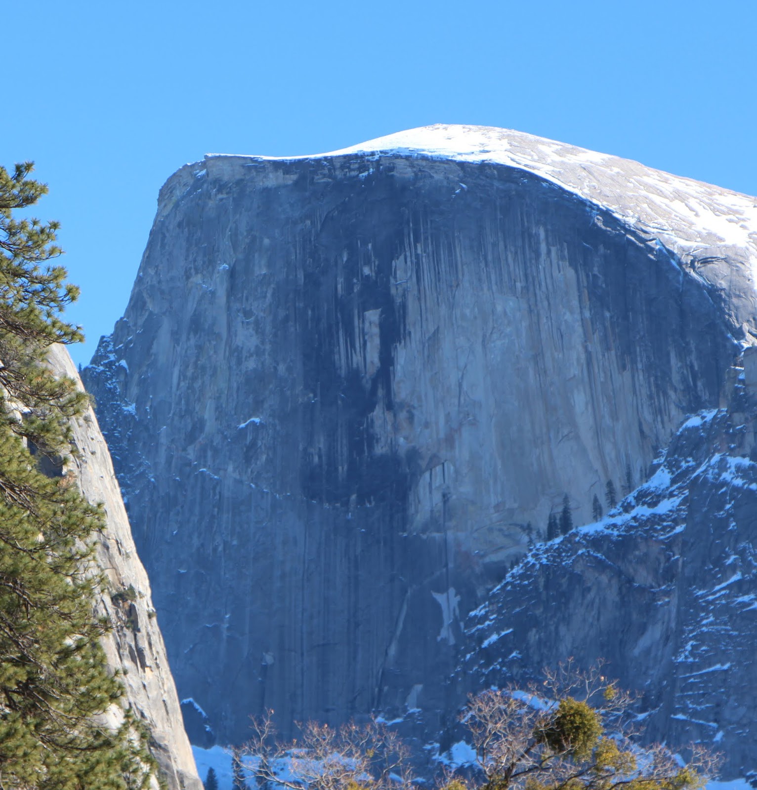
We decided that Glacier Point offered the best options for the night sky because it has some wide vistas from which you can see both El Capitan and Half
Dome, which rise 3,300 and 4,800 feet, respectively, above the Valley
floor.
 |
| El Capitan, left, and Half Dome, right |
We noticed that
there was a very pretty campground with availability on the Glacier Point road.
Hmmmmm …
 |
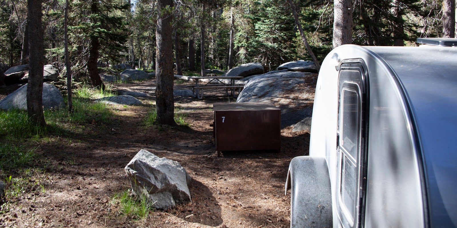
| Our campsite at Bridalveil Creek Campground |
So, even though out expensive hotel was non-refundable, we secured a
very inexpensive campsite at the Bridalveil Creek Campground where we could park the teardrop camper and get
back-and-forth to the Valley and the Valley views for night shots. Over the
next three days, we slept at the hotel only the last night and slept at the
campsite two nights.
 |
| You can't have a campfire in a hotel room; Photo: Scott Stevens |
Our room at the hotel didn’t have a private bath, but we did have
unlimited access to hot showers and the pool. So we enjoyed those amenities
while also sleeping in the outdoors. The night we did stay at the Big
Trees/Wawona, we had an actual fire alarm, although we never determined if
there was a blaze. Still, we had to evacuate and wait for the Fire Department,
which took a fair amount of time to arrive. The Big Trees/Wawona is wooden, so
a fire would have been very bad.
 |
| No peace at the inn |
As I said, the
campsite was lovely. Because of a water main issue after a recent forest fire,
this campground has no running water and no toilets except porta-potties. But,
it was so pretty. And, a Black Bear visited to check out the bear boxes while
we were there.
 |
| Campground Bear; Photo: Scott Stevens |
The number of tourists has created issues for the Black Bears in
the Park.
The bears have learned to identify coolers and break into cars, so
Park rules stipulate that food and food containers (water jugs,
pic-i-nic baskets and coolers) must be put in bear boxes in campsites and many
parking lots.
 |
| Bear box and a Bear ignoring the rules |
Sights
So, back to
night photography. We had great results with capturing the Valley at Glacier Point ...
 |
| Nighttime at Glacier Point |
... but the Milky Way was over our shoulders ...
 |
| The Milky Way from Glacier Point |
 |
| Tunnel View |
Then, the next
night, we went to Tunnel View, which offers the quintessential view of Yosemite Valley.
It was a bit farther from our campsite, but worth the winding drive (and we didn't hit any animals; a big plus).
The Milky Way was pretty high in the sky and, even late at night, there was a fair amount of traffic. When doing star photography, you have to pause every time headlights go by, so traffic is an issue. But, we still got a few nice shots.
Fortunately, the Milky Way was on display early in the evening, so we were able to get our night shots and
still be tucked into our comfy trailer by midnight.
While in Yosemite, most of our time was spent seeing – and
photographing – the sights. This included the Valley from both Glacier Point …
 |
| Glacier Point view |
… and Tunnel View …
 |
| Tunnel View view |
We were
thrilled – and I do mean thrilled – that the air was virtually smoke-free. Many
of my recent visits to Yosemite have been marred by thick smoke from nearby
forest fires.
 |
| In the summer of 2013 it was very smoky |
I believe the only exception was when I visited during January
2013 and got to see the Park in winter (fortunately the roads were clear enough
to make it there without chains!).
 |
| Winter, 2013 |
So, after taking lots of hazy shots on other trips, we were able to get some very pretty and
very clear shots of the Valley. This included Yosemite Falls
(despite huge crowds) …
 |
| Yosemite Falls |
... and Bridalveil Fall
…
 |
| Bridalveil Fall |
By the way,
Yosemite’s many sheer drop-offs, glacial steps and hanging valleys result in a
high concentration of waterfalls in a relatively small area. Generally, the
waterfalls have high volumes in April, May and June when snowmelt is high,
often dropping off or even drying out in late summer. However, while we were
there, all the falls were in full array because California had had an
uncharacteristically wet summer.
 |
| Sometimes waterfalls dry up in August; not this year |
Yosemite Falls
is the highest waterfall in North America at 2,425 feet (in two segments, the
longest of which is 1,430 feet high).
 |
| Yosemite Falls |
Bridalveil
Fall, which is the waterfall seen from Tunnel View, is 617 feet high.
 |
| Bridalveil Fall |
Vernal Falls is 318 feet high ...
 |
| Vernal Falls |
... and Nevada Falls is 594 feet high ...
 |
| Nevada Falls |
Both Vernal and Nevada Falls can be seen from Glacier Point and both were extremely robust for August. My friend Donna and I hiked to Vernal and Nevada in 2011.
 |
| Hiking with Donna |
While in the
Valley, we spent a lot of time photographing El Capitan, one of the major
rock-climbing locations in the Park. Selected as the name of the monolith by the Mariposa Battalion in 1851, El
Capitan is a loose Spanish translation of the local Miwok name for the cliff,
variously transcribed as "To-to-kon oo-lah" or
"To-tock-ah-noo-lah" and meaning "the chief" or "rock
chief.”
 |
| El Capitan's sheer face |
El Capitan is
composed almost entirely a pale, coarse-grained granite that formed
approximately 100 million years ago. A separate intrusion of igneous rock, the
Taft Granite, forms the uppermost portions of the cliff face and a third
igneous rock, diorite, is present as dark-veined intrusions through both kinds
of granite.
 |
| A gentler view of El Capitan |
Along with most
of the other rock formations of Yosemite Valley, El Capitan was carved by glaciers,
primarily during the Sherwin Glaciation, which lasted from approximately 1.3 to
1 million years ago. The El Capitan Granite is relatively free of joints, and
as a result the glacial ice did not erode the rock face as much as other, more
jointed, rocks nearby. There are more than 70 climbing routes on "El
Cap" of various difficulties and danger levels.
 |
| El Capitan climbers |
Over thirty fatalities
have been recorded between 1905 and 2018 on El Capitan, including deaths of seasoned
climbers. Critics blame a recent increase of fatalities (five deaths from 2013
to 2018) in part on “increased competition around timed ascents, social media
fame and competing for deals with equipment manufacturers or advertisers.”
We also spent a fair amount of time at both Glacier Point, enjoying view of Half Dome.
 |
| Half Dome from Glacier Point |
Half Dome is a granite dome at the eastern end of Yosemite Valley that is named for its distinct shape. One side is a sheer face while the other three sides are smooth and round, making it appear like a dome cut in half.
The impression from the valley floor that this is a round dome that has lost its northwest half is an illusion. From Washburn Point, Half Dome can be seen as a thin ridge of rock, an arête, that is oriented northeast-southwest, with its southeast side almost as steep as its northwest side except for the very top.
As late as the 1870s, Half Dome was described as "perfectly inaccessible," but today, Half Dome may be ascended in several different ways.
One is an 8.5-mile trail from the valley floor that includes several hundred feet of granite stairs and a steep final ascent aided by a pair of braided steel cables on posts.
The other approaches are rock-climbing routes from the valley up Half Dome's vertical northwest face.
 |
| Woman's face or tears? |
Half Dome was originally called "Tis-sa-ack," meaning Cleft Rock in Ahwahnechee. Or, it may be the name of a mother from a native legend; a face seen on Half Dome is supposed to be hers.
Others say the Ahwahneechee named Half Dome "Face of a Young Woman Stained with Tears" ("Tis-se'-yak") because of the brown-black lichens that form dark vertical drip-like stripes along drainage tracks in the rock faces.
We also spent time photographing from Tunnel View, enjoying the clear skies.
 |
| Tunnel View |
 |
| Giant Sequoia |
Mariposa Grove
Another place
we visited was the Mariposa Grove, the largest of the three groves of ancient
giant sequoia trees in Yosemite.
The Mariposa Grove has 200 trees, the Tuolumne Grove has 25 and
the Merced Grove has 20.
I will talk
about these magnificent trees in my next post, but I do want to comment a bit
on the Mariposa Grove.
We fell in love
with this magical place the first time we visited Yosemite back in 1981 and we
found that, if you get up early, you can (or you could back then) have the place to yourself
before the hordes of tourists descend in the afternoon.
Twice, I have been
alone in that grove with Scott.
But, growing
popularity created problems – parking, vandalism, damage to the trees’ roots,
etc. So, in 2014, the Yosemite Conservancy and the National Park Service broke
ground on a $40 million collaborative effort to restore Mariposa Grove. The Grove
closed in the spring of 2015 and re-opened last June.
The restoration,
which is, indeed, beautiful, restored the habitat and natural hydrology, realigned
roads and trails that were located in sensitive areas, constructed a welcome
plaza, relocated the parking area, added a shuttle service, added accessible
trails and removed commercial activities from the Grove such as the gift shop
and tram tours.
It was the
right thing to do for the trees, but it makes the experience of visit the trees
far less personal and more like visiting a museum. There are more fences and
railings and it is far more difficult to venture in alone. Something gained …
 |
| The changes are good for the trees |
Something lost …
 |
| Signage for Yosemite's biggest tree, the General Sherman; Photo: Scott Stevens |
Scott was
pretty disappointed, but we still both enjoyed our time in the Grove. Plus, we knew
we’d be seeing more giant sequoias at our next stop, Sequoia National Park.
We spent most
of our time in Wawona and above Yosemite Valley (which, as I recalled, was just
too crowded to spend much time in). We drove in from Mono Lake via Tuolumne,
but never made it out that way again.
 |
| Picnic on the Tuolomne Road; left Photo: Scott Stevens |
Hetch Hetchy
I did make sure we got to Hetch Hetchy, which
Caty and I had visited in the summer of 2013, but Scott had never seen.
 |
| Hetch Hetchy Reservoir |
Simultaneously
a valley, a reservoir and a water system, Hetch Hetchy is in the northwestern
part of Yosemite National Park and is drained by the Tuolumne River. For
thousands of years before the arrival of white settlers in the 1850s, the
valley was inhabited by Native Americans. During the late 19th century, the
valley was renowned for its natural beauty – often compared to that of Yosemite
Valley. But, it was also targeted for the development of water supply for
irrigation and municipal interests.
In 1923, the
O'Shaughnessy Dam was completed on the Tuolumne River, flooding the entire
valley under the Hetch Hetchy Reservoir. The dam and reservoir are the
centerpiece of the Hetch Hetchy Project, which in 1934 began to deliver water
167 miles west to San Francisco and the greater San Francisco Bay Area.
 |
| Multiple views of the dam |
Before damming,
high granite formations produced a narrow three-mile-long valley with an
average depth of 1,800 ft. and a maximum depth of more than 3,000 ft. The
valley floor consisted of roughly 1,200 acres of marshy meadows fringed by pine
forest, through which meandered the Tuolumne River and numerous tributary
streams. The valley floor often flooded in the spring when snow melt in the
high Sierra cascaded down the Tuolumne River and backed up behind the narrow
gorge now spanned by the dam. The entire valley is now flooded under an average
300 ft. of water behind the dam, creating an eight-mile-long reservoir. Some of
the valley occasionally remerges when drought hits, as it did in 1955, 1977 and
1991.
Among the
tallest waterfalls in the U.S., Wapama Falls, at 1,080 feet, and Tueeulala
Falls, at 840 feet, are both located in Hetch Hetchy Valley. Rancheria Falls is
located farther southeast, on Rancheria Creek.
 |
| Some say Hetch Hetchy is a mini-Yosemite Valley |
Hetch Hetchy
Valley began as a V-shaped river canyon cut out by the ancestral Tuolumne
River. About 1 million years ago, the extensive Sherwin glaciation widened,
deepened and straightened river valleys along the western slope of the Sierra
Nevada, including Hetch Hetchy, Yosemite Valley and Kings Canyon farther to the
south.
During the last glacial period, the Tioga Glacier formed from extensive
icefields in the upper Tuolumne River watershed; between 110,000 and 10,000
years ago, Hetch Hetchy Valley was sculpted into its present shape by repeated
advance and retreat of the ice, which also removed extensive talus deposits
that may have accumulated in the valley since the Sherwin period. At its maximum
extent, Tioga Glacier may have been 60 miles long and up to 4,000 feet thick,
filling Hetch Hetchy Valley to the brim and spilling over the sides, carving
out the present rugged plateau country to the north and southwest. When the
glacier retreated for the final time, sediment-laden meltwater deposited thick
layers of silt, forming the flat alluvial floodplain of the valley floor. Compared
with Yosemite Valley, the walls of Hetch Hetchy are smoother and rounder
because it was glaciated to a greater extent.
 |
| View from above; Photo: Scott Stevens |
The valley's
name may be derived from the Miwok word hatchhatchie, which means "edible
grasses" or "magpie." Chief Tenaya of the Yosemite Valley's
Ahwaneechee tribe claimed that Hetch Hetchy was Miwok for "Valley of the
Two Trees,” referring to a pair of yellow pines that once stood at the head of
Hetch Hetchy. Miwok names are still used for features, including Tueeulala
Fall, Wapama Fall and Kolana Rock.
While its cousin Yosemite Valley to the south had permanent Miwok settlements, Hetch Hetchy was only seasonally inhabited. This was likely because of Hetch Hetchy's penchant for flooding.
 |
| Hetch Hetchy |
Hetch Hetchy was visited by early explorers and, then, California Gold Rush prospectors. Miners didn't stay long, however, because richer deposits occurred further south along the Merced River and in the Big
Oak Flat area.
After the valley's native inhabitants were driven out by the
newcomers, it was used by ranchers, many of whom were former miners, to graze
livestock.
The valley was known for its natural beauty, but it was never a
popular tourist destination because of poor access.
Plus, the famous Yosemite Valley is just 20 miles to the south.
Those who did visit
it were enchanted by its scenery, but encountered difficulties with the
primitive conditions and, in summertime, swarms of mosquitoes.
When Yosemite
Valley became part of a state park in 1864, Hetch Hetchy received no such
designation. As the grazing of livestock damaged native plants in the Hetch
Hetchy Valley, John Muir pressed for the protection of both valleys under a
single National Park. After many disputes with ranchers, the Park’s boundaries
were finally settled in the early 1900s.
 |
| Idyllic place for a stroll |
Interest in
using the valley as a water source or reservoir dates back as far as the 1850s,
when the Tuolumne Valley Water Company proposed developing water storage there
for irrigation. By the 1880s, San Francisco was looking to Hetch Hetchy water
as a fix for its outdated and unreliable water system. The city would try
repeatedly to acquire water rights, including in 1901, 1903 and 1905, but was
continually rebuffed because of conflicts with irrigation districts that had
senior water rights on the Tuolumne River, and because of the valley's National
Park status.
San Francisco’s
1906 earthquake and subsequent fire highlighted the inadequacy of the city’s
water system, leading to a successful application for water rights in 1908 that
provoked a seven-year environmental struggle with the Sierra Club, led by John
Muir.
 |
| Dam outflow |
Because of Hetch
Hetchy’s location within Yosemite National Park, an act of Congress was needed
to authorize building a dam, which was signed in 1913 under the conditions that
power and water derived from the river could only be used for public interests.
Ultimately, the city sold hydropower from the dam to the Pacific Gas and Electric
Company (PG&E), which led to decades of legal wrangling and controversy.
Work on the
Hetch Hetchy Project began in 1914.
 |
| The tunnel goes to the trail around the reservoir |
Twenty years later the first water from the project reached San Francisco. The dam and
reservoir, combined with a series of aqueducts, tunnels, hydroelectric
plants and eight other storage dams, comprise a system known as the
Hetch Hetchy Project, which provides 80 percent of the water for 2.6
million people in the San Francisco and San Mateo, Santa Clara and Alameda
Counties.
Water from
Hetch Hetchy is some of the cleanest municipal water in the United States; San
Francisco isn’t even required by law to filter its tap water, although the
water is disinfected by ozonation and exposure to UV.
 |
| Clear water |
The water quality is high
because the upper Tuolumne River drainage basin consists mostly of bare granite
with very little sediment or organic material.
The watershed is strictly
protected; swimming and boating are prohibited at the reservoir, although
fishing is permitted at both the reservoir and the rivers that feed it.
The battle over
Hetch Hetchy Valley continues today between those who wish to retain the dam
and reservoir and those who wish to drain the reservoir and return Hetch Hetchy
Valley to its former state.
The National Park Service has said that within two
years of draining the valley, grasses would cover most of its floor and, within
10 years, clumps of cone-bearing trees and some oaks would take root. Within 50
years, vegetative cover would be complete except for exposed rocky areas. In
this unmanaged scenario, where nature is left to take hold in the valley,
eventually a forest would grow, rather than the meadow being restored. However,
the same NPS study also finds that with intensive management, an outcome in
which "the entire valley would appear much as it did before construction
of the reservoir" is feasible.
 |
| Spillway |
The dam would
not have to be completely removed; rather, it would only be necessary to cut a
hole through the base in order to drain the water and restore natural flows of
the Tuolumne River. Most of the dam would remain in place, both to avoid the costs
of demolition and removal, and to serve as a monument for the workers who built
it. The water storage provided at Hetch Hetchy could be transferred into Lake
Don Pedro lower on the Tuolumne River by raising the New Don Pedro Dam 30 ft. Furthermore,
the removal of O'Shaughnessy Dam would not require costly sediment control
measures, as would be typical on most dam removal projects, because of the high
quality of the Tuolumne River water. In the 90 years since its construction,
only 2 inches of sediment has been deposited in Hetch Hetchy Reservoir.
Opponents of
dam removal have pointed out that the flooding of the Hetch Hetchy Valley has deterred
the crowds that overrun other areas of Yosemite National Park. Hetch Hetchy is the
least visited area of the Park. Who know which way this fight will go?
We enjoyed our
drive out – including stopping to photograph wildflowers ...
 |
| Wildflowers by a historic cabin |
... and a very cooperative
Cassin’s Finch ...
 |
| Cassin's Finch |
But it was beastly hot when we got there.
Our entrance to the valley was
delayed by a pack horse train ...
 |
| NPS mules |
... but when we finally arrived in the Valley, Scott
rested in the car while I walked across the dam and through a tunnel to the
trail that eventually goes to Wapama Falls. Just a pleasant little walk.
 |
| Wapama Falls |
We missed a
turn on our way back and started down the very impressive Tuolumne River Gorge (on
a less impressive winding dirt road) before turning back to find the correct
route. On that road, we briefly saw a Black Bear run across the road and
disappear into the thick roadside shrubbery. Too quick for a photo, but a Bear
sighting!
 |
| It is easier to find Hetch Hetchy than to find your way out |
Yosemite
All in all, it
was a great visit. Clear skies ...
 |
| Half Dome dominates the view from Glacier Point |
The Milky Way ...
 |
| Straight up for a good view |
Camping while also staying in a
hotel ...
 |
| Great accommodations |
A couple of Bears ...
 |
| I didn't have much luck photographing the Bears |
Big Trees ...
 |
| Mariposa Grove of Big Trees |
Bigger waterfalls ...
 |
| Lots of water for August |
Summer flowers ...
 |
| I love purple flowers |
And all the glorious
beauty that is Yosemite ...
 |
| Can't get enough of it! |
And, even with the big daytime crowds ...
 |
| Crowds at Yosemite Falls |
... we did have a
fair amount of solitude as we traveled less visited spots at less visited
times.
Trip date: July 19-August 2, 2019


No comments:
Post a Comment