 |
| Mono Lake, California |
Another trip!
We got back
from our arctic adventure on July 4. Fifteen day later, we headed out with our
teardrop camper for another adventure. Scott has been wanting to go back to
California for several years and something has always intervened – forest
fires, other trips, forest fires, waiting too long to book, forest fires. I had
been in California on many occasions in recent years, with work or with other
people, but Scott hadn’t been there since 2012 and that was just a few spots on
the way to the San Juans. He hadn’t been to Yosemite since 1990!
 |
| Smoky skies in 2013 |
In fact, we had
cancelled a trip the year before because of forest fires. Obviously, the smoke wreaks havoc with photography.
So, this year, California
was getting above average rainfall and below average fires. We had to go. Even
if we would be just back from another trip. The idea was to
keep this fairly low-key, which we did.
The itinerary
(a little tweaked on the road) looked like this:
First night in
Great Basin National Park (this was the tweak; we drove longer to get there and
did not stay in Green River, Wyoming, as planned) ...
 |
| Great Basin National Park |
Second night in
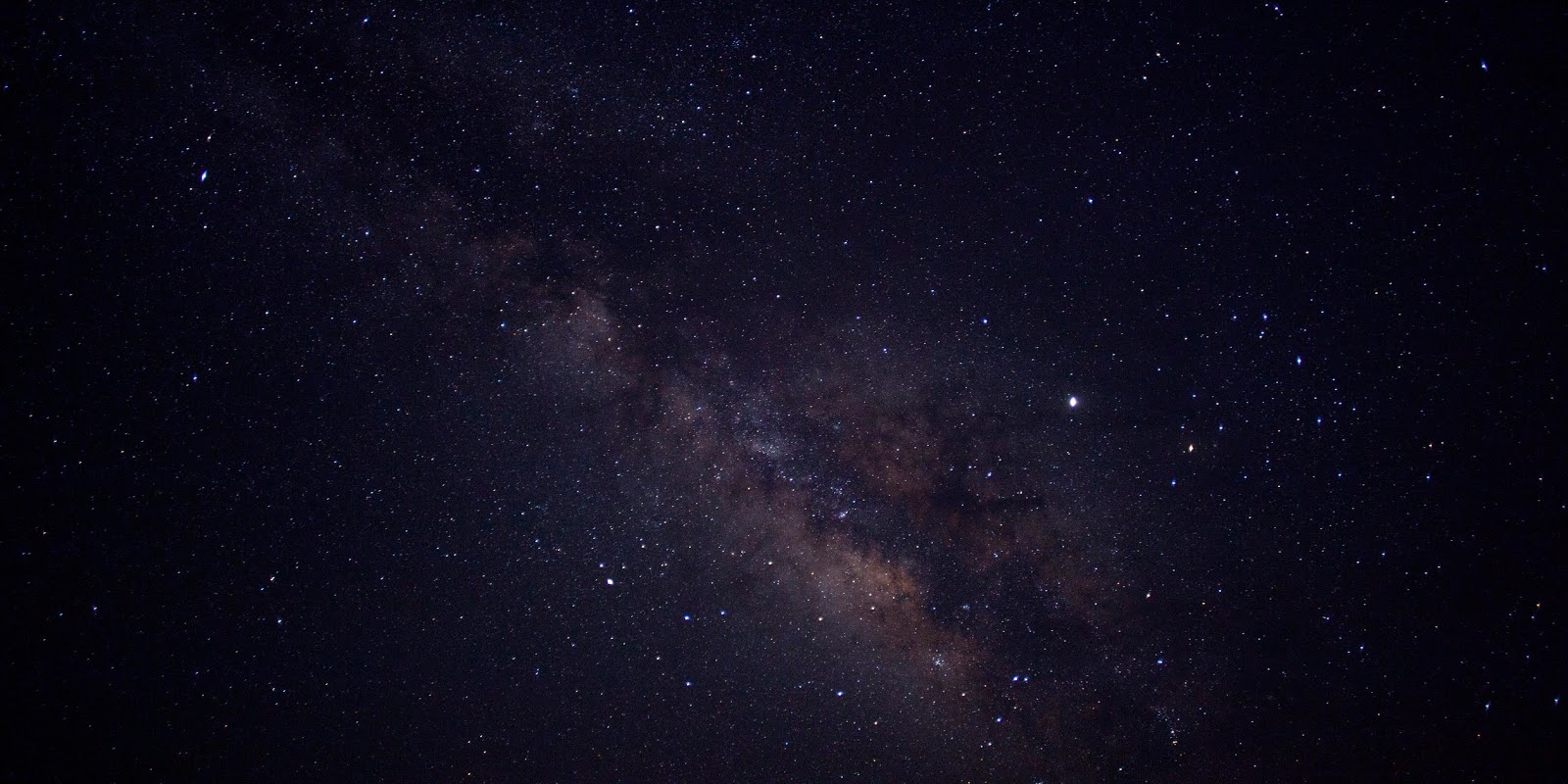
Tonopah, Nevada, which is known as a dark sky destination ...
 |
| Milky Way over Tonopah |
Mono Lake ...
 |
| Mono Lake |
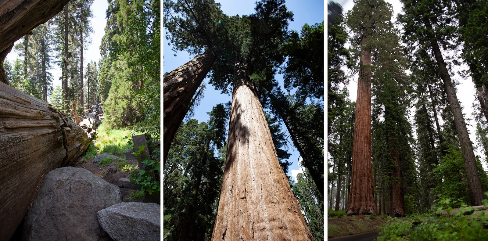
Three nights in
Yosemite at the Big Trees Lodge (AKA Wawona Lodge) because we could not get
advance camping reservations ...
 |
| Yosemite National Park |
Two nights in
Sequoia National Park, including a tour of Crystal Cave ...
 |
| Sequoia National Park |
One night in
Mill Valley so we could visit Muir Woods National Monument ...
 |
| Muir Woods National Monument |
One night at
Lassen Volcanic National Park ...
 |
| Lassen Volcanic National Park |
Three nights at
Crater Lake National Park (OK, so that one is in Oregon) …
 |
| Crater Lake National Park |
An open couple
of days to get home.
A big theme of this trip was
dark sky. Scott loves doing star and Milky Way photography and I am learning.
So, he is always looking for the darkest of the dark skies.
Great Basin National Park
That’s how we ended up
changing our plans for an evening and night in Great Basin National Park which,
as one of the lesser visited Parks, had an open campsite when we arrived.
 |
| Wheeler Peak |
Actually, there were sites at the lower campground (Baker Creek), where we
stayed, and the upper campground (Wheeler Peak), which was beautiful, but we
didn’t really want to haul the trailer up a winding road without knowing for
sure if there would be a site.
 |
| Our Campsite |
Plus, at almost 10,000 ft. in elevation, we were
concerned Wheeler Peak would be cold. Baker Creek, at 7,500 feet, was lovely.
But, we didn’t spend much time in the campsite because we went exploring, took
some Milky Way pictures, slept and left fairly early the next morning.
Great Basin
National Park, in east-central Nevada near the Utah border, was established as
a National Monument in 1922 and as a National Park in 1986. Its name references
the Great Basin, the dry and mountainous region between the Sierra Nevada and
the Wasatch Mountains that, unlike the rest of the U.S., does not drain its
waters into the Atlantic or Pacific Ocean. Rather, all water in the Basin
either evaporates or stays in the Basin.
 |
| Bristlecone Pines |
The 77,180-acre Great Basin National Park is known for ancient bristlecone pines, Lehman Caves, 13,063-foot Wheeler
Peak and Wheeler Peak Glacier.
Great Basin National Park has 11 species of
conifer trees and more than 800 species of plants; the most common are sagebrush,
saltbush, single-leaf pinyon, Utah juniper, white fir, aspen, Englemann spruce and
Ponderosa pine.
The Bristlecone Pines, possibly among the oldest living things
on Earth, grow in isolated groves just below tree line where the weather is harsh
and the growing season short. They grow very slowly, some years not even adding
a ring of growth. This slow growth makes their wood very dense and resistant to
insects, fungi, rot and erosion.
Great Basin is
also home to 61 species of mammals, 18 species of reptiles, 238 species of
birds, two species of amphibians and eight species of fish.
 |
| Common Raven |
Unfortunately, most
stayed hidden, except a little Black-Tailed Jack Rabbit that kept returning to
the same spot in the road to the campground.
 |
| Black-Tailed Jack Rabbit |
The majority of
the rocks in Great Basin National Park formed during the Cambrian when western
North America was located near the equator. Thick layers of limestone, shale
and sandstone accumulated where warm shallow seas lapped at the edge of the
continent, similar to the islands of the modern Caribbean. Then, the area went
through many episodes of mountain building, during which pressure metamorphosized
the sandstone into quartzite, shale into slate, and limestone into marble. Later,
magma extruded into overlying rock layers and cooled, forming granite.
 |
| Wheeler Peak |
The modern
basin and range topography is relatively new, forming in the last 30 million years,
during which time the crust of the Great Basin was subjected to extensive
stretching and thinning, causing the crust to break into blocks. The landscape was
later glaciated in several distinct "Ice Ages" over the last 1.5 million
years. The modern landscape of the was shaped by glaciation 40,000 to 60,000
years ago and again 14,000 to 25,000 years ago. There is only one remaining
glacier, the Lehman Cirque.
Great Basin National
Park is also home to the Lehman Cave, which formed 550 million years ago while
it was still submerged in a relatively warm, shallow ocean. This is the second
time we have been to Great Basin and the second time we did not tour the cave,
this time because the schedule just wouldn’t work.
 |
| Milky Way |
Recognized by
the International Dark Sky Association, the Park is home to
what some say are the “last true dark skies in the U.S.” Part
of the NPS’ Night Skies Program, campsites are designed
to enhance stargazing, with room for telescopes and tripods.
We went up
to an observation deck and got some great Milky Way shots.
Tonopah
Then, it was on
the Tonopah. As we left in the morning, we encountered a number of Red-Tailed
Hawks ...
 |
| Red-Tailed Hawk |
... several wind farms ...
 |
| Wind Farm |
... beautiful mountains ...
 |
| View across the valley |
 |
| Ha! |
... and some cattle signs that
reminded me of Ferdinand the Bull (this one with a hula hoop). These were certainly much spunkier than the typical cattle crossing/open range sign.
Located between Las Vegas and Reno, Tonopah is known for its night skies and actually
hosts free star parties with astronomers and telescopes every Saturday night in
the summer. It just turned out that we would be passing that way on a Saturday.
A tiny desert
mining town (population 2,500), it certainly isn’t much to look at (in fact, I
think it is uglier than Rock Springs, Wyoming). It has a few hotels (I must
say, the Best Western was pretty nice and we even went to the pool) and a really
nasty old casino where we had an OK burger for lunch. It is also home to the Clown
Motel.
 |
| Why????? Photos: Scott Stevens |
It seems like a place Stephen King might use as a setting for a book!
Tonopah was
founded around 1900 with the discovery of silver by prospector Jim Butler, who
was allegedly looking for a burro that had wandered off during the night. When
he found it the next morning, he picked up a rock to throw at it in frustration
and noticed that the rock was unusually heavy. He had stumbled upon the
second-richest silver strike in Nevada history. There are still operating mines
and a mining museum and park that we did not visit.
 |
| Tonopah; Photo: tonopahnevada.com |
 |
| Committed to astronomy |
We did go to the
star party, which is in a gravelly field on the edge of town that our GPS almost got us to (we were just over the hill in an empty field).
The town has
built a platform and added some concrete "outdoor furniture" for these parties. There were several astronomers and volunteers with telescopes and probably about a dozen attendees. It's a nice gesture for such a small town.
 |
| Tonopah Star Party |
 |
| Photo: BBC |
Although there wasn't a lot happening and there was no formal program, we did get a good look at Saturn! It looked a lot like the photo at the right. Not spectacular, but very cool that we were actually looking at Saturn. We could see rings and moons.
But, when we
tried to take Milky Way shots, we were foiled by what appeared to be a new truck
stop with incredibly bright vapor lights right down the hill.
I am shocked that
the town that promotes itself as a dark sky location doesn’t have strict
lighting rules for businesses.
 |
| Tonopah ad; Photo: tonopahnevada.com |
We had to leave the star party and drive about five
miles out of town to get anything. And, there was still light pollution.
 |
| Dark skies plus the glow of town |
Oh,
well, Tonopah was on our route, so it wasn’t a great loss. And, we did see
Saturn.
 |
| Mono lake on a beautiful day |
Mono Lake
And, then, the
next day, we traveled on to Yosemite National Park in California.
But, before you enter Yosemite from the east, you get
a treat.
Mono Lake.
An alkaline saline
soda lake near Lee Vining, California, Mono Lake formed at least 760,000 years
ago as a “terminal lake,” meaning that it has no outlet. And, having no outlet
means that high levels of salts accumulate in the lake.
Sediments located
below the ash layer hint that Mono Lake could be a remnant of a larger and
older lake that once covered a large part of Nevada and Utah, which would put
it among the oldest lakes in North America. At its height during the most
recent ice age, the lake would have been about 900 feet deep. Sitting near a
volcanic fault, the area is considered “geologically active;” the most recent
eruption occurred 350 years ago, resulting in the formation of Paoha Island.
 |
| Tufa in the lake |
The lake’s most interesting attributes are the tufa towers, columns of limestone that rise above the surface of the lake – and dot the shoreline where the formerly higher lake used to sit. Tufa is made when high concentrations of dissolved calcium ions in subsurface springs enter the bottom of the lake and cause huge amounts of calcite to precipitate around the mouths of the springs. The tufa towers originally formed at the bottom of the lake and were revealed when the lake levels fell.
 |
| Tufa |
The composition
of the towers indicates that the area was previously much colder than it is
now.
 |
| Birds approach a huge tufa tower |
The high salinity
and alkalinity of the lake keeps it free of native fish. An attempt by the
California Department of Fish and Game to stock the lake failed. The lake's food chain is based on the high population of single-celled planktonic algae that
reproduce rapidly during winter and early spring after winter runoff brings
nutrients to the surface layer of water. By March. the lake is "as green as
pea soup" with photosynthesizing algae.
The lake is famous for a tiny
species of brine shrimp, no bigger than a thumbnail, that are endemic to the
lake. During the warmer summer months, an estimated 4-6 trillion brine shrimp
inhabit the lake and feed on the algae.
Alkali Flies live
along the shores of the lake and walk underwater, encased in small air bubbles
for grazing and to lay eggs. These flies are an important source of food for
migratory and nesting birds.
 |
| Alkali Flies |
And, are there
birds!!!
 |
| Wilson's and Red-necked Phalaropes |
Mono Lake is a
vital resting and eating stop for migratory shorebirds and has been recognized
as a site of international importance by the Western Hemisphere Shorebird
Reserve Network.
Nearly 2,000,000 water birds, including 35 species of
shorebirds, use Mono Lake to rest and eat for at least part of the year. These include
American Avocets, Killdeer and Sandpipers. Over 1.5 million Eared Grebes and Phalaropes
use Mono Lake during their long migrations. While we were
there, we saw several species.
 |
| One of the most bird-full places I saw in California |
Least Sandpipers were working the shore, eating flies …
 |
| Least Sandpiper |
… as were
Brewer’s Blackbirds …
 |
| Brewer's Blackbird strutting his stuff through a cloud of Alkali Flies |
Ospreys were
nesting on tufa towers. I am not sure where they get their food because the
actual lake has no native fish; I suspect they work nearby streams.
 |
| Two different Osprey nests |
 |
| Wilson's Phalarope |
But, by far, the biggest populations were the Phalaropes: Wilson's and Red-necked.
Late every summer tens of thousands arrive from their northern nesting grounds.
Then, they gorge themselves until they continue migrating, respectively, to South America or tropical oceans.
We saw them
perched on tufa …
 |
| The tufa is great for providing perches |
Foraging along the
shore …
 |
| Wilson's Phalaropes |
Floating in the
lake …
 |
| Wilson's Phalarope |
And, flying in
huge flocks ….
 |
| Phalarope flock |
That was a real
treat ….
In addition to
migratory birds, a few species spend several months to nest at the lake. Mono
Lake has the second largest nesting population of California Gulls, second only
to the Great Salt Lake in Utah.
 |
| California Gull |
And, while we
were there, there were thousands of Swallows. There may have been a few other
varieties, but the predominant one was the beautiful (and aptly named) Violet-green
Swallow. Try as I might, I couldn’t get a good picture of one in flight, but I
did find many sitting on the tufa, resting and preening.
 |
| Violet-green Swallow |
The indigenous
people of Mono Lake are from a band of the Northern Paiute, called the
Kutzadika'a. The origin of the name "Kutzadika'a" is uncertain but
could be a Yokut Native American term for "fly eater." Indeed, the Kutzadika'a
eat the tiny Alkali Flies.
 |
| The mountains beyond Mono Lake |
The term
"Mono" is derived from "Monachi," a Yokut term for the
tribes that live on both the east and west side of the Sierra Nevada.
Mono Lake has
had an interesting conservation history. In 1941, the Los Angeles Department of
Water and Power extended the Los Angeles Aqueduct into the Mono Basin and so
much water was diverted that evaporation soon exceeded inflow and the surface
level of Mono Lake fell rapidly. By 1982, the lake was reduced to 69 percent of
its 1941 surface area. By 1990, the lake had dropped 45 vertical feet and lost
half its volume. As a result, alkaline sands and formerly submerged tufa towers
became exposed, the water salinity doubled and Negit Island became a peninsula,
exposing the nests of California gulls to predators (such as coyotes) and
forcing the gull colony to abandon this site.
 |
| Dry land as you approach Mono Lake |
Studies conducted by university students and researchers in the 1970s led to the formation of the Mono Lake Committee in 1978. It joined with Audubon to fight a now-famous court battle, National Audubon Society v. Superior Court, to protect Mono Lake through public trust laws.
While these efforts have resulted in positive
change, the surface level is still below historical levels, and exposed
shorelines are a source of significant alkaline dust during periods of high
winds.
After more than
a decade of litigation, the California State Water Resources Control Board
issued an order in 1994 to protect Mono Lake and its tributary streams. Since
that time, the lake level has steadily risen. In 1941 the surface level was at
6,417 feet above sea level. As of October 2013, Mono Lake was at 6,380.6 feet,
almost to the goal of 6,392 feet. Of course, droughts cause considerable
fluctuations.
 |
| Lake levels vary |
It was a hot
day and, after chasing Violet-Green Swallows and getting temporarily lost in the
tufa, it was time to head to Yosemite.
Trip date: July 19-August 2, 2019


No comments:
Post a Comment