 |
| Redwall Cavern |
This is the third installment of my blog about rafting with Arizona River Runners through the Grand Canyon. As I mentioned before, the blog is not completely chronological -- it somewhat follows the flow of the trip with lots of general information about typical days and typical activities. I am not making an effort to match pictures with actual places because it's just impossible to remember which is which of the 85 rapids and numerous canyons, side streams, beaches and vistas. But, the spots I identify are correct and in order.
 |
| Video grab: Scott Stevens |
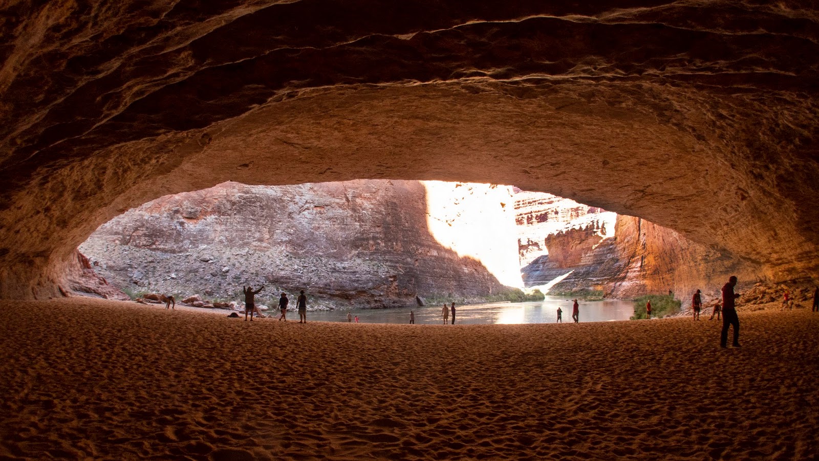
On our second day on the River, we stopped at Redwall Cavern, just a mile past our camping spot. Now, it might seem strange to travel for a long time some days and then do very short hops on other days. But, a lot depends on what campsites you can nab. You cannot go past any planned stops because you must always be moving downstream. Plus, the guides try when they can to time stops with the time of day for maximum impact.
 |
| Redwall Cavern |
Redwall Cavern is a natural amphitheater over a sand beach that was carved into the Grand Canyon's fossil-encrusted limestone walls by high river flows. Although we did see lots of beaches and some caverns on the trip, we didn't see anything else like Redwall. It is beautiful -- and huge! You can't get it all in a wide-angle lens -- fortunately a cell phone can get a panoramic shot.
 |
| Redwall Cavern |
You can see easily how the river did its work here. Redwall sits at the center point of a wide curve in the river where the walls are limestone at river level. Before the Glen Canyon Dam was built, water levels and water speed could fluctuate dramatically.
 |
| Redwall Cavern; Photo: Fellow Traveler John B. |
High water funneling through the curve would hit the limestone wall, digging deeper and deeper each time. Additional wind and water erosion has contributed to the deep, soft sand that forms the floor of the cavern, often marked with the tiny tracks of mice, bugs and lizards.
 |
| Redwall Cavern; Lower right photo: Scott Stevens |
When he first saw it, John Wesley Powell estimated that Redwall could hold up to 50,000 people. That may have been a bit of hyperbole; modern estimates are considerably smaller, but it’s still very, very big. It would certainly be a great place for a concert. But, the logistics would be impossible!
 |
| Redwall Cavern |
We explored Redwall early in the
morning, so we were in the cool shade. As we walked around, we could see the
day beginning in the Canyon around the bend. It was a very special moment.
 |
| Redwall Cavern |
Then, we were off. We passed the Bridge of Sighs, one of the
few Grand Canyon arches visible from the river.
 |
| Bridge of Sighs |
This slice of the river had numerous caves, arches and overhangs, some with interesting patterns caused by water seepage and mineral staining.
 |
| Royal Arches |
We learned that some of the red walls aren't really made of red rock. The limestone is white, but the surface is stained by seepage from a red layer above. Sometimes this creates a tiger-striping effect. In places where there have been recent rockfalls, the white is exposed.
 |
| Rockfalls expose white rock |
Rapids this morning were a bit fewer and far between.
We passed through 36 Mile Rapid (4-foot drop, rated 4) and, then, at mile 39.7,
the other site for the proposed dam that was never built. I can’t imagine, at
this point, that anyone would ever consider damming any part of this gorgeous
natural landscape. Use solar or wind for power and leave the Canyon alone.
As we traveled down the Colorado River, we passed many other rafters. There was another ARR trip, some Western River Expedition trips and perhaps a few more motorized commercial trips like ours. We also saw oar trips, including some private trips.
 |
| An oar trip in very small rafts |
There a companies that do all the logistics for private trips, including developing menus, ordering supplies, outfitting boats and stocking food. Some of these trips can take as long as a month to get through the Canyon. It's a lot tougher to take these small boats through the rapids. But, in calm water, it looks like a nice float.
Still, I was very happy with the motorized boat.
Here's a rapid we did backwards...
 |
| Petroglyph |
The Canyon makes several wide looping turns between mile 41
and mile 47. At mile 43, we passed the Anasazi Bridge, which I had trouble
seeing. This 1,000-year-old ponderosa pine footbridge
across a gap in a limestone ledge allowed Canyon inhabitants to make their way to the River from the Rim. The fact that the logs remain after all these years underscores the preservation characteristics of the dry climate.
By the way, Anasazi is a Navajo word meaning "ancient ones" or, more likely, "ancient enemies," that referred to people living in the area from approximately 200-1300.
The name was used for years to name the ancient peoples of the area and, therefore, many land formations. In recent years, however, the reference to the early people has been changed to Ancestral Puebloans, recognizing that the current Pueblo People are descended from these ancient ones.
At mile 44, we went through President Harding Rapid (4-foot drop, rated 4) that is bisected by a large rock in the middle of the river. We didn't often see big rocks in the middle.
 |
| Ancient masonry |
After a long calm float broken only by a few ripples, we passed Nankoweap Rapid.
This rapid has a huge drop – 25 feet – but a low rating – 3 – because it is spread over almost a mile.
Here there are some Ancestral Puebloean granaries that date back to 1100.
These tightly sealed masonry
structures were used to protect corn and seeds from rodents and moisture for
long periods of time. With variable weather, it was critical for the local
inhabitants to have safe food stores that could carry them through a drought or
other crop disaster.
After going through the fairly robust Kwagunt Rapid (7-foot drop, rated 5-6), we stopped for lunch.
 |
| Illustration: Grand Canyon Trust |
Then, back in the river where we passed by a site where a Phoenix developer wants to build a tramway that would bring tourists from the South Rim to the bottom.
The plan also includes a gift shop, restaurant and elevated walkway. Hmmmmm. I am thinking NO.
The Grand Canyon is a pristine environment. This project would bring more people to the
bottom in three days than normally raft through in a year.
There has been a lot of legal back-and-forth on the project. The Navajo Nation originally signed a contract to proceed, but the agreement was found to significantly disadvantage the Navajo people upon whose land the
Rim facilities would be built. The project has been halted for now but could be
resurrected. This seems like the kind of crap our current administration would support. I hope we never see a Trump Tram here.
Next, we zipped through 60 Mile Rapid (3 -foot drop, rated 4).
Had it been 60 miles already? Seemed to come quick – but then, it normally
takes about an hour to drive the same distance we just spent two days
traversing.
 |
| It's a wet, wet business |
So, here’s surprise – although we had been in Grand Canyon
National Park for over a day, we were not yet technically in the Grand Canyon;
we were still in Marble Canyon. We officially entered the Grand Canyon at mile
61.7 where the Little Colorado River feeds into the Colorado. Here we made a
stop for an adventure.
The Little Colorado River is an amazing sight. The river flows through limestone travertine, which dissolves in the water and makes it a milky brilliant turquoise. It is quite striking as it flows into the darker Colorado.
 |
| Confluence of Little Colorado and Colorado Rivers |
The tumbled rocks along the course are testament to the fact that this meandering river isn't always as gentle as it looked on the sunny, dry day we visited. When storms hit, the volume can increase, carrying rocks and lots of reddish mud into the Colorado. You can see by the olive tone to the Colorado in the shot above that this area has more sediment than some of the other parts of the river we had traveled down.
 |
| Hiking up the Little Colorado River |
We walked along a series of travertine ledges, often moving
up as high as 20 feet above the river and then back down to the river’s edge to
keep a (somewhat) level path. The Little Colorado moves swiftly with some small rapids and lots of exposed rocks.
 |
| Photo: Fellow Traveler John B |
After about a half mile, we stopped to do a quick float in the river. The technique was to take off our life jackets and put them back on like a pair of pants (or, actually, diapers).
This is designed to protect bottoms and backs from bouncing on rocks in the river. Then, those of us who wanted to got in the river and let the rapids carry us a short distance.
 |
| Scott floats the rapids -- the right way! |
This is generally the kind of thing I do not like to do, but
I am trying to work on my fear of rocks and water. After watching Scott, I went for it.
And, it all went wrong.
First, I swung too wide and started heading
for the middle-of-the-River slot rather than the preferred path (you can see Scott going through the right way in the photo montage at the left).
I tried to
correct but wasn’t strong or fast enough. This shot me further into the middle
of the river. The current there made it very difficult to get out when I
reached to spot where Scott was waiting.
I tried paddling but had to turn over
and swim. Because the water is milky,
I couldn’t see what was beneath me or how deep the river was.
I might have been
able to stand at some point, but I didn’t think to try it. Anyway, it just
wasn’t as much fun as I had hoped and it reinforced rather than alleviated my
fear of rocks and water. Darn! I was not the only one, however, to take the
wrong chute. Another traveler actually banged up his leg pretty badly when he
went through to far left.
 |
| The beautiful river is a bit scary |
Still, even with the slightly scary (and embarrassing) moment, I enjoyed the hike. The river is beautiful and the dip in the cool water made the heat of the day bearable. The water was actually a lovely temperature. After the freezing Colorado River, it actually felt warm.
 |
| Little Colorado River |
The turquoise river reminded me somewhat of the Blue Lagoon in Iceland -- the same blue water and fine silty sediment that would seriously mess up your hair. Just riding in the raft was already doing a lot of damage in that department.
 |
| Collared Lizard |
It was here that I saw this juvenile Collared Lizard. Other
members of our party encountered a much larger and more brightly colored adult
Collared Lizard. I am sorry I missed it.
From the pictures I have seen, it is confusing to determine which Collared Lizard subspecies is which because they have lots of color patterns. I originally thought Collared Lizards were an exotic animal specific to the desert. But, they are actually fairly common. They are the official state lizard (states have official lizards?) of Oklahoma!
 |
| Collared Lizard; photo: Fellow Traveler Meredith |
After our Little Colorado float, we hiked back to the rafts and shoved
off again.
 |
| Historic photo, 1956 |
We passed Crash Canyon, which holds some of the wreckage of
a 1956 mid-air collision between two planes -- a United Airlines DC-7 and a TWA Super Constellation. The collision occurred when both
pilots veered off course to give passengers a look at the Canyon.
The TWA plane
is in Crash canyon; the United plane is about a mile upstream.
All 128 people on both flights died, making it the first commercial airline crash to result in
more than 100 deaths.
At the time, the airspace was uncontrolled and pilots were responsible for maintaining separation ("see and be
seen"). The collision resulted in a significant overhaul of aviation
safety standards.
We passed through six more rapids before stopping for the
evening: Lava Canyon (Chuar) Rapid (4-foot drop, rated 3-4), Tanner Rapid (20-foot
drop, rated 4), Basalt Rapid (rated 2), Unkar Rapid (25-foot drop, rated 6-7),
Escalante Rapid (rated 3) and Nevills Rapid (16-foot drop, rated 6-7).
The video below, shot by Scott, demonstrates how much the rafts bounce in the rapids.
The Tanner Rapid is the terminus of the Tanner Trail. This is the first of a few places that we saw hikers along the river. They looked a lot hotter than we were.
We camped that night at Upper
Nevills at mile 76. Here, we really couldn’t find a decent place to set up
camp and some very nice fellow travelers consolidated with the rest of their
family to give us a lovely secluded spot surrounded by tree. We did have to
duck under a low (like 4 and half feet above the ground) branch on the path to
the tent, but I managed to not whack myself on it.
 |
| Campsite conversation |
Once again, the guides offered
to lead a hike. We grilled the guides about hike expectations to see if there
was scrambling – which I hate – and severe heights – which another guest hates.
Since there was some of both, I opted not to take the hike. Rather, I stayed
behind to set up camp, chill and take pictures. The hikes had one exciting
moment when a Desert Bighorn Ram almost plowed the hikers down. It ran straight
down the trail right past them before settling on a ledge above.
Our campsite sat just above Hance Rapid (30-foot drop, rated
8-9), one of the biggies on this trip. We could see and hear it roiling all
night long.
 |
| Hance Rapid; photo: Scott Stevens |
This night, I decided to take the plunge (almost literally) and do some washing up. This involved
gathering shampoo and soap (biodegradable) and wading into waist-deep icy cold
water. I used a cup to help rinse my hair so that I never had to actually
submerse myself. It is truly the first time I ever got a brain freeze from
washing my hair. It was not, however,
nearly as bad as I expected. I managed to wash my hair three times on the trip.
 |
| Vishnu Schist meets cold, clean water |
I wish that I had brought some spray-in conditioner. The
combination of biodegradable shampoo and cold water made combing impossible. I
think I pulled out half my hair. I had taken my quick-dry REI travel towel (the
one Caty bought me for Africa, but I never used because it spent the whole
Africa trip lost with her luggage). It worked very well. It dried my hair and
then quickly dried itself. It folds up tiny and is a great tool for this kind
of trip.
It was while washing my hair that my feet got mired in the
soft mud on the river bottom. As I tried to pull my foot out, the thong broke.
Ooops. I missed those shoes for the rest of the trip.
 |
| Photo: Scott Stevens |
Because we were in the desert, my hair dried quickly – and not particularly fashionably. It was completely dry by bedtime. I slept well (and clean).
So, Day 3 began, literally, with a splash as we navigated Hance Rapids.
Hance has large rocks that constrict the channel to form powerful hydraulics.
This is one of the rapids that the drivers talked about as tricky – and fun.
As we pulled out, we entered the
beginning of Upper Granite Gorge, the first of the three major Grand Canyon gorges. Our route passed through two of them. The three-day motorized trip goes through the other one. Upper Granite Gorge is the first place where the exceptionally hard (and,
thus, steep) pink Zoroaster Granite and black Vishnu Schist appear.
As Brie
said, it was our first “schisty” area. Most of the difficult rapids in the
Grand Canyon can be found within these steep, unyielding canyon walls our route took us through.
 |
| On the river |
Hance is followed by another fun one -- Sockdolager (slang
for knockout blow) Rapid (19-foot drop, rated 7-9).
 |
| A real knock-out |
Around this time, we saw the first man-made structure since
Navajo Bridges. Desert View Watchtower stands on the edge of the South Rim. Designed
by Mary Elizabeth Jane Colter, who is often referred to as the architect of the
southwest, the tower is patterned after Ancestral Puebloan buildings at
Hovenweep and the Round Tower of Mesa Verde. We could just see this distinctive
circular tower as we floated past.
 |
| Desert View Watchtower from the top |
Next came, a relatively quick succession of significant
rapids -- Grapevine Rapid (17-foot drop, rated 6-8), 83 Mile Rapid (7-foot
drop, rated 3-6), Zoroaster Rapid (5-foot drop, rated 5-7) and 85 Mile Rapid (rated
3-5) – before we reached the Kaibab Bridge and Phantom Ranch boat beach, where
the South Kaibab Trail crosses the river. This marked the intersection with a
place I had actually been before.
 |
| Me at the Bright Angel Suspension Bridge in 2005 |
Located on the north side of the Colorado River at the confluence with Bright Angel Creek and Phantom Creek, Phantom Ranch is a stopping point for mule trips, backpackers and hikers. It has bunkhouses, cabins, a canteen with a bar, a campground, a mule corral, emergency medical facilities, a ranger station and a heliport. Built in 1922, it is a member of Historic Hotels of America, the official program of the National Trust for Historic Preservation. Native American pit houses and a ceremonial kiva dating from about 1050 have been found on the site.
 |
| Phantom Ranch, 2005 |
The earliest recorded non-Native American visitor was John Wesley Powell and his party in 1869, when they camped on the beach. Prospectors worked the area in the 1890s, creating mule trails to haul ore. In the early 20th century, the Grand Canyon Transportation Company improved the trail from Phantom Ranch to the North Rim to attract tourists. President Theodore Roosevelt traveled down the Canyon to the camp during a hunting expedition in 1913; in honor of this visit, the site became known as Roosevelt Camp.
 |
| Powell, Roosevelt, Grand Canyon prospector, Harvey, Colter |
After the Grand Canyon became a National Park, the Fred Harvey Company was granted the concession for the camp in 1922. Mary Colter designed the permanent lodging and suggested that its name be changed to Phantom Ranch. During the Depression, the Civilian Conservation Corps made improvements to the Ranch and its trails.
As the Grand Canyon's popularity grew, the National Park Service instituted a permit system for overnight stays at the ranch. Starting next year, reservations will be granted via a lottery system.
The only modes of access to the Ranch are foot trails (also used by mules) and the Colorado River. The North Kaibab Trail leads 14 miles to the North Rim. The 9.3-mile route to the South Rim follows the River Trail for two miles and then climbs the Bright Angel Trail to Grand Canyon Village. The 6.3-mile Kaibab Trail is generally used only for descent into the canyon; it is quite steep for ascent.
 |
| Kaibab Suspension Bridge, 2005 |
The two trail bridges near the ranch – the Kaibab Suspension Bridge built in 1922 and Bright Angel Suspension Bridge built in 1970 -- are the only Colorado River crossings within the Canyon.
 |
| Approaching the Kaibab Suspension Bridge; Photo: Scott Stevens |
It was an exciting new
perspective to pass under them.
 |
| Selfie under the Kaibab Suspension Bridge |
Bright Angel Rapid (rated 3) sits between the two bridges.
And, then we were pulling away from civilization again, passing through Pipe Springs
Rapid (7-foot drop, rated 4) and Horn Creek Rapid (9-foot drop, rated 8-9), Salt
Creek Rapid (5-foot drop, rated 3), Granite Rapid (18-foot drop, rated 8-9 and
one of the more difficult rapids with a strong push of hydraulics to the wall
on river right), Hermit Rapid (15-foot drop, rated 8-9 with perhaps the
strongest hydraulics and biggest waves in the canyon) and Boucher Rapid (13-foot
drop, rated 4-5).
Here's another video Scott shot.
Next came Crystal Rapid (17-foot drop, rated 10), which –
based on their comments – I believe is the most challenging rapid for the
drivers. Formed in 1966 when a flash flood in Crystal Canyon washed debris into
the River, Crystal Rapid features several very large holes followed by a
dangerous rock garden at bottom of rapids on river left.
Next were Tuna Creek Rapid (10-foot drop,
rated 5-7), Lower Tuna (Willie's Necktie) Rapid (10-foot drop, rated 4) and
Nixon Rock (rated 4) before the beginning of a series of rapids called
"the gems," that includes Agate Rapid (rated 3), Sapphire Rapid (8-foot
drop, rated 6), Turquoise Rapid (4-foot drop, rated 3-5), 104 Mile (Emerald)
Rapid (4-foot drop, rated 5) and Ruby Rapid (11-foot drop, rated 5-6). The run
from Crystal to Ruby spans almost seven miles.
 |
| Roiling water |
After one more run -- Serpentine Rapid (12-foot drop, rated 6-7),
we stopped – wet and exhilarated – for lunch at the Ross Wheeler campsite, where there is an abandoned boat from an expedition 100 years ago! We
were 108 miles in – more than half way.
 |
| A stop for the night |
Trip date (rafting): May 15-20, 2018


No comments:
Post a Comment