 |
| A Northern Giant-Petrel in the Drake Passage |
Why?
Named after 16th-century English explorer and privateer Sir Francis Drake, the Drake Passage connects the southwestern part of the Atlantic Ocean (Scotia Sea) with the southeastern part of the Pacific Ocean and extends into the Southern Ocean. By the way, Drake never sailed it!
Because currents can circumnavigate the Earth without meeting any landmass resistance, waves can build and build, often topping 40 feet.
 |
| Left: Dreamstime; Right: X.com |
The Drake Passage has the reputation for being "the most powerful convergence of seas.”
 |
| It can be rough; Photo: Quark Expeditions |
This unimpeded path around Antarctica also has allowed the Drake Passage to strongly influence global oceanic circulation, as well as the global climate.
When the Drake Passage opened between Antarctica and South America around 30 million years ago, the effect on global oceans was massive. As ocean currents encircled Antarctica, the continent was cut off from receiving heat from warmer regions. This changed global climate and probably caused the rapid expansion of Antarctic ice sheets.
 |
| Ship plowing through; Photo: 7Toucans |
Despite its roughness, the Drake Passage is still the best route to Antarctica because it is only about 500 miles across.
Traversing open ocean, it has very little to navigate around and it is very, very deep, averaging about 11,000 feet.
It is also the preferred route between the Atlantic and Pacific around South America. The other two passages – the Strait of Magellan and the Beagle Channel – have frequent narrows, leaving little maneuvering room for a ship, as well as unpredictable winds and tidal currents.
Drake Passage has two states: the “Drake Lake” or the “Drake Shake.” The latter features the up-to-40-foot waves I mentioned. People I have met who crossed it have had to strap themselves into their beds to prevent being thrown out while sleeping. Others told me that their cruise suggested they skip the bed and sleep on the floor.
 Our ship provided bolsters to slip under the mattress on either side to create a cup shape to hold us in bed.
Although I have never been truly seasick, I have a tendency towards queasiness and I was dreading this.
I got a prescription for Scopolamine patches for both crossings (I have used them before to prevent nausea from anesthesia).
Fortunately, we had what was termed “Drake Lake.” No, it wasn’t glassy smooth; there were pretty significant swells that required holding on to anything in sight to walk about and that tossed some water bottles off our desk in our cabin. But, according to the trip’s guides, we had about a “2 out of 10.” A big relief and a bit of trepidation about what a 10 would be.
 |
| I don't know how to read these, but they're good news; Source: G Expedition Trip Log |
Regardless, I was fine. No queasiness. Scott also put on a patch, but he wasn’t feeling well at all (more on that later).
I was even able to go out on deck to look for birds. It was a bit windy, but that’s good for watching the big seabirds that like to ride the wind.
 |
| A Black-browed Albatross enjoying the breeze |
In general, the journey takes approximately 36 hours from Ushuaia, much at night so as not to waste valuable touring time. Well, actually, the schedule is based on de-boarding a returning ship in Ushuaia in the morning, then cleaning, refueling and restocking in time to board the next tour in the afternoon.
As we traveled south, we started to see some rather large icebergs.
 |
| We were getting excited |
Because the passing was “calm,” we made good time and were able to make a stop that we would have had to skip had the trip through Drake Passage taken longer.
Scott captured part of the crossing here.
Deception Island
Located within the Bransfield Strait in the south Shetland Islands just above the tip of the Antarctic Peninsula, Deception Island is the submerged caldera of an active volcano with a collapsed wall on one side that has allowed seawater to fill the caldera and provides a path in for boats.
 |
| Zooming in on Deception Island; Maps: Google Maps |
How active is the volcano? Once we got into the caldera, we could see steam rising from the ground and I read that sometimes tourists create warm baths by digging into the sands of the beach. The volcano erupted in 1839-1842, 1967, 1969 and 1970, the most recent times damaging scientific stations. The history of volcanic eruptions is still under investigation, but several additional larger eruptions are known to have occurred in the past 10,000 years.
 |
| This cinder beach is evidence of recent activity |
Roughly circular, Deception Island has a maximum diameter of about 9.3 miles. The highest peak, Mount Pond on the east side of the island, has an elevation of 1,768 feet, while Mount Kirkwood on the west has an elevation of 1,483 feet. Over half of the island is covered by glaciers up to 32 feet thick, ice-cored moraines and ice-covered pyroclasts (cinders, ash and volcanic “bombs” formed when clumps of lava blasted out of the volcano harden and form rounded stones).
 |
| Glacier and iceberg |
The bay in the center, called Port Foster, is 6.2 miles long, 4.3 miles wide and up to 560 feet deep. The bay’s entrance, called Neptune's Bellows, is just 1,640 feet wide.
 |
| Looking into Neptune's Bellows |
The port is rimmed by a shallow coastal shelf with volcanic cinder beaches, which is where our Zodiacs landed.
 |
| Landing on the circular beach |
The outer coast of the island is characterized rocky and icy cliffs.
 |
| Outside the caldera |
After a day and a half without seeing much land, it was exciting to finally have a view of Antarctica (or, technically, “Almost Antarctica”).
As we approached the island, I saw a number of birds, including ...
 |
| Blue-eyed Shags |
 |
| Southern Fulmars and Northern Giant-Petrels |
 |
| A Wilson's Storm Petrel and lots of Cape Petrels, also called "Pintado" or “Painted” Petrels |
As I stood on the deck looking at the birds and scenery, something caught my eye.
 |
| What was it? |
Penguins! The water was full of Chinstrap Penguins swimming in their unique leaping-out-of-the-water style.
 |
| I knew they did this, but I didn't realize how often |
Tricky to photograph, but great fun to watch.
 |
| WOW!!!! |
Then we entered the bay through Neptune's Bellow's. You can watch Scott's video of the entry here.
Once we were in, we could see a large number of Chinstraps on the opposite shore, hanging around on the beach. And, if you looked closely, you could see a path (paved with Penguin poop) that led to a spot very high on the mountain where they nested.
 |
| You can see Chinstraps on the beach and climbing up the cliff |
Just inside Neptune's Bellows bordered by a black sand beach lies Whalers Bay.
 |
| Looking back at Neptune's Bellows |
The G Expedition dropped anchor and then we boarded Zodiacs ...
 |
| Our group was first off, so we could watch others board the boats |
... and we were ferried across the bay to the shore to explore the funky little island.
 |
| The Zodiacs are a great way to travel |
The first thing we saw was three Chinstrap Penguins just down the beach ...
 |
| Our first close-up of Penguins |
Because adults have no significant terrestrial predator, they do not fear people and we were able to get quite close ...
 |
| They even approached us |
They contemplated the surf …
 |
| Should we? |
... and then dove into the water …
 |
| Sure, what the heck? |
Much of the group hiked to the top of a cinder hill for a higher-up view of the harbor.
 |
| We heard the hike was tougher than it looked because the ciders were loose |
We opted to photograph the Chinstraps and then explore the ruins of an old Whaling community and the British Antarctic Survey base that was evacuated during the 1967 eruption.
Deception Island was first visited and explored by the American Sealer Nathaniel Palmer (after whom the U.S. originally named the Antarctic Peninsula) in 1820. Palmer named it "Deception Island" because the outward appearance looks like a normal island until you find Neptune’s Bellows and discover its bay.
 |
| Palmer's ship |
But back to icky parts of history: Over the next few years, Deception Island became a focal point of the short-lived Fur-Sealing industry in the South Shetlands. The island itself didn't have a large Fur Seal population, but it was a perfect rendezvous point because the natural harbor remains mostly free from ice and winds.
 |
| The harbor |
Massive overhunting almost eradicated Fur Seals in the South Shetlands within a few years and the Sealing industry collapsed as quickly as it had begun.
The second phase of human activity began in 1904, when an almost untouched population of Whales attracted Whalers to the South Georgia and South Shetland Islands.
 |
| We saw so, so many Humpback Whales on this trip |
A lack of shore-based infrastructure meant that the Whales had to be towed to moored factory ships for processing. The ships needed a sheltered anchorage and a plentiful supply of fresh water, both of which could be found at Deception.
 |
| Harbored ships; Photo The Whaling museum (Norway) |
In 1908, Britain formally declared the island to be part of the Falkland Islands under British control. They appointed a magistrate and customs officer to ensure that Whaling companies followed catch quotas and paid license fees. A post office and cemetery were built in 1908, a radio station and hand-operated railway in 1912 and a small permanent magistrate's house in 1914. The cemetery, by far the largest in Antarctica, held graves for 35 men along with a memorial to 10 more presumed drowned.
 |
| Old graves |
Factory ships of the period were able to strip the blubber from Whales, but could not use the carcasses. Up to an estimated 4 percent of the available oil was wasted. Then, a permanent on-shore station established by a Norwegian company in 1912 became the only successful shore-based industry ever to operate in Antarctica, reaping high profits in its first years.
 |
| Processing Whales on Deception Island; Photo: Wilkins Collection, Byrd Center/Ohio State |
Then, in the 1920s, newer factory ships fitted with slipways could tow aboard entire Whales for processing and Whaling companies were no longer tied to sheltered anchorages. These pelagic Whaling companies could ignore quotas and escape the costs of licenses, which rapidly led to overproduction of oil and a collapse in the market. The less profitable and more heavily regulated shore-based companies couldn’t compete and the Whaling base at Deception Island shut down in 1931.
Deception Island remained uninhabited for a decade, but was revisited in 1941 by a British warship that destroyed the oil tanks and some remaining supplies to ensure it could not be used as a German supply base during World War II.
 |
| Old boilers and fuel tanks; Lower right photo: Scott Stevens |
In 1942, an Argentinean ship visited and left signs and painted flags declaring the site Argentinean territory; the following year, a British party returned to remove the signs.
The British protected the harbor during the war to keep it from being taken by Japan and to protect their claim to it and the Falklands.
After the war, it was used for scientific research. The British base, Station B, conducted meteorological and geological research and was a center for aircraft operations in 1955-57 and 1959-69. After the volcanic eruptions destroyed the stations, the island remained vacant for several years before researchers returned.
 |
| The hangar is rusting away |
There used to be an old airplane fuselage, but it is being restored and may be returned to the island.
Deception Island exhibits some wildly varying microclimates. Near volcanic areas, the air can be as hot as 104°F and water temperature can reach 158°F. For this reason, Deception Island has the greatest number of rare plant species of any place in the Antarctic. They must be hiding because we didn't see much in the way of plants.
 |
| The glacier on the smoking mountain |
Scott and I looked at and photographed the decaying ruins. I came upon some Kelp Gulls and their chicks on the top of rusting tanks.
 |
| Nesting in the ruins |
As we walked along the beach, I went to investigate some more Penguins and discovered they were a different species, called Gentoos. Later on in the trip, we saw hundreds (probably thousands) of them. In my next post, I will talk exclusively about the Penguins we saw during our trip.
 |
| Gentoo Penguins, even more chill than the Chinstraps |
Deception Island was interesting and the facing mountains were lovely, but it wasn’t what I expected in Antarctic. That was to come.
 |
| I was looking forward to icebergs and Penguins, not expecting old buildings |
We were lucky, however, to even see it. Had the Drake Passage been rough (and, thus, slower), we would have had to sail right by.
About Zodiacs
This excursion was via Zodiac, as were all of our excursions.
 |
| Zodiacs leaving the G Expedition; Photo: Scott Stevens |
 |
| Exploring |
Zodiac inflatable boats are commonly used by the U.S. Military, but were brought into civilian use in the late 1960s. They are made with an inflatable buoyancy tube and have a semi-rigid hull made of a very strong PVC-based material. They use an outboard motor.
Zodiacs combine the advantages of inflatable boats – security, stability, portability and ease of use – with those of rigid-hulled boats – comfort, agility and speed. The buoyancy is distributed on the sides, the center of gravity is very low: this makes it much harder to capsize the vessel.
 |
| Steady as we go |
I mentioned that G Adventures is a Canadian company. They have named all their Zodiacs after Canadian provinces and territories.
 |
| Labrador and Newfoundland stacked on the desk |
Plus, one was named after a former G Adventures Zodiac Master, who was, apparently legendary.
Zodiacs are a mainstay of Arctic and Antarctic cruises because they are easy to deploy, fast and agile, they can travel in shallow water and they can land on rocky or sandy beaches.
 |
| Landings; Left photo: Ship Photographer Sheeren Mroueh |
The Expedition leaders each take 8-12 passengers and drive them aboard the Zodiac for both shore landings and cruising around the frigid bays. They usually stand when they drive.
 |
| Sarah at the helm |
The only downside I could see to Zodiacs was that, when full, it can be tough to get a photo because people get in your way.
 |
| This problem got solved (in a weird way), you'll read about it in a later post |
We disembarked and embarked from the ship to the Zodiacs via a mudroom, where we each had an area with a bench and hooks to store our Expedition-provided and incredibly comfy gumboots (unlike the jacket, loaners not keepers) and lifejackets (fortunately, a very slim, non-bulky style – you would most likely freeze before you drowned anyway) plus our personal rain pants, jackets or whatever else we didn't want to schlep back and forth to our cabins.
On the first day onboard the ship, we signed up for a "group," which was used to determine our departure. We called by group to keep the mudroom from getting too crowded.
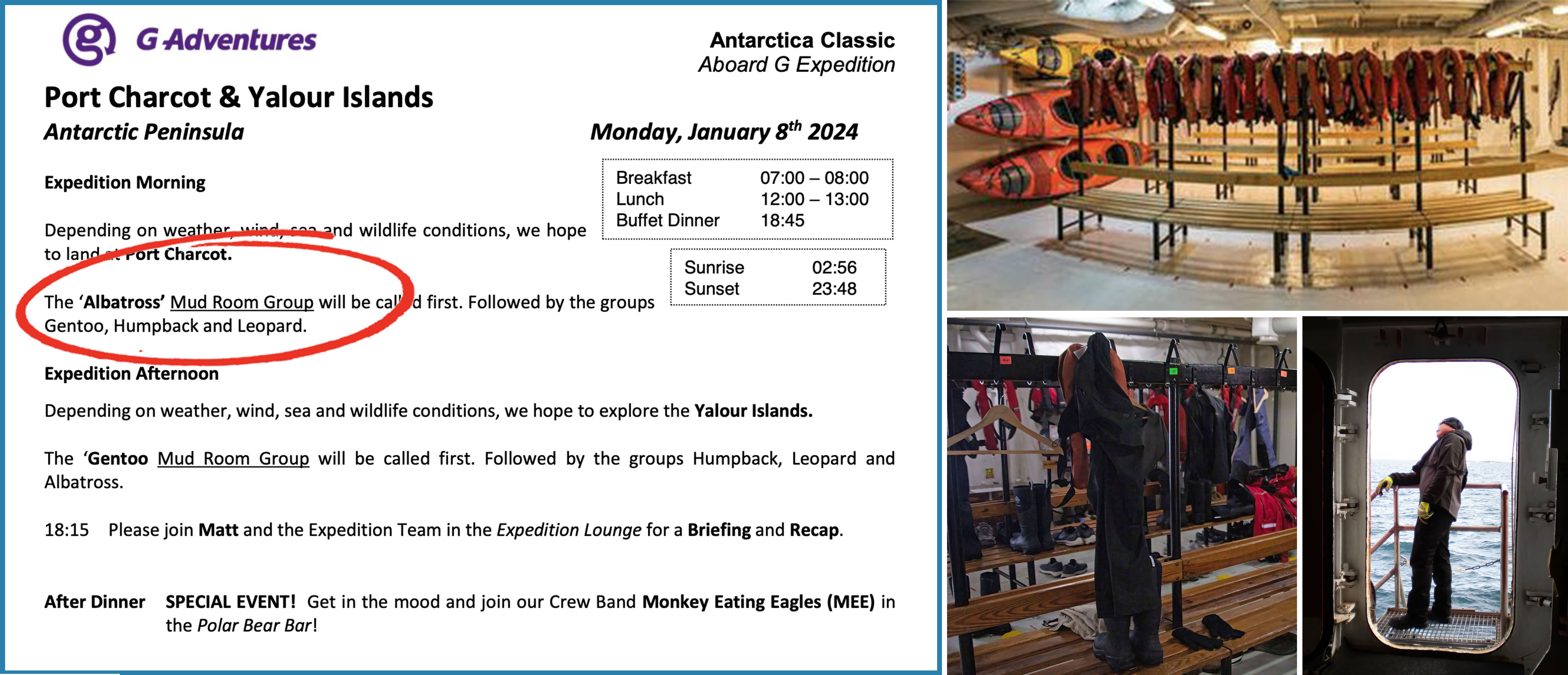 |
| The mudroom was a portal to excitement; Upper right photo; G Adventures |
Once there, we donned our waterproof pants (outside the boot, not inside or you might get a shoe full of water!), Expedition jacket, and life vest.
 |
| This ensures you aren't left behind |
Once in the boat, you sit and slide to your position as directed by the driver.
 |
| Exploring; Photo: Scott Stevens |
In really rough seas, getting on and off these boats could be tricky, but I never had an issue.
Watch Scott's video of the G Expedition crew bringing their Zodiac back in.
On different days, I used different cameras, usually taking one with a long lens for wildlife and one with a wider-angle for scenery. On snowy/foggy/wet days, I took a bag or wrapped the camera.
 |
| Shooting from the Zodiac; Photo: Scott Stevens |
Even though carrying heavy cameras can put me a bit off balance, I always felt secure in the Zodiac. And, except for our choppiest day, I always stayed dry (I took my waterproof camera bag that day).
 |
| Approaching the ship |
Some excursions had both shore and cruising activities and some were just water-based.
The first formal activity (remember, Deception Island was an add-on) included a snowy/icy hike (I will cover in an upcoming post).
I think a number of people decided that hiking wasn't for them and asked for accommodation. So, thereafter on days with landings, G Adventures also offered cruise-only boats, which left after the assigned groups.
When an activity was done, we returned to the ship, tied up and reversed the process: sliding along the seat as directed, being helped out of the boat, climbing up the stairs, swiping the ID and walking through the disinfectant.
 |
| Returning to the ship (those in green and orange are crew members) |
Then, as an additional environmental precaution, we were asked to inspect and, if necessary, scrub our boots to remove dirt, plant material or rocks.
After the last group had cleared out of the mudroom, the crew inspected the boots. If boots needed more work or someone forgot to swipe back in, they called them back to the mudroom. Fortunately, I was never called to do the walk of shame.
Zodiac touring is awesome. You are right in the middle of everything.
 |
| Skirting a glacier |
We were able to weave around icebergs that a ship could never get near.
 |
| Getting close to icebergs |
On one occasion, we had a very close Humpback Whale encounter. Often, we cruised close to Seals, Terns and Shags and, several times, Penguins swam right by us.
 |
| Zodiac sightings |
So cool.
And, speaking of Penguins, that is what I will cover in my next post.
Trip date: December 30, 2023 - January 12, 2024
No comments:
Post a Comment