 |
| Kīlauea lava |
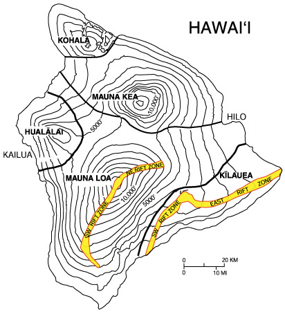 |
| Map: UH Hilo |
The five that make up the island, from oldest to youngest, are:
Kohala – extinct
Mauna Kea – dormant
Hualālai – active
Mauna Loa – active
Kīlauea – active
The other two volcanoes are submarine: Māhukona off the northwest corner of the island and Kamaʻehuakanaloa (formerly Lōʻihi) 22 miles southeast. The latter is an erupting seamount that now reaches approximately 3,200 feet below the surface of the ocean and will likely break the surface of the ocean sometime between 10,000 and 100,000 years from now.
 |
| Kamaʻehuakanaloa from a sub; Photo: Nautilus Live |
Mauna Loa is partially within and Kīlauea is totally within Hawai’i Volcanoes National Park.
Because Mauna Loa and Kīlauea are active, the island of Hawai’i is still growing.
 |
| Cooled lava at the ocean's edge |
Between January 1983 and July 2018, lava flows added 1,418 acres to the island. Lava flowing from Kīlauea has destroyed several towns, including Kapoho in 1960 and again in 2018, and Kalapana and Kaimū in 1990.
 |
| Homes burning on 2018; Photo: ABC News |
Of course, volcanoes mean seismic activity. The most destructive earthquake in the island’s recorded history was in 1868 and measured between 7.25 and 7.9 in magnitude. It triggered a landslide on Mauna Loa and killed 31 people. A tsunami claimed 46 more lives and five villages were severely damaged. The tsunami reportedly rolled over the tops of the coconut trees up to 60 feet high and reached a quarter of a mile inland in some places. In 2018, when Kīlauea erupted after multiple small earthquakes, a 6.9 magnitude earthquake occurred the next day.
 |
| 2018 activity; Chart: Pacific Tsunami Warning Center |
While lava builds the island, parts are also slipping away, often because of seismic activity.
 |
| Before and after, 1975; Photos: UH |
In 1975, a 37-mile-wide section of the Slump dropped 11.5 feet and slid 26 feet toward the ocean, causing a 7.2 magnitude earthquake and a 48-foot-high tsunami.
Undersea measurements show that a "bench" has formed a buttress that may reduce the odds of future catastrophic detachment.
Not satisfied with its own destruction, the island suffered tsunami damage from earthquakes in Alaska in 1946, in Chile in 1960 and in Japan in 2011.
Vog (volcanic fog), which contains harmful acidic chemicals, can envelop Hawai’i when there is an eruption.
Because we truly wanted to see some volcanic activity (after failing in Iceland), we planned to visit Hawai’i Volcanoes National Park and booked a helicopter tour out of Hilo. Back in 1999, we took a helicopter trip and saw rivulets of lava flowing into the ocean.
 |
| An old shot of island formation from 1999 |
A Quick Stop
So we set out in the morning for Hawai’i Volcanoes National Park (HVNP). We started out by retracing our route from the previous day, stopping first at beautiful Manukā State Wayside, which was humming with birds. There was a huge flock of Saffron Finches in the trees …
 |
| Juvenile Saffron Finch |
… and on the ground …
 |
| Adult Saffron Finch |
There was also a smaller flock of Java Sparrows …
 |
| A very pretty bird |
... a Warbling White-eye ...
 |
| They tend to be solitary, not in large flocks |
... and even some Common Waxbills …
 |
| Still camera shy |
There was a trail, but we were anxious to get to the National Park, so our stop was brief.
 |
| We didn't take advantage of everything this lovely Park had to offer |
Ka Lae
Even though we were anxious to see volcanoes, we were making good time and we couldn't resist pulling off the main highway to visit the southernmost spot in the United States: Ka Lae.
 |
| On the way to the end of the world |
We didn't know where we were going, so we just followed the narrow road that traversed flat grassy fields that were being buffeted wildly by ever-increasing wind gusts.
 |
| A Pacific Golden-Plover hunkering down in the blowing grass |
Also known as the South Point Complex, this area is thought to be the site of one of the earliest settlements in the Hawai’ian Islands and is believed to be the landing place of Hawaii's first inhabitants.
 |
The remains of a house, a fire hearth and more than 14,000 artifacts were found at the site, including coral and stone abraders (files used to make fish hooks) and over 60 different types of large fish hooks. Several from the Bishop Museum shown at left.
The site appears to have been used continuously for fishing and as a settlement over a period of more than a thousand years.
As we drove, we passed a turn-off and ended up a somewhat sketchy spot where the road dead-ended into a parking area. We got the feeling that this was an area frequented by Hawai’ians who dislike tourists, so we high-tailed it out and went back to the exit, which is where we should have turned to get to Ka Lae.
 |
| This was not the place |
We stopped along the way to admire a pretty cove and then headed to the end of the road.
 |
| Breathtaking |
South Point is a flat, windy plateau situated on high cliffs above the ocean.
 |
| A wide view; Photo: Scott Stevens |
The waters off the point are very deep and dangerous with strong currents and are well known for their abundance of large fish such as ahi (yellow tuna), mahimahi and marlin. Because it's difficult to fish from boats off South Point, the ancient Hawai’ians, who fished from canoes, drilled mooring holes through rock ledges on the plateau.
 |
| With such strong winds, I was afraid to go close to the edge |
Fishermen would pass strong ropes through the mooring holes, tie them off and then tie the loose ends to their canoes. This would allow the currents to carry the canoes into deep-water fishing grounds without being swept out to sea.
 |
| Warning! Yep, those are fish tails! |
There are also numerous salt pans that ancient Hawai’ians carved into the lava rock and filled with ocean saltwater. When the water evaporated, the remaining salt was used to preserve fish.
The best evidence of South Point's historical value as a fishing spot is Kalalea Heiau, an ancient fishing shrine (ko'a) to Ku'ula, the god of fishing. The heiau has stone walls that form a nearly perfect square of approximately 42 feet by 38 feet. Just outside the west wall is a 20 by 20-foot platform paved with stones, which served as a place to prepare fish for meals or sacrifices. Local fishermen still visit Kalalea Heiau to leave offerings in the hopes of finding good fishing off of South Point or as thanks for a successful catch.
 |
| The spot is sacred to natives |
When we arrived, I walked to the end against a wind so strong that I had difficulty making progress. I was sand-blasted along the way. But, it was worth it to see the roiling surf and pretty blue water.
 |
| Dramatic |
Hawaiʻi Volcanoes National Park
Hawai’i National Park, which was originally established in 1916, was split into Hawai’i Volcanoes National Park (HVNP) and Haleakalā National Park on Maui in 1961.
 |
| A must-see National Park |
Its purpose is to protect, study and provide access to Kīlauea and Mauna Loa and to perpetuate endemic Hawai'ian ecosystems and the traditional Hawai’ian culture connected to these landscapes. It was designated as an International Biosphere Reserve in 1980 and a World Heritage Site in 1987. HVNP has trails, rock walls and archaeological sites from as old as the 12th century.
The Park protects 505 square miles of land, including diverse environments from sea level to the summit of Mauna Loa at 13,679 feet. Climates range from lush tropical rainforests to the arid and barren Kaʻū Desert.
 |
| A bird's nest in the Park |
Eruptive sites include the main calderas of Kīlauea, a more active but remote Kīlauea vent called Puʻu ʻŌʻō and Mauna Loa’s caldera.
 |
| Kīlauea caldera |
The main entrance to the Park is on the Hawaii Belt Road. The Chain of Craters Road leads to the coast, passing several craters from historic eruptions. The road had continued to another Park entrance near the town of Kalapana, but that portion is covered by a lava flow and is only available as an emergency evacuation route.
 |
| Multiple places to see |
Kīlauea and its Halemaʻumaʻu caldera were traditionally considered the sacred home of the volcano goddess Pele and Hawai’ians visited the crater to offer gifts to the goddess.
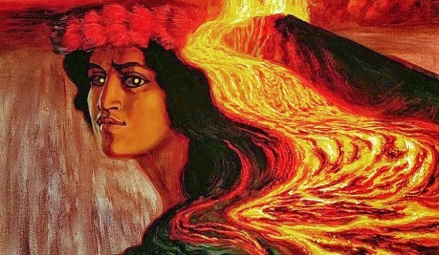 |
| Pele by Herb Kawainui Kāne |
 |
| Footprints; Photo: Only in Hawai'i |
The volcano became a tourist attraction in the 1840s, and with a series of hotels at the rim. Volcano House (I wish we could have gotten reservations there) is now the only hotel or restaurant located within the borders of the Park. Hotel owners proposed the idea for the Park in 1903.
 |
| Congressional visit to Kīlauea |
 |
| A typical occurrence at HVNP |
In 2003, the Park was enlarged by 56 percent with acquisition of 181 square miles of the Kahuku Ranch, the largest land purchase in Hawai’i's history.
HVNP expanded again this year when The Trust for Public Land transferred ownership of 25-square-mile Pōhue Bay and surrounding land. Pōhue Bay is home to numerous well-preserved and significant Hawaiian cultural sites, including the largest recorded abrader quarry in Hawaiʻi, lava tubes, burial sites, mauka-makai (mountain-to-sea) trails, fishing shrines, remains of coastal villages and petroglyphs.
 |
| Hawai'ian Monk Seals: Marine Mammal Center |
The coastline is critical habitat for federally listed endangered Hawai’ian species, including the Hawai’ian Hawksbill Turtle and the Hawai’ian Monk Seal. Rare endemic Opae'ula (red shrimp) live in the area's anchialine (brackish) ponds, and the bay is often frequented by native and migratory birds.
In 2008, there was a small explosion in Kīlauea's Halemaʻumaʻu crater, the first explosive event since 1924 and the first eruption in the Kīlauea caldera since 1982. Debris was scattered over an area of 74 acres, covering part of Crater Rim Drive and damaging the crater overlook. Venting sulfur dioxide gas then prompted multiple temporary closures within the Park.
 |
| Growing lake that is no longer there: Forbes |
In 2018, the Kīlauea District of the Park was closed briefly due to more explosive eruptions. In 2019, a small pond appeared in Halemaʻumaʻu that then deepened and enlarged into a 160-foot-deep lake. But, an eruption in the crater that began in late 2020 boiled away the water and partially refilled the crater with lava.
As of 2022, most of the Park is open, although some road segments, trails and the Jaggar Museum of the Hawai’ian Volcano Observatory are closed. Shortly before we visited, the road to Mauna Loa’s summit was closed because of frequent earthquakes, indicating a potential eruption.
The Thurston Lava Tube (Nāhuku) was reopened in 2020. Several large rockfalls were cleared and sensors were installed to monitor new cracks, along with improvements to water drainage and parking. The rockfalls and cracks had been caused by some of the 60,000 earthquakes recorded during the Kīlauea eruption. Managing a volcanic Park is tough.
 |
| The most complex National Park map ever! |
At HVNP, we stopped to see ancient tree molds, which were formed when lava flowed over trees and quickly solidified. Moisture in the wood and gas bubbles in the rocks insulated the trees against instant incineration as they were being encased in lava. However, eventually, extreme heat incinerated the trees, leaving a hole in the slightly cooled lava. The result is a number of deep holes dotting the landscape.
 |
| An interesting phenomenon |
We also visited the Kīlauea rim ...
 |
| The smoke/steam looked promising |
... where we saw steam, but not active lava ...
 |
| This is an active volcano |
The farthest overlook was closed. We thought the closure was because of volcanic activity or toxic gas, but it was actually closed to protect nesting Nēnē (Hawai’ian Geese).
 |
| Nēnē |
While cool to see the steam, we were disappointed to not see lava.
 |
| We wanted more than this |
See it here (the sound is the wind, not the eruption).
Then we heard that some lava was visible from the end of Old Crater Road, about a mile or so hike from the Devastation Trail trailhead. We headed in that direction, stopping to take a short hike along a side crater called the Kīlauea Iki Crater.
 |
| There is a trail across this little crater that leads to the caldera |
We saw lots of vegetation and heard lots of birds. But, as is often the case in jungle, the birds remained hidden, only flitting into the open for a split second here and there. I managed to neither identify nor photograph any!
 |
| Lush forest |
As we approached the Devastation Trail, the weather took a turn for the worse and it started to rain. The upside was rainbows …
 |
| Rain brings rainbows |
… the downside was that we didn’t want to hike to the lava overlook with cameras in the rain. So, we decided to come back the next day and instead took a drive down the Chain of Craters Road to the ocean.
 |
| A good way to see recent lava flows |
Then, we headed toward the house we were renting near Hilo. We stopped for dinner at the Kīlauea Lodge in Volcano City.
 |
| The Lodge has beautiful gardens |
 |
| We were there early and had to wait for the dining room to open |
By the time we reached the house, it was dark and raining. Then, the key was not in the lockbox. We finally reached the owner and were able to get in via a downstairs entrance (through a part of the house that smelled terribly of mildew). We discovered that the “three bedroom” house we rented had only two bedrooms (not a big deal for us, but it would have been had Becca and Aaron come to the Big Island), that it was not fully air-conditioned (each bedroom had a very loud unit) and it was fairly rundown. It was not charming like the photos and it was too dark and rainy to even see if the surrounding neighborhood (much of which was a huge trailer park) was nice. Scott was so displeased that we stayed just that night, booking another night back at the Aston in Kona for our final night on the island. Fortunately, the homeowner refunded one night’s fee. It was not a fun evening.
Because we had missed the lava hike and we had heard viewing is better in the dark, we decided to get up at 4:30 and drive back to the Park to see the lava before returning to Hilo for our helicopter tour. I wish I had planned better so we didn’t have to backtrack.
We didn’t get much sleep, but the early morning trip turned out to be a good call.
 |
| That's what I'm talking about! |
 |
| Happy we got up early |
We stayed until dawn, taking lots of photos ...
 |
| Just as the sun came up |
... and a little video ...
The volcano didn’t do a whole lot except for one brief flare.
 |
| Something happening in a hidden vent; Photo: Scott Stevens |
But, still, it was an active lava flow!
 |
| Success! |
On our walk back to the car, we got another treat: early morning birds! Lots of them!
 |
| 'Apapane singing its morning song |
Caty saw her first Nēnēs …
 |
| The mighty Hawai'ian Goose |
I finally got some decent photos of an ‘Apapane (on my last trips to Maui, I had seen them, but failed to get nice shots) …
 |
| Hiding among equally red flowers |
I saw more Saffron Finches …
 |
| At close range, but hiding in the bushes |
And, I got a new bird: a Yellow-fronted Canary …
 |
| Lifer (and the only Yellow-fronted Canary I saw on the trip) |
Then, as we drove out of the Park, I got another new bird. We saw several Kalij Pheasants right by the entrance station …
 |
| A pair of Pheasants |
I knew from eBird reports that Kalij Pheasants, a species introduced from the Himalayan foothills in 1962 as a game bird, could be seen in HVNP, but these were the only ones we encountered …
 |
| A beautiful bird (and hard to miss) |
Fortunately, we saw several males and one female, because the two sexes differ quite a bit.
 |
| The male, like most Pheasants, is much more showy |
Then, we had to rush back to Hilo for our helicopter flight with Safari Helicopters. After some morning rain, the weather turned nice, so we were expecting a great trip. After arriving early, checking in, waiting, weighing in, waiting and going through a safety briefing, we finally boarded the helicopter. It was, without a doubt, the most beautiful and clean helicopter I had ever been in.
 |
| Spotless! |
This was gonna be great!
 |
| Ready to go |
We took off and flew maybe two minutes before the pilot received word of incoming bad weather.
 |
| Our entire trip! |
So, back to the airport. We got a refund because we didn’t have time to rebook before returning to Maui. I wish I had booked the flight for the day before to allow a cushion. The weather had been bad that day, too, so it probably wouldn’t have mattered. But still!
An Uninteresting Drive
Scott decided the best way back to Kona was to take the Saddle Road, which bisects the Island, passing along the saddle between Mauna Kea and Mauna Loa. He was tired and didn’t want to drive after dark (it wasn’t even noon yet, but he had in his head that it was a long drive).
 |
| The fastest route from Hilo to Kona; Right photo: Viator |
I really wanted to go the northern route past deep canyons, waterfalls and, perhaps, a Hawai’ian Hawk or two. But, Scott was waxing poetic about the Saddle Road, which he had traveled with his Mom, talking about green trees and a jungle-like environment. I suspected that he had confused the two roads, but he was insistent. Turns out, he had confused the two roads.
 |
| Saddle Road; Photo: Hawai'i Guide |
The Saddle Road is dry and sparse with little to see, unless you take turn-offs to the summits of either Mauna Loa or Mauna Kea. The former was closed because volcanologists suspected that Mauna Loa might erupt at any minute and Scott wasn’t interested in dormant Mauna Kea. So, we just barreled through. I didn’t even take any pictures.
Of course, we got to the other side much sooner than Scott expected.
 |
| Parker Ranch; Photo: Parker Ranch |
Founded in 1847, Parker Ranch is one of the oldest ranches in the U.S., pre-dating many mainland ranches in Texas and other southwestern states by more than 30 years.
Spread across approximately 130,000 acres, Parker Ranch is among the nation's largest cattle ranches. We saw parts of the ranch, but didn't stop.
Hapuna State Park
Hungry by now, we stopped at the very busy Hapuna State Park to picnic.
 |
| A really nice beach |
It turned out to be full of birds, many of which were chicks being tended by their parents …
 |
| Saffron Finches |
Interesting because this was the only place we saw really young chicks …
 |
| A youngster waiting for a meal |
… and the only place we saw parents feeding chicks …
 |
| A frenzied clutch of Zebra Doves getting fed |
Plus, Caty’s Nēnē curse was truly broken, there were lots here …
 |
| Nēnēs |
… as well as the now ubiquitous Yellow-billed Cardinals …
 |
| He wanted our lunch |
... Adult Saffron Finches ...
 |
| I just love these little cuties |
… and some Pacific Golden Plovers, which are also pretty common in Hawai’i this time of year …
 |
| Keeping in the shade |
Then, I saw a bird in a tree that I thought might be another Common Waxbill. I snapped a picture, but couldn’t tell what it was …
 |
| What is this? |
… so I followed it until I could get another look. It was another lifer: an African Silverbill …
 |
| Lifer! |
… Actually a couple of African Silverbills …
 |
| Correct that: Lifers |
Cool, that meant five new birds on the Big Island. I had hoped for more, but I was happy.
I just wish that wasps were as easy to identify as birds …
 |
Yellowjackets? Wasps? Hornets? I don't know |
Then, it was back to the hotel to pack for our flight to Maui the next morning.
 |
| Giant banyan tree, Lahaina, Maui |
Trip date: November 19-December 1, 2022
No comments:
Post a Comment