 |
| Scott is dwarfed by the landscape |
 |
| Our route |
When we drove down to Bryce Canyon, we took a rural and definitively agricultural route.
Now, as we moved on the Capitol Reef, we were taking a more easterly route through the Grand Staircase-Escalante National Monument, essentially making a big circle.
I’ve been this way multiple times before, starting when the girls were young and we took a big Utah National Park/National Monument vacation. I’ve blogged about the area (briefly) before.
 |
| Look at those cuties! |
About the Landscape
I must say, this area never ceases to amaze me. The actual Grand Staircase area is larger than the National Monument – it basically describes a rising plateau made up of five tilted southward-facing escarpments called stairsteps between the Grand Canyon to the east and Bryce Canyon National Park and Cedar Breaks National Monument to the west. The stairsteps rise 5,500 feet during this journey.
 |
| Chart: NPS |
The steps of the Grand Staircase are described by their colors, staring at the bottom layer first: chocolate, vermillion, white gray and pink. The first layers were laid down 225 million years ago; the last about 60 million years ago. Fossil excavations in the area have yielded more information about ecosystem change at the end of the dinosaur era than any other place in the world.
Much of Grand Staircase-Escalante National Monument is huge expanses of exposed white gray rock – waves of ancient lake beds and dunes that have solidified over the millennia into undulating hills of sandstone. The rise was created when tectonic uplift along the Colorado Plateau fanned out and exposed the layers of sediment and rock.
 |
| All the colors (except maybe pink) |
This National Monument is administered by the Bureau of Land Management (BLM), rather than the National Park Service. In fact, it was the first and is the largest National Monument managed by the BLM. The land is among the most remote in the country; it was the last to be mapped in the contiguous United States. How anyone ever built a road across this, I do not know!
 |
| Road across the rock |
The National Monument spans five life-zones from low-lying desert to coniferous forest. The upper parts have some nice aspen groves. They were looking a bit rangy in the late summer; but I know for a fact that they are glorious in the fall.
 |
| Caty and I visited in September 2008 |
The rocky parts are sparsely vegetated, but it does have plants – mainly thorny bushes, tiny desert flowers and tortured, twisted trees.
 |
| A tough environment for vegetation |
But, where rivers and creeks cut through, there are lush green Cottonwood trees. If you were traversing this area as pioneers (or as a lost hiker), at least you could easily spot water sources from a distance.
 |
| To get green, just add water |
About the Politics
The last time I wrote about this area, I was decrying then-President Donald Trumps’ executive order that reduced the Monument’s size by half. On President Joe Biden’s first day in office, he restored Grand Staircase-Escalante to its previous size. Just one reason I voted for Biden.
 |
| Trump takes away, Photo: USA Today; Biden restores; Photo: Navajo-Hopi Observer |
Escalante has always been political. President Bill Clinton created the National Monument at the height of the 1996 presidential campaign. Utah officials objected, questioning whether the Antiquities Act allowed such vast amounts of land to be designated.
 |
| It is vast |
However, the Supreme Court had long established a President's discretion to protect land under the Act and several lawsuits filed in an effort to overturn the designation were dismissed by Federal courts.
 |
| Aerial real-color photo: NASA |
Of course, the real arguments had to do with industry (mining, primarily), taxes, roadway administration and conservation. Because of the controversy, the declaration ceremony was held at Grand Canyon National Park in Arizona, rather than in Utah.
The National Monument spans across nearly 1.87 million acres of public lands in southern Utah, making it slightly larger in area than Delaware. It was originally populated by Ancestral Puebloan and Fremont people, who were experts at farming the rugged land. Their descendants, including people from the Hopi, Paiute, Zuni, Ute and Navajo tribes, have strong ties to this land today, leaving behind rock art panels, occupation sites, campsites and granaries. We stopped briefly at the Anasazi State Park Museum to see some of the ruins …
 |
| People found these ruins in their yards! |
… and buy a couple of modern-day Native pieces …
 |
| Two tiny plates for me and a knife for Scott |
Our Drive
After leaving Bryce around sunrise, we stopped first at Escalante Petrified Forest State Park, where we sat by the tranquil Wide Hollow Reservoir for a morning snack.
 |
| Phenomenally still |
It’s a lovely State Park a half-mile north of the town of Escalante. Because it was so early, the Visitor Center was not open. The Park brochures says it features displays of plant and marine fossils, petrified wood and fossilized dinosaur bones over 150 million years old found in the area. The Park has several trails (most listed as strenuous) that wind up the side of a mesa to the top where most of the fossil wood occurs. We opted not to hike since this was just a quick stop on a long(ish) route.
But, Park literature says there are logs two feet or more in diameter at several places along the trail where it is eroding from the conglomerate capping the mesa.
 |
| Top: Wikipedia; Bottom: americansouthwest.net |
A 50-foot log near the trailhead is one of the most complete fossil logs from the Morrison Formation. The multicolored wood was prized by hobbyists before the Park was established. The logs are believed to be conifers transported by a river before being buried and fossilized as agate.
In 1954, Wide Hollow Reservoir was constructed to provide irrigation for the town of Escalante. The reservoir is stocked with Rainbow Trout, Largemouth Bass and Bluegill, and is popular for water sports including swimming, boating and fishing.
 |
| All we saw were fry |
There is a nice boat launch/dock …
 |
| Nice place for a morning break |
… and a lovely campground …
 |
| The sites are tucked behind the trees |
I spent a little bit of time exploring, looking for birds. There were American Coots far out on the lake and lots and lots of chirping in the dense foliage around the lake. I finally isolated a little Yellow Warbler that played a mean game of hide-and-seek while I tried to get some photos …
 |
| A shy little bird |
It was a beautiful stop …
 |
| This might be a nice place to camp |
But, we needed to move on. So, we traversed the escarpments and river valleys, marveling in the gorgeous, otherworldly landscape …
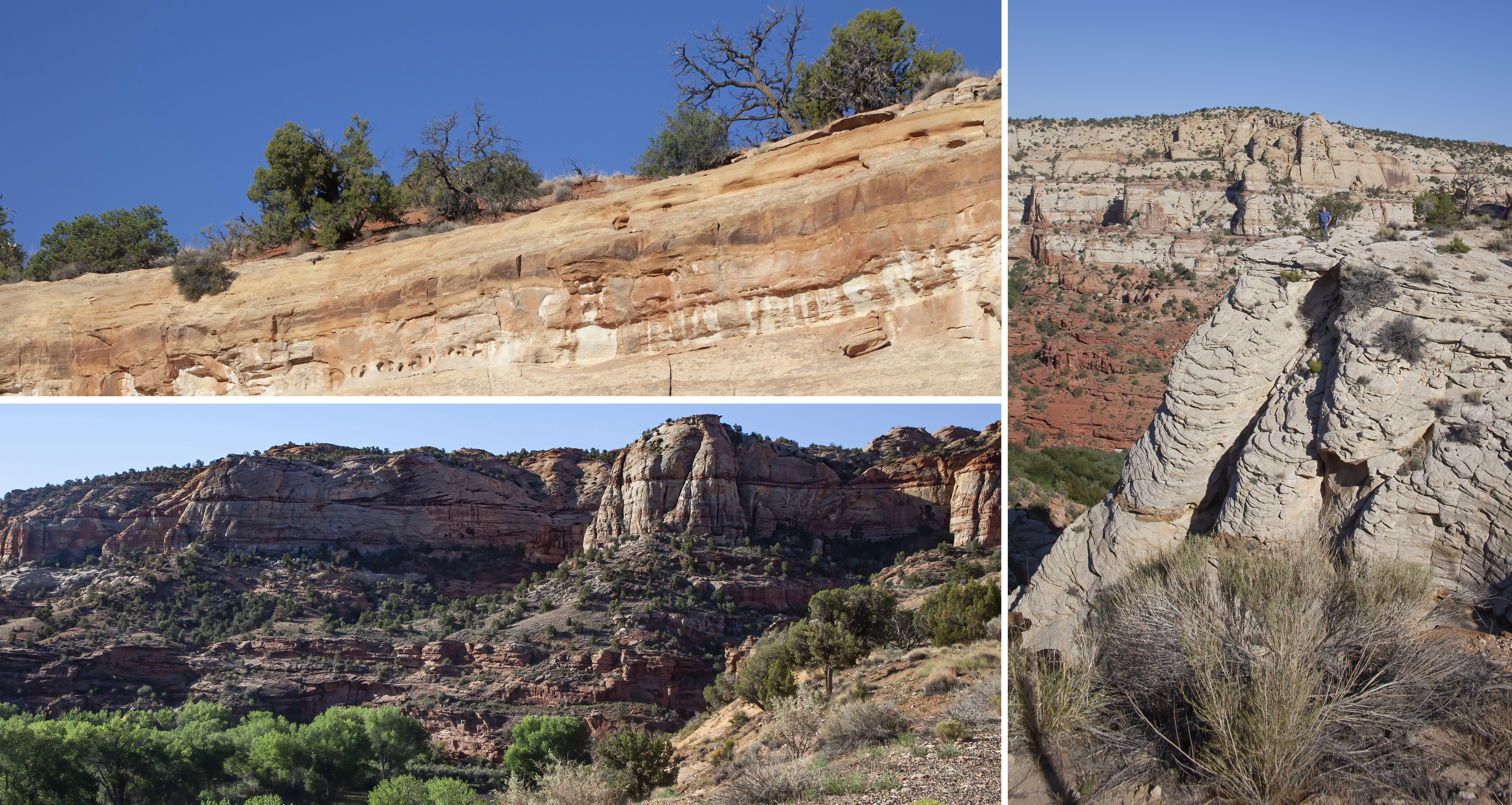 |
| Such an interesting place |
There wasn’t much in the way of wildlife (I mean, almost nothing!), but, it was still a great drive.
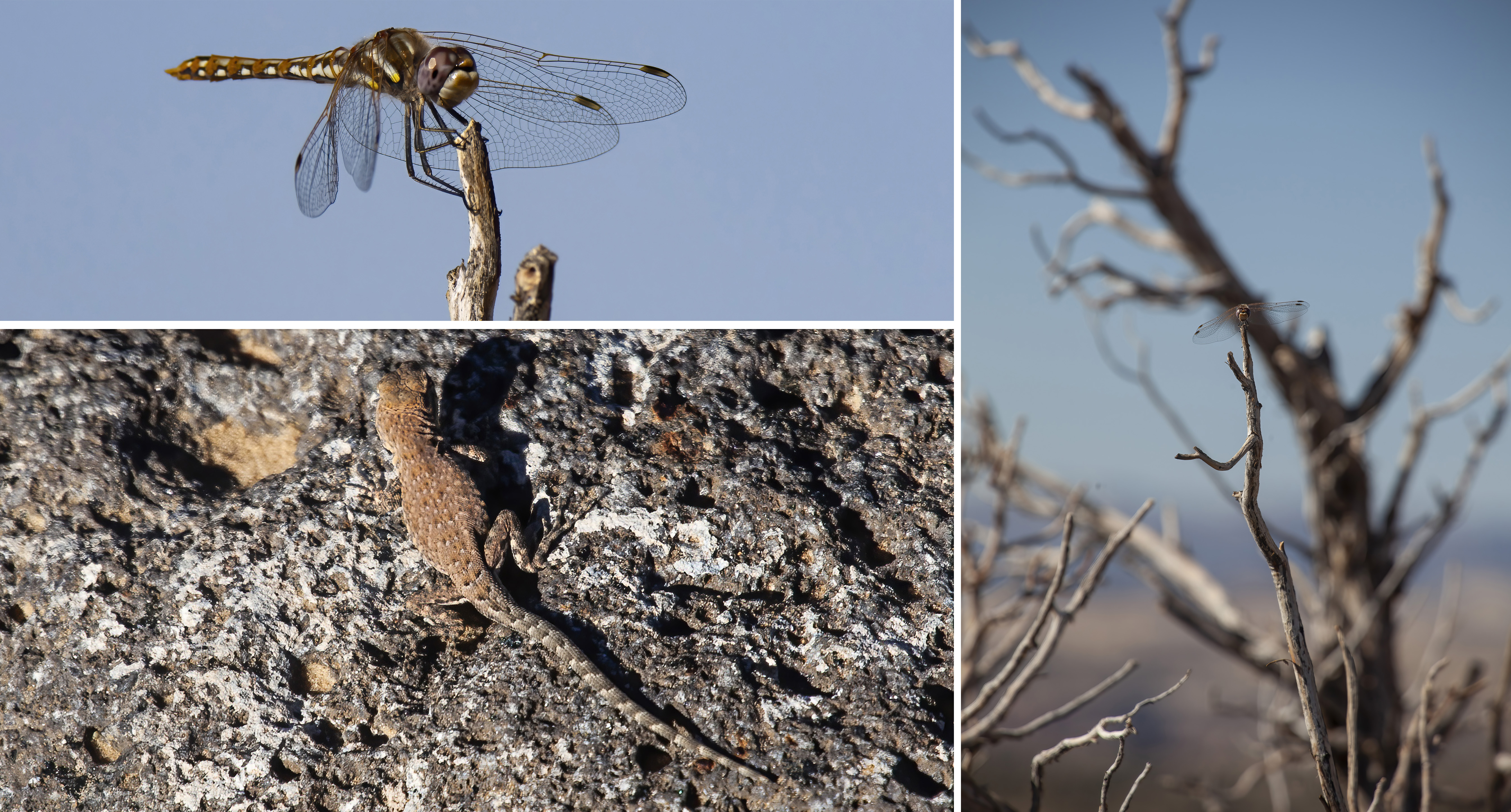 |
| Top, right: Variegated Meadowhawk; Bottom left: Western Side-blotched Lizard |
We didn’t stop much, except to take some photos …
 |
| Photos: Scott Stevens |
… and to visit the lovely little Anasazi State Park Museum in Boulder that I mentioned earlier …
 |
| Reconstructed dwelling on the Museum grounds |
Scott was hoping to find Indian tacos, but that wasn’t to be. But, we had a delicious Mexican lunch at Chak Balam Mexican Restaurant in Torrey. That’s where we would be based while we spent the afternoon and evening in Capitol Reef National Park. But, that’s my next post!
 |
| Capitol Reef National Park |
Trip date: August 21-24, 2022
No comments:
Post a Comment