 |
| Lake Powell from Wahweap |
Now, let's talk about Lake Powell.
I lived in Arizona for three and a half years and, yet, never, ventured onto Lake Powell. It was about time. Plus, the hotel at the Marina had availability. So, we stayed for one night and took a brief scenic boat ride to Antelope Canyon (the part that is under water).
 |
| Photo: Copernicus Sentinel-2, ESA |
Lake Powell, a huge manmade reservoir on the Colorado River, straddles the border between Utah and Arizona with most of it located in Utah located in Utah. Lake Powell is the second largest man-made reservoir by maximum water capacity in the United States behind Lake Mead.
Interestingly, Lake Powell is just above the Grand Canyon and Lake Mead is just below.
Ya gotta love the Rocky Mountains' ability to generate water and send it along via the Colorado River.
Lake Powell stores 24,322,000 acre-feet of water when full, which I assure you it is not right now. In fact, it is so low that many of the boat tours have had to be altered and the walk from the docks is very, very long.
 |
| Lake Powell |
Lake Powell was created by the flooding of Glen Canyon by the Glen Canyon Dam, which also led to the creation of Glen Canyon National Recreation Area. The reservoir is named for explorer John Wesley Powell, the one-armed American Civil War veteran who explored the Colorado River through the Grand Canyon via three wooden boats in 1869.
In the 1940s and early 1950s, the United States Bureau of Reclamation planned to construct a series of Colorado River dams on the Colorado Plateau where Colorado, Utah and Arizona come together. The Bureau selected in Echo Park, in what is now Dinosaur National Monument in Colorado.
 |
| Dinosaur National Monument |
A group of objectors led by David Brower of the Sierra Club succeeded in defeating the Bureau's bid, citing Echo Park's natural and scenic qualities as too valuable to submerge.
 |
| Rainbow Bridge isn't submerged |
But, they agreed to move the dam to Glen Canyon, a place Brower had never even visited.
When Brower later visited Glen Canyon, he saw that it possessed the same – or an even higher level – of scenic, cultural and wilderness qualities.
More than 80 side canyons in the colorful Navajo Sandstone contained clear streams, abundant wildlife, arches, natural bridges and numerous Native American archeological sites.
By then, however, it was too late to stop the Bureau from building the Glen Canyon Dam.
 |
| Before the dam |
Brower came to believe that the river should remain free. He later admitted that the loss of Glen Canyon was his life's ultimate disappointment.
Glen Canyon Dam was built to provide water to the Upper Basin states (Colorado, Utah, Wyoming and New Mexico), but with the caveat of the Colorado River Compact that specifies that the Upper Basin states are to provide a minimum annual flow of 7,500,000 acre-feet to the Lower Basin states (Arizona, Nevada and California) each year.
If the Compact had required the Upper Basin to deliver a percentage (say, 50 percent) of the flow of the Colorado in low water years, rather than a fixed amount, the burden of drought would have been spread equally between the basins and there would have been no need to build the dam.
 |
| Pushing the button |
Construction on Glen Canyon Dam began with a demolition blast keyed by the push of a button by President Dwight D. Eisenhower at his desk in the Oval Office in 1956. It took three years to build the diversion tunnels that permitted actual bridge and dam construction to begin. When a bridge across the Colorado that would allow trucks to deliver equipment and materials was completed in 1959, the town of Page was also founded.
 |
| Glen Canyon Dam construction |
Around-the-clock concrete placement started in 1960 and the last bucket of was poured in 1963.
Then, the diversion tunnels were opened and the Colorado River began to back up, forming Lake Powell. It took 11 full years to reach full capacity.
Comprising more than 5 million cubic yards of concrete, the Glen Canyon Dam is 710 feet high, with the surface elevation of the water when full at 3,700 feet above sea level.
Construction cost $155 million and 18 people died.
 |
| Glen Canyon Dam; Photo: Scott Stevens |
From 1970 to 1980, turbines and generators were installed for hydroelectricity.
 |
| Dam; Photo: Scott Stevens |
The lake level fluctuates considerably depending on seasonal snow runoff.
The all-time highest water level was reached on July 14, 1983, during one of the heaviest Colorado River floods in recorded history, in part influenced by a strong El Niño event. The lake rose to 8.34 feet above maximum capacity, with a water content of 25,757,086 acre-feet.
Colorado River flows have been below average since the year 2000, leading to lower lake levels.
In 2005 before the spring run-off, the lake reached its lowest level since filling, an elevation of 3,555.10 feet above sea level. Since then, it has fluctuated, but, on average, remains low.
In 2014, the Bureau of Reclamation reduced the Lake Powell release from 8.23 to 7.48 million acre-feet, for the first time since the lake filled in 1980. This was done due to the "equalization" guideline that stipulates that an approximately equal amount of water must be retained in both Lake Powell and Lake Mead, in order to preserve hydro-power generation capacity at both lakes.
 |
| Rock layers |
This resulted in Lake Mead declining to the lowest level on record since the 1930s.
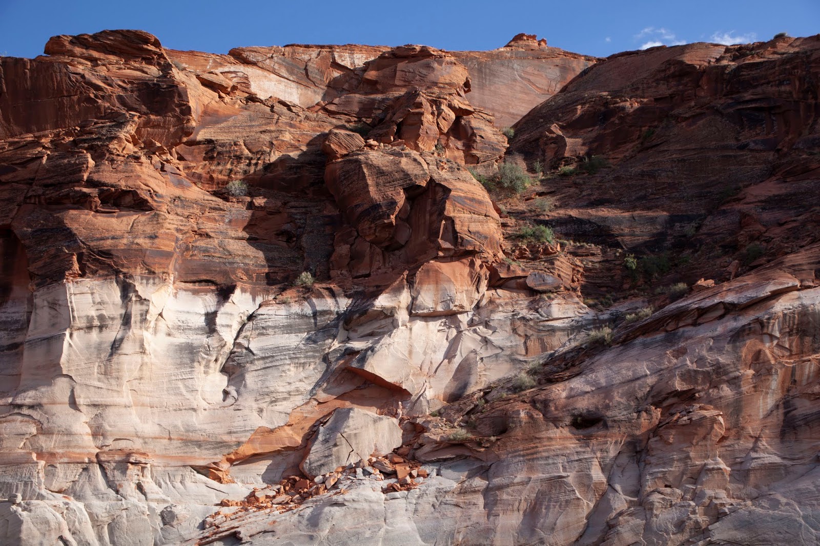
The Colorado River carved the Canyon down over an estimated five million years as the Colorado Plateau rose simultaneously. Some layers of rock are as old as 300 million years.
The Pennsylvanian, Permian, Moenkopi and Chinle Formations are the result of the ancient inland sea that covered the area. Once the sea drained, windblown sand invaded the area, creating what is known as Wingate Sandstone.
 |
| Rugged top layers |
The more recent (Jurassic Period) formations include Kayenta Sandstone, which produces the trademark blue-black "desert varnish" that streaks down many walls of the canyons. Above this is Navajo Sandstone, known for its many arches. This period also includes light yellow Entrada Sandstone and the dark brown, almost purple Carmel Formation.
 |
| Canyon wall against a beautiful sky |
These latter two can be seen on the tops of mesas around Wahweap and the crown of Castle Rock and Tower Butte. Above these layers lie the sandstone, conglomerate and shale of the Straight Cliffs Formation that underlies the Kaiparowits Plateau and San Rafael Swell to the north of the lake.
 |
| Canyon Wall |
The Lake's main body stretches up Glen Canyon, but has also filled more than 90 side canyons. The lake also stretches up the Escalante River and San Juan River where they merge into the main Colorado River.
 |
| Lake Powell |
Glen Canyon National Recreation Area draws more than two million visitors annually.
Recreational activities include boating, fishing, waterskiing, jet-skiing and hiking. Many people camp, but a large number rent houseboats on the lake.
While we were there, we saw many moored boats, but actual activity on the lake was relatively light. Still early in the season.
 |
| Castle Rock |
The Castle Rock Cut is one of the most important navigational channels in the lake; it was blasted as early as the 1970s to allow boaters to bypass the winding canyons between the Glen Canyon Dam and Lake Powell further upstream, saving, on average, one hour of travel time.
The cut has been deepened several times since then, to allow the use of the channel during droughts.
During the protracted 21st century drought, however, the lake has dropped so quickly on several occasions that the cut dried up during the summer tourist season, most recently in 2013. Continued deepening of the Castle Rock cut has been criticized for its high cost, but boaters and the National Park Service argue that it improves safety, saves millions of dollars in fuel and improves emergency response time.
 |
| The boat ride follows Canyon walls |
Our room at the Lake Powell Resort at the Wahweap Marina was very nice with access to two pools. It was quite hot – approaching 90 when we arrived, but cooled down a bit in the afternoon.
 |
| Photo: Lake Powell Resorts and Marina |
As I said, we took a boat tour. Ours just under two hours long; some of the tours are as long as seven hours. We simply crossed part of the lake, made a sharp turn near the dam and then followed the winding Antelope Canyon until it became too narrow for the boat.
The scenery was fairly consistent throughout; our rafting trip through the Grand Canyon did a much better job of showing off the variety of the rock formations.
 |
| Canyon walls from the Colorado in the Grand Canyon |
We had just two brief wildlife sightings – a flock of ducks that were hard to ID (Common Mergansers?) and some Western Willets in breeding plumage.
 |
| Lake Powell Wildlife |
It was a nice afternoon: not really exciting, but pleasant.
 |
| Antelope Canyon |
Trip date: April 25-28, 2019


No comments:
Post a Comment