 |
| The Grand Canyon |
 |
| The view driving toward Monument valley always stuns |
... because the sky was hazy and I really wanted to get to the Canyon.
 |
| It was a bit hazy |
Well, OK, I did take a few photos.
 |
| How can you not take photos |
EveningI didn't arrive at Grand Canyon until around 4:00 p.m., so I just did a little touring.
 |
| A pretty evening |
It was too late to get all the way to Hermit's Rest (the shuttle didn't go all the way), so I opted for sunset at the farthest overlook.
Sunset to the west, it turns out, is kind of stupid for photography because the Canyon is in shadows. Next time, go east.
 |
| This is what you get (the black is the Canyon) |
Then, off to bed for a big hike the next day.
I didn't really plan as well as I thought. I wanted to leave at sunrise, but I didn't actually figure in the fact that Arizona doesn't do daylight savings time.
 |
| I never know what time it is in Arizona! |
So, I got out a smidge later than I hoped, plus it took a bit longer to park and find the trailhead than I thought. I didn't actually put foot on trail until 7:15 a.m.
 |
| Still in morning shadows |
I carried lots of water because water is often turned off in the fall. It was still running, so I could have done with fewer bottles and just refilled at the stops along the way. Oh, well, better safe than sorry.
 |
| The trail follows the creek |
The hike is on the Bright Angel Trail, one of the two main trails that go from the South Rim to the bottom of the Grand Canyon.
Bright Angel descends 4, 314 feet in 9.9 miles.
The top part is quite steep with many switchbacks steep until it meets up with Bright Angel Creek. Then it levels out for awhile before getting steep again as it heads to the bottom.
 |
| The Bright Angel Trail |
The Bright Angel is the trail that the mules take (which means dodging poop and puddles). The other trail is the Kaibab, which is shorter and steeper than the Bright Angel. It is good for going down to the bottom but not for a partial loop. It's tough to come up.
 |
| You gotta let 'em pass so they'll get out of the way |
My plan was to hike to Indian Garden, which is about half way in distance, but two thirds of the way in elevation. It's a nice stopping point because it has shade and, during warm weather, water, plus a few picnic tables. It also has a campground.
 |
| Indian Garden |
I decided, because it's a 3,000 foot elevation change in 4.9 miles, to allow double the time to hike up than to hike down. I was very concerned about getting out before sunset (which was at 5:52 that day). I don't like hiking in the dark.
 |
| The trail in Indian Garden |
The hike down was cool and fairly easy, in shade almost the whole way.
 |
| Pleasant going |
Of course, I was slower than everyone. It really irks me that I hike slowly, but I am just not fond of tripping or falling and I have to pick my way carefully.
I reached Indian Garden in about three and a half hours and started out toward Plateau Point (a trail sput that has a good overlook), which was in full sun and pretty warm.
 |
| Indian Garden |
But, I decided I might not have time, so I turned back. Darn if it didn't take me less time to hike up than down. This time, I just blew past everyone (advantages of living at 6,000 ft.; 5,000 elevation doesn't wind you as much).
 |
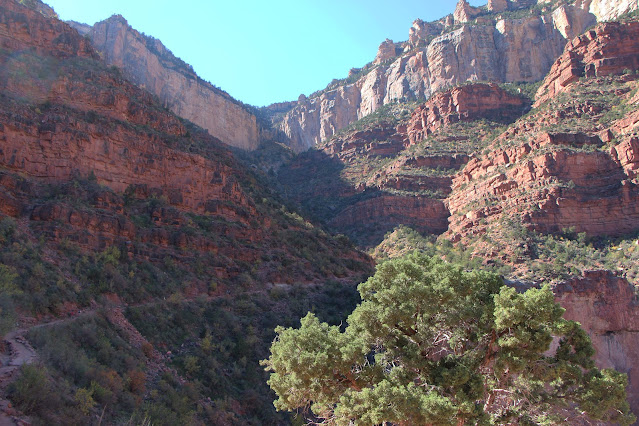
| The Bright Angel Trail looking up and down |
I could have done Plateau Point after all.
 |
| The trail that goes to the edge in the middle of the picture goes to Plateau Point |
Anyway, it took 7.5 hours for 9-10 miles; I burned a measly 1,868 calories in that time!!!
 |
| Still obsessed with calorie burn |
I wasn't even particularly tired, probably because of the shade and cool, but not cold temperatures.
 |
| October is a great time to go |
So, I came out with time to spare and, after a shower and changing into warmer clothes, took a 2.5 mile hike long the Rim.
 |
| The South Rim |
I had a salad at the Arizona Grill (my only restaurant meal on my whole trip) and then hung around the main area (by the Bright Angel Lodge) on the South Rim for sunset.
 |
| The Bright Angel Lodge |
It did not disappoint ...
 |
| Wow! |
... it was a truly beautiful sunset ...
 |
| Just wow! |
Now it caught up with me. I was pretty tired, so I crashed for the night.
The next day was cold and windy. I had hit the last warm day at the Grand Canyon for awhile, so leaving was OK. It was a 10-hour drive home with super high winds (I couldn't get me car door open at one stop), but sunny.
 |
| I stopped briefly at Four Corners; it wasn't really worth it |
Another great trip. I think I'll go the the Grand Canyon at least once every year!
 |
| One of the prettiest places on Earth |
Trip date: October 25-29, 2013
No comments:
Post a Comment