 |
| Horseshoe Bend |
So, we packed (carefully checking our lists) all our stuff for Grand Canyon
rafting, charged up all our batteries and headed out. First stop: Mesa Verde
National Park in southwestern Colorado. Interestingly, this is another place we
visited on that 1975 second honeymoon. It hasn’t changed a lot, but it has
changed some.
 |
| Scott and me at Mesa Verde, 1975 |
“Discovered" in the 1800s and established by President
Theodore Roosevelt as a National Park in 1906, Mesa Verde protects some of the
best preserved Ancestral Puebloan archaeological sites in the United States.
 |
| Mesa Verde |
The
52,485-acre park houses more than 4,300 sites, including 600 cliff dwellings, mesa-top
pit houses, pueblos, masonry towers and farming structures. Mesa Verde’s Cliff
Palace is thought to be the largest cliff dwelling in North America.
 |
| A magnificent ancient village |
Mesa Verde, Spanish for “green table” for the wooded mesa
top, provides insight into the lives of the Ancestral Pueblo people who made it
their home for more than 700 years, from 600 to 1300. Then, within a generation
or two, they left their homes and moved away, probably because of prolonged
drought that made it impossible to grow their primary staple, corn.
 |
| The mesa top |
This visit was a quick one, we just drove the mesa-top roads
and looked at the ruins from overlooks. The best way to visit is to either hike
or take a ranger-led tour of one or more of the major cliff dwellings (Cliff
Palace, Balcony House or Long House). Because the season had just begun, there
was only one tour available while we were there – Balcony House. So, if you
want extensive tours, don’t plan to visit Mesa Verde until after Memorial Day.
 |
| Views of the ruins |
One of the major recent changes at Mesa Verde is that Spruce
Tree House, which used to be open for self-guided tours, is now closed the
public because the overhanging cliff is unstable. There was a major – and
unexpected – rockfall in 2015 while tourists were in the site. No one was
injured, but it could have been tragic. The Park Service is now evaluating the
area to determine if it can be reopened and what fortifications will be needed
to make it safe.
 |
| A wonderful National Park |
As I said, the season had just begun. As a result, some things weren't open and services were lacking.
 |
| Ladder for moving to another level |
For example, we got information from the hotel desk
clerk about the nearby café’s operating hours that conflicted with information
at the café itself – and that conflicted with what was actually going on. I am
sure it is all worked out by now. But, we were never at the café at the
right time.
We had lunch at the Spruce Tree Terrace (fabulous Indian tacos) and
dinner at the Far View Lodge (I think I just had an appetizer), where we
stayed. The hotel is a nice location with a pretty view. Since it takes a long
time to drive into Mesa Verde, it is nice to stay onsite.
 |
| A blue tail |
And Mountain Bluebirds ...
 |
| A Bluebird |
After our quick stop at Mesa Verde, we headed off towards
Marble Canyon. It was a fairly uneventful drive, except for a great part of the
road that winds through a canyon after Page, Arizona, before the turn to Marble
Canyon.
Marble Canyon sits between the Vermillion Cliffs to the south and Lees
Ferry to the north. We visited both.
 |
| Vivid red cliffs |
Vermilion Cliffs National Monument comprises 293,689 acres,
including the Paria Plateau, Coyote Buttes, Paria Canyon and the actual cliffs.
Established in 2000 by President Bill Clinton, Vermilion Cliffs comprises northern
Arizona lands that were already under the management of the U.S. Government.
 |
| Spires |
The
monument is administered by the U.S. Bureau of Land Management. That would have
made it perfect to do some drone photography, except that it was windy.
 |
| Looks like a dragon with its tongue sticking out! |
The Vermilion Cliffs are steep eroded escarpments of sandstone, siltstone, limestone and shale that rise as much as 3,000 feet above the valley floor. These sedimentary rocks have been deeply eroded for millions
of years, exposing layers and layers of richly colored rock.
Mesas, buttes, interesting rock
formations and large tablelands are interspersed with steep canyons.
A few small streams provide enough moisture to support a sampling of wildlife,
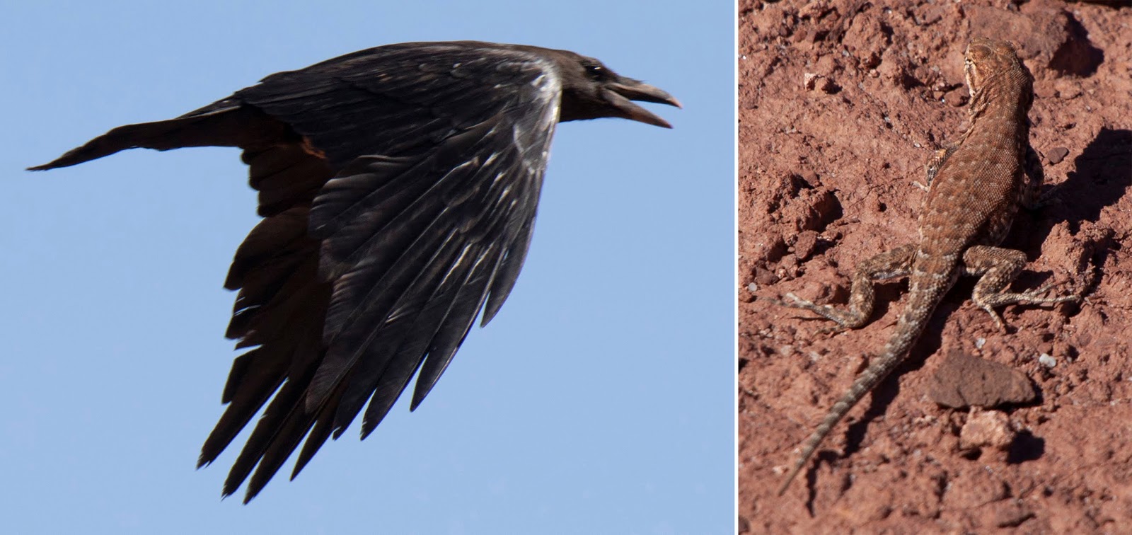
although we didn’t see much but Common Ravens, Red-Tailed Hawks and Plateau Fence Lizards.
 |
| Common Raven and Plateau Fence Lizard |
Human settlement in the region dates back 12,000 years, and
hundreds of Native American pueblos are spread across Vermillion Cliffs,
including the remains of villages with houses, granaries and burial areas. The
National Monument contains a large number of rock art sites; many of these
petroglyphs are believed to be among the oldest in the United States.
 |
| An old structure |
The first explorers in the region were from the 1776 Spanish
Dominguez-Escalante Expedition. Mormon explorers visited the area in the 1860s,
some of remaining to settle there. In 1887, they built Lees Ferry, one of the
first ferry crossings on the Colorado River – and the place where we were to
embark upon our raft trip the next morning. That same year, John Wesley Powell began
scientific explorations of the Colorado River plateau.
 |
| River reflection |
Below the Vermilion cliffs is the historic "Honeymoon
Trail," a wagon route for Mormons who traveled to the temple in St.
George, Utah, to have their marriages sanctified. Today, the area surrounding
the monument is relatively unspoiled with virtually no permanent inhabitants and
limited road access.
 |
| Cliff views |
We explored a little, including stopping at Navajo Bridge to
look at the Colorado River (and watch another Arizona River Runners trip take
off).
 |
| Rafters |
Navajo Bridge is actually two bridges. The older bridge was
dedicated in 1929 as the Grand Canyon Bridge; the name was changed to Navajo
Bridge five years later in 1934. The original bridge is 834 feet long and 18
feet wide with a maximum height of 467 feet from the canyon floor. By 1990, traffic
flow had gotten too great for the original bridge and a new bridge was built.
The new bridge is 909 feet long, 44 feet wide and 470 feet high. The original bridge
is now open only for pedestrian and equestrian traffic. It has been designated as a Historic Civil Engineering Landmark and was placed on the
National Register of Historic Places in 1981.
 |
| Navajo Bridge |
It is well known that many of the Grand Canyon’s California
Condors hang out at Navajo Bridge but, alas, we saw none.
Lees Ferry, just down the road from the Navajo Bridge, is where
the Paria River joins the Colorado River. Sixteen miles upstream is the Glen
Canyon Dam, which regulates the flow of the Colorado River through the Grand
Canyon.
 |
| The Riffles |
Lees Ferry is the only place in more than 260 miles where
the Colorado River is not hemmed in by sheer canyon walls and, thus, is the
only place in the area where one could cross the river. There used to be another
ford four miles away, but is now under Lake Powell, which was created by the
Glen Canyon Dam.
Starting in the mid-19th century, there was an actual ferry
operated by John Doyle Lee, for whom the area was named.
I guess if there hadn’t
been an actual ferry, the area would have been called Navajo Ford or something like
that.
Boat service at Lees Ferry continued for more than 60 years before being
superseded by the Navajo Bridge, which greatly improved the ability to cross
the River.
 |
| Navajo Bridge from below |
Since the 1920s, Lees Ferry has been the principal point at
which river flow is measured to determine water allocations in the
246,000-square-mile Colorado River basin. While we were exploring the area, I
saw scientists checking flow and water quality.
Lees Ferry is within the Glen Canyon National Recreation
Area and is considered the northernmost end of Grand Canyon National Park. It
lies 689 miles upstream of the Colorado's mouth at the Gulf of California, at
the approximate halfway mark of the river's length. As I discussed in my blog
about Colorado National Monument, the Colorado River begins in Colorado, but
was formerly called the Grand River until it merged with the Green River in
Utah.
 |
| The Grand Canyon starts here |
There is some irony to the River being called the GRAND in Colorado and the
COLORADO in the Grand Canyon. Of course, the River’s name comes from its color,
which can be a deep reddish brown when it is agitated or being inundated with
sediment. Fortunately, during our trip, there had been no rain and it was not “colorado.”
It was a beautiful blue-green.
 |
| Clear, clear water |
As I mentioned, the area has been inhabited for at least
12,000 years. Indigenous peoples generally did not make extensive use of the Lees
Ferry area and other canyon stretches of the Colorado River, preferring the
open plains for hunting. However, it was a valuable livestock watering point –
and, thus, disputed territory -- for the Navajos and Paiutes.
 |
| Cold water on a hot day |
The area has been visited by Spaniards, Mormons, gold prospectors
and, now, primarily tourists (like us).
 |
| Trout |
In addition to being the launching point for Grand Canyon
rafting trips, Lees Ferry is a “Blue Ribbon” fishery because the cold, clear
water from Glen Canyon Dam is ideal for
Rainbow Trout. The river has been stocked with Rainbows since 1964.
Lees Ferry
is also the ending point for backpacking and canyoneering trips down the Paria
River, which features historic petroglyphs, slot canyons, waterfalls and
natural bridges.
The steep slots are famous for flash flooding, so hikers must
be very careful.
While we were there checking the area out, we saw lots of
rafters getting ready to go – both commercial and private (yep, you can do the
Canyon on your own – something I would hope requires some sort of expertise to
get a permit). We even saw some Arizona River Runners rafts, which I think may
have been on a seven- or eight-day trip. This slightly longer trip travels the same
route but has more stops and hiking. These were probably the rafts we saw again
(and camped next to one night) along the River.
 |
| Embarking on a trip |
Our final destination the day before we took off into the
Grand Canyon was Horseshoe Bend, back a little way up the road toward Page,
Arizona. Five miles downstream from the Glen Canyon Dam and Lake Powell,
Horseshoe Bend is an almost-circular (270 degrees) canyon carved by the
Colorado River around a large butte. You reach it via a ¾-mile hike to a 1,100-foot
cliff overlook.
 |
| Horseshoe Bend |
When we arrived, it was not clear how far the walk was. It
initially looked like a short jaunt. But, once we crested the hill where there
is a gazebo that we originally thought was an overlook, we saw that we had
further to go. Scott almost turned back, but we figured we’d press on. Since it
was a spur-of-the-moment visit, we really weren’t prepared. One should really
take water and wear a hat. Fortunately, it was late in the day, so we were fine
without water. It was, however, hot. And crowded. Very crowded with tourists,
some of whom were wearing questionable shoes or clothes for such a walk. I
mean, high heels on a steep gravel trail? Leather pants in 90+ degree weather? Really?
 |
| Another view |
When we reached the overlook, we realized that you can’t
really see the whole bend in the River unless you hang over the edge or
scramble up a nearby outcrop (and I am only guessing that the view is better
there – I didn’t climb up). Scott did get down on the ground and hang over the
edge. I had two cameras with me, so that wasn’t really possible. And, since it
was crowded, finding a spot was difficult (at one point, a woman actually sat
on Scott’s shoulder!).
 |
| Getting the shot at any cost |
But, this is what he got ...
 |
| Photo: Scott Stevens |
Even if you can see the whole thing, you need a wide-angle
lens to capture the full width. Luckily, I took the right lens! And, cell
phones work, although cell phone photographers still annoy me. And, don’t get
me started on Ipads!
 |
| A hard shot to get |
There are no railings and, although I am not usually afraid
of heights, I did find it difficult to get right up to the edge and I was a bit
concerned about what I was actually standing on. You can’t really tell if you’re
on a solid cliff or just a fragile unsupported ledge. That can be a problem. Of
the two documented fatalities at Horseshoe Bend in the past 20 years, one was a
hiker from Greece who was standing on a thin sandstone ledge that broke off,
plunging him into the Canyon. Then, just a week before we were there, a Phoenix
man fell to his death. I couldn’t find how he happened to fall, but it didn’t
seem to be related to a crumbling ledge like the first one. I did see lots of
people standing places I wouldn’t go.
 |
| The crowd |
Even with the hot walk, limited view and crowds, the trek
out was well worth it. The view is spectacular. And, at one point, we saw three
tour boats zipping around the butte.
 |
| Multiple views |
The night before our trip, we stayed at the Marble Canyon
Lodge, one of just a few accommodations close to (actually the closest to) Lees
Ferry. It was recommended by Arizona River Runners and it was next door to
where we met our guides in the morning. It is quaint and rustic, but clean and
comfortable.
 |
| The Lodge |
We booked to stay the night before and the night the rafting trip because we did not know what time we would get back on the last day.
When we returned much earlier than we expected, they cancelled our reservation
with no penalty. That was very nice.
Speaking of reservations, the Marble Canyon Lodge doesn’t do
online reservations – you have to call. Then they write it in pencil in tiny
letters in a large ledger book. So, cancellation simply requires an eraser!
The Marble Canyon Lodge has a restaurant, where we ate
several times. The food was excellent, especially the Indian fry bread. They
didn’t have Indian tacos on the menu, but Scott manufactured some by ordering
green chili, Indian fry bread and a small salad with avocado. Then, we just put
it all together.
 |
| Yum! |
The hotel is across the highway from the Navajo reservation
and most of the employees are Navajo.
And, one more thing about reservations. When we got to
Marble Canyon, we realized that we were less than two hours from the North Rim
of the Grand Canyon. So, we took a long shot and tried to get reservations to
stay there after rafting. It worked! There was a cancellation and we got a
cabin. When we got back to Marble Canyon, we decided to try for two nights. It
worked and, even though we had to change rooms, we did get two nights on the
North Rim. That is not normally easy to do. But, that's for later ...
 |
| North Rim, Grand Canyon |
Trip date (including rafting): May 13-22, 2018


No comments:
Post a Comment