 |
| Chiricahua |
Part of the drive was down almost deserted roads through dessert and mountains. I rejoined the Interstate near Santa Fe and zipped south without much stopping. On the way I witnessed a recently started wildfire near Socorro/Escondida that I later heard burned a few homes. So, it was hot and smoky, pretty much negating any interesting photos.
I finally made it to Lordsburg right around sunset and just seven miles shy of hitting 100,000 miles on my Honda CVR. I was tired, but glad to be there.
I finally made it to Lordsburg right around sunset and just seven miles shy of hitting 100,000 miles on my Honda CVR. I was tired, but glad to be there.
Lordsburg itself doesn't seem very interesting, but it was a good (and cheap) jumping off point for several targeted areas.
The next morning, I headed out early for Chiricahua National Monument, which is in Arizona less than two hours from Lordsburg. We didn't visit it on our last trip to southern Arizona because of some road closures. But, everything was open this time.
The first thing I did was capture the moment my odometer turned over to 100,000 miles.
 |
| Yay! |
It happened on a stretch of Interstate 10 that traverses a flat desert area surrounded by mountains. Although it was only slightly dusty, it is -- judging from the many, many warning signs -- a major dust/sand storm corridor. To get to Chiricahua from New Mexico on paved roads (more about the unpaved roads in my next blog), you have to drive past the park, which you can see in the distance, and come in from the west side.
 |
| Looks like a sleeping man |
After I reached Willcox, Arizona, I pulled off on the long road to Chiricahua, which passes through desert cattle ranches.
 |
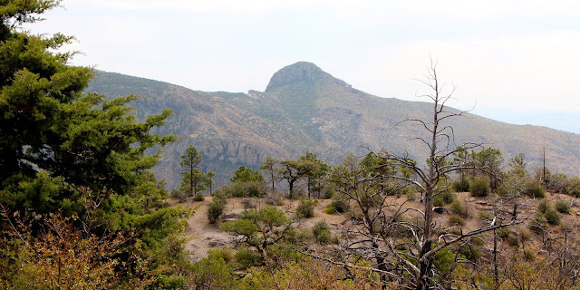
| Distant mountains |
As you would expect, it's a great area for raptors -- I saw quite a few American Kestrels and Red-tailed Hawks, some of which even posed for me.
 |
| Red-tailed Hawk |
I wanted to get to Chiricahua early and actually did because Arizona doesn't participate in Daylight Saving Time, so I gained an hour. The Visitor Center wasn't even open (the website says 8:30-4:30 MST, but it actually opens at 9:00) when I arrived and there were very few people in the park.
Chiricahua National Monument, approximately 36 miles southeast of Willcox, Arizona, was established in1924 to protect its extensive hoodoos and balancing rocks.
Chiricahua National Monument, approximately 36 miles southeast of Willcox, Arizona, was established in1924 to protect its extensive hoodoos and balancing rocks.
 |
| Hoodoos |
The Faraway Ranch, which was owned at one time by Swedish immigrants Neil and Emma Erickson, is also preserved within the monument.
 |
| On old building |
The 12,025-acre monument comprises the remains of an immense volcanic eruption that occurred 27 million years ago, laying down almost two thousand feet of dark volcanic ash and pumice that eroded into a "wonderland of rocks" including rhyolite columns.
 |
| Tumbled columns |
I drove the eight-mile-long Bonita Canyon Loop after I arrived, stopping frequently to marvel at the formations ...
 |
| Bonita Canyon |
... and to photograph some of the birds: an Acorn Woodpecker, with its funny clown face ...
 |
| Cutie |
... Mexican Jays, which are also known as Gray-Breasted Jays, and are very energetic ...
 |
| I saw lots of these |
... a bright orange/red Hepatic Tanager ...
 |
| A pretty bird |
... Common Ravens ...
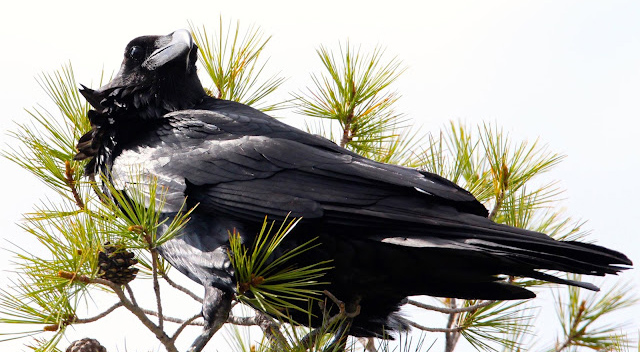 |
| A pretty Raven |
Plus an assortment or squirrels, including Rock Squirrels ...
 |
| Squirrel in the grass |
... and Gray-Collared Chipmunks ...
 |
| On the rocks |
Even though the west was experiencing high temperatures, Chiricahua was a relatively cool 70 degrees in the morning, most likely due to the elevation, which ranges from 5,100 to 7,300 feet. So the trip up Bonita Canyon Drive was very pleasant.
On the way up, I stopped at many overlooks, including Sugarloaf Mountain ...
 |
| A distant mountain |
... and Echo Canyon ...
 |
| Very impressive rocks |
I took a a short walk around the top, where there is a nature walk and several observation areas ...
 |
| A very pretty overlook |
... including a view of a mountain named "Cochise Head," after the famous leader of the Chihuicahui group of the Chiricahua Apache. An Apache War leader, he led an uprising against the American government that began in 1861 and persisted until a peace treaty in 1872. Cochise County, Arizona, where Chiricahua is located, is named after him.
 |
| Another face |
Then, I decided to go back down to the Visitor Center to see what was going on. Just after I pulled out, I was thinking that I was probably going to have to stay at least until dusk if I wanted any chance of seeing a Coatimundi, a raccoon-like animal native to South America, Central America and the southwest U.S. Adult coatis measure 13 to 27 inches from head to the base of the tail, which can be as long as their bodies. They look like a cross between a fox, squirrel and raccoon. Their long and somewhat pig-like snout has given them the nickname, "hog-nosed raccoon." Seeing one would be a thrill; photographing one would be even more thrilling. I highly doubted I would.
 |
| Photo: Getty Images |
And, not a minute later, one crossed the road right in front of my car! I slammed on the brakes, turned around and went back to look for it -- including walking around the nature trail where it might have gone. I never saw it again and I got no pictures. I was kicking myself for not setting up my GoPro for the drive -- so that I could catch animals that cross the road. I set it up for the drive down (and back up later), but never had another animal sighting like that one.
 |
| Pretty rocks |
The wildlife was a bit disappointing, but, by now it was mid-day and getting a bit warm (high 80s/low 90s). I did see some pretty magnificent lizards, including the Yarrows Spiny Lizard ...
 |
| A pretty lizard |
... Clark's Spiny Lizard ...
 |
| Look at that face |
... and Chihuahuan Spotted Whiptail ...
 |
| A pretty lizard |
Plus, I did a grab a few birds (ironically the same birds I had photographed in my back yard), including a Spotted Towhee ...
 |
| Pretty red eyes |
... and a Black-headed Grosbeak ...
 |
| Black-headed Grosbeak |
But, most birds were just too fast for me. The desert blooms, including Barrel Cactus ...
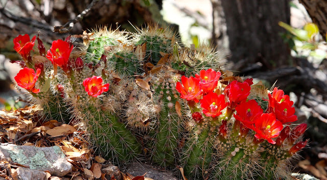 |
| Pretty red flowers |
... and Agave ...
 |
| An interesting plant |
... were a bit more cooperative, as were the magnificent rocks ...
 |
| Window to the other side |
I call this one "The Scream" ...
 |
| Funny rocks |
During my hike, some thunderheads started to form and I heard distant thunder, so I rushed to get out of the canyon before the deluge. It didn't rain. Fortunately, I followed the advice from the Park Service to take the trail counter clockwise because the Echo Canyon Trail down is steeper than the Ed Riggs Trail up (they are connected by the flat Hailstone Trail, a name that gave me a little pause as it was thundering).
I spent the rest of the afternoon exploring ...
I spent the rest of the afternoon exploring ...
driving down the Bonita Canyon Scenic Drive. To see a video, click here.
I had my lunch at Faraway ranch in the company of very curious Mexican Jays.
 |
| One grabbed some of my grapes |
 |
| A cute face |
... I also drove around in the open plains outside the entrance, where the animals are different. I saw more Red-tailed Hawks ...
 |
| This one has a very red tail |
... Greater Roadrunners (including one that thought it was hiding) ...
 |
| "You can't see me" |
... Loggerhead Shrikes ...
 |
| On a wire |
... Western Kingbirds ...
 |
| One of my Colorado birds |
... and an adorable Swift Fox that ran off before I could photograph it.
Although I witnessed some really beautiful late afternoon sun, a storm rolled in before sundown, so I didn't get my red sunset shots.
 |
| Pretty sky |
But, I did get some great pre-storm pix.
 |
| Nice light |
It was an enjoyable day at Chiricahua -- and I got a free carwash as I drove back to the hotel to plan my next day.
 |
| Rain! |
Trip date: June 10-14, 2016
No comments:
Post a Comment