Tuesday, April 18, 2017

Carlsbad Caverns

The next morning, we headed to Carlsbad Caverns National Park, which I blogged about in 2014. Click here to read.

Nice sign
As I mentioned then, my recommendation is to skip the tour and walk the caverns yourself, starting early to avoid the crowd. I like to walk in (it’s a little over a mile with an 800-foot drop), tour the caverns (about another two miles) and take the elevator out. 

We saw a lot of people walking out – but that’s quite a climb and why take that extra time? By the way, entry to cave is free with a National Park Pass, so you could really spend a lot of time in and out of the caves if you wished.

Cave opening
This time it was a bit early for bats, but the cave entrance was abuzz with Cave Swallows. These little guys never slow down (more about that later).

Back to the caverns ...

Shooting in a cave is tricky
Carlsbad Cavern is the fifth largest cave chamber in North America and the 28th largest in the world. 

The part you can tour includes The Big Room, a natural limestone chamber almost 4,000 feet long, 625 feet wide and 255 feet high at the highest point. 

The Park actually includes more than 100 caverns and isn’t completely explored yet.

With my newer camera, I got much better photographs than last time I toured the cave. 

It’s a bit tricky because it is so dark – you just need to be very steady. I could have taken a tripod (we saw a person with one), but I think that is intrusive to people trying to pass you on the narrow trails. 

Walking sticks are NOT allowed, probably because prolonged use would damage the asphalt trail. I also encountered this in Machu Picchu.

Some of my best shots
I won't attempt to identify all the formations -- there are just too many -- stalactites, stalagmites, columns, smaller caves, pools ... 

But, I would like to point out a few interesting features.


Interesting mineral deposits
For example, there are a number of small pools in the cavern. 


Before we went in the cave, the ranger told us that they used to ENCOURAGE people to throw coins into them. Now, of course, it is forbidden because all foreign objects are potentially damaging to a cave. 
The water in the pools is exceptionally clear and there is no wind to create ripples, so it can be difficult to even gauge how deep the pools are.

The one below had such a phenomenal reflection that it was hard to tell what was real and what was reflected.

Pool
The cave's name comes from the nearby town of Carlsbad, which is named after the Czech town formerly known by the German name Karlsbad and now known by the Czech name Karlovy Vary, both of which mean "Charles' Bath[s]." 

I always think the cave is going to be cold -- at some time in my life I must have visited a cold, damp cave or perhaps my sensibilities have changed since I live in a cooler climate now. So, we took jackets. Not needed. It was a tiny bit too warm/steamy for a light jacket. It's probably too cool for shorts, but jeans/capris and a tee shirt are fine. I do recommend good shoes -- trails can be slick. 

I love this
There aren't many artifacts in the cave, but there is a cool circa 1920s ladder. In the early days, tourists entered the cave by ladders or (sometimes) in "guano buckets," which were also used to remove bat guano, which was sold as fertilizer. 

In 1932, the National Park opened a large Visitor Center that contained two elevators to take visitors in and out of the caverns below. It included a cafeteria, waiting room, museum and first aid area. There are still elevators. And, there is still a small snack bar/gift shop in the cavern, but it seems less expansive than it was. 

Now it just offers pre-packaged sandwiches and bottled drinks. I suggest going up to the ground-level cafeteria if you want eat at the Park. They have some pretty fiery salsa for their New Mexican food. That's one thing about New Mexico; their food is unabashedly hot. And, generally yummy -- even in a cafeteria.

Snack bar
After we toured the cavern, we went back down to the entrance to try to get some pictures of the Cave Swallows. The ranger even let us bypass the safety/rules talk given to anyone entering the cave since we had already participated once.

Flocks fly dramatically in and out of the cavern, sometimes swooping right by your head but never ever stopping.

Cave Swallows; Photo: Caty Stevens
Trying to get a picture was an exercise in futility. Caty was a little bit luckier (or more skilled) and was able to get the shot at the right at the cave entrance.

Cave Swallows first appeared in what is now the National Park before 1930, but didn't occupy the cave until 1966. 

A close relative of, but far less common than, the Cliff Swallow, Cave Swallows arrive at the caverns from Southern Mexico, El Salvador and Costa Rica in early February and stay as late as late November. They eat insects that they catch in flight. 

Coexisting with bats, they fly during the day. The bats fly at night.

Cliff Swallows nest just inside the cave entrance. Unlike a Cliff Swallow's nest, a Cave Swallow's nest is not fully enclosed. It is shaped like a small half-cup constructed of mud and plant fibers, and lined with feathers.
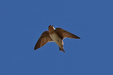
Got one!
I was finally able to get ONE semi-good picture by randomly aiming my camera into a large group flying overhead. Sometimes you just have to try a lot of techniques until one works out. We spent an inordinate amount of time getting the few shots we got, but we had to move on.

So, after the cavern tour, we decided to drive the nine-and-a-half-mile scenic desert loop. It didn’t really show us much more than we could see from the regular road. 

I guess it would have been interesting if I had never driven in the desert. But, I have – many, many times. 

Or, if we had seen a frickin’ Bobcat, Mountain Lion, Golden Eagle, Roadrunner or Javelina. Or even a unique raptor. But, we didn’t.

Pretty


Trip date: April 6-10, 2017

Organ Mountains/Desert Peaks National Monument

Since we had gotten an early start, we had quite a bit of day ahead of us before we needed to head out to Carlsbad. So, since we had seen the dunes and we didn’t anticipate that animal activity would pick up as the day got sunnier, we decided to visit a new National Monument that neither of us had been to.

Interesting rocks
Organ Mountains/Desert Peaks National Monument (that’s a mouthful) is managed by the Bureau of Land Management as part of the National Landscape Conservation System. National Monuments can be managed by the NPS or BLM and, often, you don’t hear as much about the BLM sites. But, many are spectacular.

And, “spectacular” is the word used on the reviews we read online about Organ Mountains/Desert Peaks National Monument. So, why not go?

Rugged butte
The 496,330-acre monument was designated by President Obama in 2014. 

It protects a variety of geological, paleontological and archaeological resources in the Chihuahua Desert. 

Half of the monument is designated wilderness and closed to development or cars. It has three big units near Las Cruces. 

The protected area includes five mountain ranges – Robledo, Sierra de las Uvas, Doña Ana, Organ and Potrillo. 

The Monument protects archaeological/cultural sites, including WWII bomber target practice sites, Apollo Mission astronaut training areas and 22 miles of the Butterfield Stagecoach Trail. 

There are 243 known archeological sites, including some of the earliest Native American settlements and petroglyphs made by three different tribes.

Before the Gadsden Purchase, Organ Mountains/Desert Peaks included the border with Mexico. More recently the area was used by both Billy the Kid and Geronimo.

A wide view; Photo: Caty Stevens
Of course, we didn’t visit any of those sites. We did, however, take a lovely short hike to Dripping Springs, which was the site of an early tourist resort. 

An old tourist spot; Photo: Caty Stevens
Colonel Eugene Van Patten built Van Patten's Mountain Camp resort near the spring in the 1870s. Thirty years later, Dr. Nathan Boyd established a tuberculosis sanatorium nearby. There was no cure for tuberculosis at the time, but patients did benefit from clean air, good food, clean water, tranquility and sunshine, all of which were abundant at the resort.

Old buildings; Photo: Caty Stevens
Van Patten was the nephew of John Butterfield, founder of the Butterfield Stagecoach Overland Mail Company, which ran through the area. Van Patten worked for his his uncle as a laborer, driver, conductor, station keeper and Indian fighter. He was then a Pony Express rider and a bugler for the Confederate Army of New Mexico. After being wounded in battle, he took charge of a Confederate hospital.

A building up against the cliff
Van Patten, whose wife was Native American and Spanish, led opposition to efforts to evict Native Americans from their land. H
e created a unit of the New Mexico National Guard and organized a New Mexico branch of Teddy Roosevelt's "Rough Riders" for the Spanish-American War. He also served as the sheriff and was active in bringing the railroad to Las Cruces. He was a co-founder of New Mexico State University.

The Dripping Springs resort was a two-story 14-room hotel with dining and recreational facilities. Made of native rock from the canyon, it was held together with mud-mixing plaster. 

The grounds were landscaped and featured a gazebo bandstand. Interior ceilings were covered with tightly stretched muslin and patterned wallpaper decorated many of the rooms. 

There was a livery, where guests could stable horses and mules and park coaches and wagons. He drew staff from the Tortugas Indians.

More ruins; Photo: Caty Stevens
Resort guests guests included lawman Pat Garrett, Mexican revolutionary Pancho Villa and, possibly, Billy the Kid. 

Old barbed wire
After Van Patten rented land to Boyd for his sanatorium, he and Van Patten became entangled in a legal dispute over land and water. 


By 1916, Van Patten, bankrupted by legal costs, turned Dripping Springs over to Boyd, selling it to him for $1.00. 

Boyd, educated in San Francisco, moved to Dripping Springs after his scheme to build a dam and sell irrigation water to farmers below the dam at outrageous prices collapsed. He chose the area because his wife had tuberculosis. 

He operated the sanatorium until 1922. Later the Dripping Springs land was used for livestock.

The springs, which seep out of the rock, form a very small dripping waterfall. Based on evidence as we hiked, it appears that the stream coming from the springs can also an also become a torrent. There were a lot of downed trees and brush in the streambed.

The stream
The three-mile round-trip hike is easy, across scrubby desert and then down into the canyon by the spring.

A nice morning; Photo: Caty Stevens
The area with the ruins of the resort and the sanatorium are roped off to prevent you from walking through the buildings. Some are badly broken down and some are remarkably intact. Some, even still have screen in the doors and windows.

Screen door
The trail is referred to as a "loop," but it's all pretty much the same route out and back with just a little loop at the end.

There isn't a lot of shade along the way, so in the summer time, it might not be as pleasant as the balmy, breezy day we hiked.

We saw a few critters along the route …

Chipping Sparrow
Mule Deer
Black-throated Sparrow
Hermit Thrush hiding beneath the springs
More Say’s Phoebes
And, some really pretty cactus flowers
While the hike had been described as “spectacular,” I would have to say it was only pretty. But, then, I live in Colorado and I have traveled to many truly spectacular places, so I am very jaded.

A nice walk; Photo by Caty Stevens
Now, however, it was time to hit the road. It’s a long and very isolated drive to Whites City. We opted to swing through El Paso (sorry, NOT a pretty city) and up past Guadalupe Mountains. This area is in Texas, making this a two-state adventure.

Guadalupe Peak
If you drive anywhere near Guadalupe, remember that there are NO services for miles. Fill up your gas tank. 
I didn’t and had a few moments of panic until I realized that my “range” finder on my car was overreacting to hills. We made it with two gallons to spare. I should have filled up in El Paso. 

The weird thing is that the “No Services” warning doesn’t show up until you are a good 20 or more miles past the last services. 

It seems to me that the sign should be by the last gas station. Had we run too low, we could have taken a 28-mile detour near on the route, but it was fine.

We arrived fairly late and tired, making a mental note that the southwest approach to Guadalupe Mountains might be the most spectacular (and the word is appropriate here) and it would be good for sunset photos the next night.


Trip date: April 6-10, 2017

Monday, April 17, 2017

White Sands National Monument

We didn’t have to get up too early for our visit to White Sands National Monument because it doesn’t open until after sunrise.

Miles and miles of white, white sand
And, that’s the issue with White Sands. In order to protect the dunes and the wildlife, the gates are open only during daylight hours. The only exception is for campers. But, camping is backcountry undeveloped areas in sand. That’s not my idea of fun camping – although it might be worth it during warmer evenings just to see what creeps around at night.

Apparently, increasingly problematic alcohol abuse by students on spring break led to an alcohol ban in the monument from February to May. So, that could be a clue to why the Park closes at night, as well.

A pretty juxtaposition with the mountains
Unlike most deserts, White Sands dunes are not composed of quartz. Instead, they are primarily of gypsum and calcium sulfate, which have a high rate of surface moisture evaporation. This, and the fact that the sand reflects, rather than absorbs, the sun's rays make the sand cool to the touch. For a Floridian used to a hot summer beach day, that's just weird.

A morning pose; Photo by Caty Stevens
When we climbed up a dune barefoot (the easiest way to do it while carrying heavy cameras), my feet almost froze. I kept standing on one foot so that the sun could warm the other one. I think that sand was about 40 degrees or colder.

Caty
Gypsum is one of the most common mineral compounds found on Earth, but is rarely seen on the surface because it dissolves very easily. 

The origin of White Sands dates back to around 100 million years ago when the area was covered by a shallow ocean that contained gypsum.

The mountains that border White Sands -- the Sacramento and San Andres Mountains -- formed approximately 70 million years ago when giant upheavals in the Earth's crust distorted the land. This forced the gypsum deposits high into the air.

A photographer's dream
Rainfall and meltwater came from the mountains causing the gypsum to percolate out and the concentrated solutions were washed down the mountainsides. The gypsum solution accumulated in Lake Lucero, the lowest part of the Tularosa Basin, where White Sands sits.

Water in the lake could escape only by evaporating, which left behind thin layers of crystallized gypsum, or selenite. Weathering reduced these crystals to fine, sandy grains. 

Winds then carried the grains farther up the basin, and the grains piled in steep dunes that reached as high as 50 feet. The winds carved more dunes and, while at the same time, carrying small amounts of the gypsum grains up to 30 feet further a year.

Mostly sand, with just a smattering of plants
This constant movement still occurs today, and with the added alkaline and scant rainfall makes it difficult for plants to grow, leaving the desert desolate as it appears today.

White Sands is lovely – extremely white against distant mountains. It was bit hazy the morning we went, so the full effect was a bit muted. Also, I don't have a polarizing filter for my camera. It would have really helped at White Sands.

The brochures recommend that you go early in the morning so that the dunes will be free of footprints, which are allegedly erased by night breezes. Well, it must have been very still the night before because there were still lots of footprints and slide prints (people “sled” down the dunes). 

Wind-driven patterns
But, there are many other advantages to being among the first in the Park; it's very quiet; it's not yet scorchingly hot; you can drive slowly to look for animals (you won't find them, but you can try!); and parking is a breeze.

Footprints
That's my car below the dune we climbed up. I sure hope I parked appropriately in the space! By the way, most of those footprints are NOT ours.

Ripples
We did find some untouched dunes, with interesting ripples and patterns. 
When we drove in, some of the unpaved parts of the road were very washboarded and we noticed big scooped mounds of sands along the edges that we assumed had been scraped off the road and put on the side. 

Later, we encountered heavy equipment doing the opposite – scraping sand OFF the dunes and spreading it on the road to make the dive smoother. Aha!

We drove around a bit and walked up one tall dune. Then, we walked on the 0.4-mile-long Interdune Boardwalk, a fully accessible elevated boardwalk about 4.5 miles from the Entrance Station. It is made of trex-type material and can be very slippery. So, if you go, watch your step. And, it's so dry that clutching the handrail can result in a nasty shock.

Boardwalk
The Interdune Boardwalk crosses a fragile area to a scenic view of the dunefield and the Sacramento mountains. 

A message in the sand
Of course, the idea to to STAY on the boardwalk to protect the environment. That makes it very disturbing to see footprints in the sand and -- even worse -- messages spelled out on the dunes. 
Fortunately, the wind can erase those scars quickly. 

But, constant tramping on these dunes could stunt the few plants that manage to grow there, which could alter the ecosystem.  And, you have free access to the dunes just a bit farther down the road! so, there is no need to disobey the rules.

People! Stay on the boardwalk.

There are 10 outdoor exhibits along the boardwalk that cover the geography, geology and wildlife. I wish we could have seen this lizard with the three-mile-long head!   

The signs say there are animals (mostly nocturnal when the Park is closed)
What about animals? We really wanted to see some birds, lizards, foxes, kangaroo rats and whatever else might happen by. But, during the bright, sunny daylight hours, that doesn’t usually happen.

We did see some interesting tracks that turned out to be a a variety of mice, a Greater Roadrunner and beetles. 

Tracks
We saw three different birds in the dunefield – a Black-throated Sparrow way far away on a bush ...

Desert bird
Some Long-tailed Grackles (that landed in the most backlit spot they could) ...

Dark against the deep blue sky
 ... and a Say’s Phoebe (which I could now recognize immediately) ...

A pretty bird
It was back at the lovely Southwestern-style Visitor Center that we saw the most critters. 

Very appropriate design
We spent a long, long time photographing Barn Swallows ...

A common, but fun bird
Especially trying to capture them in flight. 


Although the Barn Swallow isn’t considered to be a particularly fast flyer, 24-miles-per-hour is pretty darn fast when 1) you need to be close enough to get a good picture of a very small bird and 2) the small bird doesn’t alight for long. 

These little guys were exceedingly active – some sitting on nests and some involved in spirited altercations ...

Territory dispute? Or fighting over a girl?
... that finally afforded the opportunity to capture some in flight ...

Taking off
In flight
We also encountered a small Desert Cottontail – possibly a baby – in the parking lot ...

A cutie
And lots of other birds ... 

White-crowned Sparrows
House Sparrows
A female House Finch
A gorgeous Audubon’s Yellow-rumped Warbler
And many, many, many Barn Swallows
It’s amazing how your attention changes once you get interested in photographing every single thing that walks upon the Earth!

Since it is spring, we also saw flowers both in and immediately outside the park.

Lots of color
We took another drive in to get some more time in the dunes. The first part of the drive is a "safety corridor," where you are not allowed to stop or park. 

Not exactly leafy
The front area has a great deal more vegetation than further back into the dunefield. 
Plants stabilize the leading edges of the dunes and provide food and shelter for wildlife. Early human inhabitants also made extensive use of the dunefield's native plant life for food, shelter, cloth and even medicine. 

The alkaline soil of the dunefield has few nutrients. Therefore, only the hardiest plant species of the Chihuahuan Desert grow there. Plants must be drought tolerant and able to survive in temperatures that range from sub-freezing to three digits, depending on the season. Many plants barely tolerate the sand's high salt concentrations, while others (known as gypsophiles) thrive in those conditions.

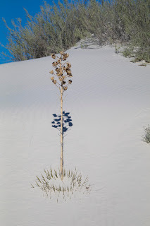
Interesting shadow
Plants include ca
cti and desert succulents that store water through the hot summers and dry winters.

Alkali sacaton and Indian rice grass provide for many tiny animals, including Apache Pocket Mice and Kangaroo Rats. Rodents gather and store dried protein-rich grass seed kernels. Native Americans wove mats with the thicker blades of grass and gathered and ate some grass seeds.

The trees and shrubs in the dunes have exceptionally tall trunks and stems designed to keep leaves in the sunlight above the shifting sands. 

The White Sands gypsum dunefield is 275 square miles in size, but there is only an eight-mile scenic drive (Dunes Drive). 

There are exhibits, hiking trails, picnic areas, vault toilets and parking areas along the route.

The first five miles of Dunes Drive are paved and the last three miles are a hard-packed gypsum sand road. There are frequent signs warning drivers to stay on the road. As if you could drive on those dunes and not get stuck!

Dunes
White Sand abuts the White Sand Missile Range and occasionally the road between White Sands and Las Cruces and the Dunes Drive close during a missile test. There are also warnings that it is possible to find dangerous debris from missile tests.

Every brochure and article we read stressed how easy it is to get lost once you enter the dunefield. We chose not to hike too far beyond the car.

Before we left, we picnicked at one of the iconic shelters ...

A cool vibe
... which have changed little since my first visit in 1958!

That's our car
You can learn more about the park in my earlier blog here.


Trip date: April 6-10, 2017