Sunday, August 4, 2013

Point Reyes

Me at the Point Reyes Lighthouse
A few years ago, when Donna Wilson and I went to Point Reyes National Seashore, we had lots of fog. So much that we couldn't even see where to go to see the lighthouse.

When Caty and I drove over, we were thrilled to have brilliant sunshine. 

Pretty view on the route
We stopped at the Visitors Center and examined all the possible wildlife. We were excited to find out that Elephant Seals live at Point Reyes and disappointed when the Ranger said we wouldn't see any because the had all left for sea. Actually, this Ranger was the most obnoxious, condescending public servant I have ever encountered. He seemed to be mocking us for wanting to see Elephant Seals (granted, we hadn't researched in advance, but we also hadn't had Point Reyes in our original itinerary).

These would be cool to see
So, we rushed to the lighthouse. We were surprised to find that it is only open on Thursday, Friday, Saturday and Sunday. Luckily it was Thursday. On the way, we saw a few fawns.

Mule Deer fawn
Drake Beach
As we got closer to the lighthouse site, it got cloudier and foggier. Since we had heard the fog was supposed to lift, we decided to visit Drake Beach and then go back to the lighthouse later.

Drake Beach
We turned off at the Chimney Rock road because we were curious. It was windy and cold, but the ocean was beautiful, so at the end of the road, we decide the walk down the trail to get some shots. 

We're just here for the view
As we looked down the trail, we saw something moving on the beach. Elephant Seals!!! 

Seem Mr. Ranger Sir was wrong
Elephant Seals fighting!!!

Definitely Elephant Seals
Northern Elephant Seals
The Elephant Seals in California are the Northern species; there is also a Southern species.

Sparring
Hundreds of thousands of Northern Elephant Seals once inhabited the Pacific Ocean, but they were slaughtered wholesale in the 1800s for the oil that could be rendered from their blubber. By 1892, less than 100 were left. The only remaining colony was on the Guadalupe Island off the coast of Baja California. 
In 1922, Mexico gave protected status to Northern Elephant Seals, and the U. S. government followed a few years later when the Seals began to appear in Southern California waters. 

Since that time, Northern Elephant Seals have continued to multiply exponentially, and today, there are approximately 200,000 Northern Elephant Seals.

The Northern Elephant Seal is the second largest Seal in the world, after the Southern Elephant Seal, but there is significant difference between males and females. Males average 5,000 lbs. and 14-16 feet, while females are 900-1,800 lbs. and 9-12 feetCalves can weigh up to 79 lbs and be up to 4 feet long.
 
You can see a calf, bulls and cows here
Another difference between sexes is the bull's large proboscis, reminiscent of an Elephant's trunk (hence the name). 

The bull's proboscis produces extraordinarily loud roaring noises, especially during the mating season, and acts as a rebreather that re-absorbs moisture from exhalations. This is important during the mating season when the Seals do not leave the beach to feed, and must conserve body moisture. 

We could hear them roaring
Elephant Seals are considered "true seals" (as opposed to being Sea Lions) because they have no external ear and very small limbs/flippers. This helps them move easily in the water, but makes navigating on land difficult.

They took the fight into the water, presumably for better maneuverability
They spend 80 percent of their lives underwater in search of food and can cover 60 miles a day when they head out to sea. They can hold their breath for more than 100 minutes, longer than any other non-cetacean mammal , and can dive to over 5,000 feet beneath the ocean's surface. The average depth of their dives is 1,000 to 2,000 feet, typically for around 20 minutes for females and 60 minutes for males. They eat Skates, Rays, Squid, Octopus, Eels, small Sharks and large fish. 

Fighting and resting
Like Whales, Elephant Seals are protected from cold more by their blubber than by fur. Their hair and outer layers of skin molt in large patches. During this time, they are susceptible to the cold and must rest on land in a safe place called a "haul out." 

Haul out
Their average lifespan is only nine years.

Lighthouse
After watching the seals for quite awhile, we headed back to the lighthouse. The fog seemed about the same, but we decided it was now or never, so we walked down the very, very windy road. 

The trees are testament to constant wind from the northwest
Along the walk, there is a nice view of the beach below  ... 

The view disappearing into the fog
... and, later, of the rocks below ...

This is what you expect on the California coast
... plus, you can see the colorful plants and lichen that grows on the rocky cliffs ...

Diverse plants and lichen make for a colorful view
To get to the lighthouse, it's down more than 300 steps plus about an equal amount of ramps along rock cliffs.

It was so foggy on my last trip, I didn't even know about the walk
But, we could see the lighthouse!!! Yay.

And, a cool lighthouse it is
Point Reyes is the most treacherous place along the west coast, so the lighthouse was critical. 

Weather and geology both treacherous
The lighthouse has a fresnel lens, made in France and hand-carried for installation.
 
Considered the best in lighthouse lenses
The lighthouse is now decommissioned, giving way to more easily managed (but ess romantic) warning systems. 

Inside the lighthouse
Now, there is a light station below and foghorns. 

From the decor around the lighthouse, I assume it's a great place to watch for migrating Whales (primarily Gray and Humpback).

A whale mosaic in the courtyard
We didn't see any.

We are so glad we got to see the lighthouse.

A fun place to pose
Up until now, my photo of the area was less than impressive.

Point Reyes, 2011
Moving On
After the lighthouse, we went to Drake Beach with hopes of visiting the Visitors Center and having lunch at the cafe. Both were inexplicably closed (maybe because there "were no Elephant Seals"). 

Just two people walking the beach
So, we threw together a snack and headed north. We stopped at a grocery in Inverness and bought a delicious sandwich and headed to the other side of the park. It's less majestic, but we did see the lovely Pearce historic farm, Tomales Bay ...

Tomales Bay
... and a couple of Tule Elk ...

Just over the crest of the hill
Then, we headed out, driving down the coast towards Muir Woods. We knew it was too late to get there, but we wanted to see sunset on the coast.

Success

Trip date: July 26-August 8, 2013

Yosemite - Big Views, Big Smoke


Half Dome at sunset
Smoke and haze
Early the next morning, we headed into Yosemite. 

It's been years and years since Caty has been there, months since I have. We started at tunnel view  still very smoky from nearby forest fires. In fact, we didn't even take any pictures.

Then, we went into the valley. Because it was mid-summer, it was crazy crowded. The views, while impressive, are too smoky for any decent pictures. We went to the Visitors Center and the Ansel Adams gallery, then bought salads for a picnic. 

We planned to walk to Yosemite Falls, but it was empty. NO water. Yosemite is in a terrible drought  60 percent less rain than last year. We knew the falls got thin late in the summer, but this was crazy!

A Steller's Jay
We decided to drive the Toulomne Road, which was lovely and a bit more crowded than I have ever seen it. We had our picnic at Tenaya Lake. Although the day was warm and sunny, the picnic tables on the lake were a bit breezy and cool. Plus, our salads kept blowing back at us! 

We tried to picnic on the beach
We saw some other lovely lakes as well.

You can see the toll the wind takes on the trees
Mono Lake
As we continued down the road, we decided, what the heck, we were almost there, so we headed out to Mono Lake. It's outside the Park  it is its own park  and quite unusual. 

Mono Lake
Mono Lake a large, shallow saline soda lake formed at least 760,000 years ago as a terminal lake in a basin that has no outlet to the ocean. It has high levels of salts and is very alkaline, which provides a good environment for brine shrimp. It is a habitat for two million annual migratory birds that feed on the shrimp.

Tufa in the foreground
When the city of Los Angeles diverted water from flowing into the lake, it lowered the lake level, which imperiled the migratory birds. The Mono Lake Committee formed in response, winning a legal battle that forced Los Angeles to partially restore the lake level. Now, it is being further restored and will return to its original levels in about 50 years. The lake produces sand-castle-like alkaline formations called tufa. Very interesting.

Back to Yosemite
After Mono Lake, we headed back, stopping at White Wolf campground for a snack from the store (turned out not much was there) and a visit to Bridal Veil Falls. At the Falls, it didn't appear there was any water either, so we decided to move on.

They were warned
In the parking lot, we witnessed the absolute worst tourist behavior possible. 

There was a female Deer in the parking lot that approached some people. We assume she had been fed. Instead of backing away, they pretended to have food to make her follow and once even tried to pet her. We thought for sure we were going to see a deer attack. Don't laugh, they can be very dangerous. We did see her try to kick a woman, but we left before it got ugly. Very disturbing.

Then we made a quick stop at tunnel view. Better than the night before, but still smoky.

A halfway decent photo
We could see that Bridal Veil Falls did have water (a little) in it.

As dry as I have ever seen it
Then, a quick trip to Glacier Point for sunset. We had to hurry, but we made it on time  even with a stop for a coyote sighting. 

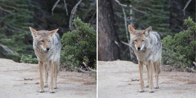
Yosemite Coyotes have aqua eyes
It was still smoky, but a spectacular view of Half Dome. You can't see El Capitan from there. 

Dramatic
I was shocked at how thin both Vernal and Nevada Falls were.

You can see several falls
After the sun set, we were hungry and knew we had a long drive to the Wawona, where we were staying. 

Sunset
We checked our Yosemite newsletter and it appeared our only hope for finding something open for dinner was to go back to the valley and get pizza. By the time we got there, it was dark, dark, dark and there was no parking. So, we decided that Caty would get a pizza while I circled. Right after she left, the very first – very first  parking space opened up. So I caught up with her and we ate at the Pizza Deck. It was delicious. 

It's good pizza; Photo: Tripadvisor
The crowd was a bit odd. There was apparently a big costume party going on. We think it was Yosemite employees.

Then, we drove on to Wawona, getting in around 11.

A full day! 

Two portraits
Plan Change
The next morning, we made a big change in plans. With all the smokiness in Yosemite, we grew concerned about the rest of our trip. 

Photo: Oregon Smoke Information
Caty checked the Internet at a rare time when we had service and learned that there were fires in the Crater Lake area, ou next planned stop. There were reports that the air quality was "hazardous" and that evacuations were likely. 

So, we decided not to proceed north. We canceled hotels in northern California and Crater Lake and decided to head to the coast to visit Point Reyes National Seashore, Muir Woods, San Francisco and Monterey.  

Our next destinations
Hetch Hetchy
Reservations finally made, we decided to explore Hetch Hetchy, "the other Yosemite." So, we drove north through both private land and the Park, passing some camps and lodges along the way.

An old-school mountain camp
This area is historically significant, uncrowded and gorgeous. The valley is very similar to Yosemite, with a cliff that resembles El Capitan. 

Pretty and oddly smoke-free
Back in the late 1880s, the city of San Francisco needed more water and made a move to dam the valley to create a reservoir for the city. Many - including John Muir  opposed the plan. But, back in those days progress trumped preservation and the dam went up  being completed in 1923. The reservoir still serves San Francisco. 

The water that leaves the dam is sent via pipe to the city, using only gravity  no pumps. Further down the route, it is also used to generate power.

Water leaving being released back into the river
Later, moves were made to do the same thing to Yosemite, which led to it being accorded National Park status to protect it.

Native vegetation
Hetch Hetchy is beautiful. 

I am surprised I never went there before
The reservoir (which is closed to swimming and boating) is clear and clean. 

Clear water
The rock cliff incredible and the dam is exceptionally pretty. You can walk across it, through a tunnel in the rock and around the lake.

The tunnel to the trail around the reservoir
The name is probably from a native word hetchhatchie, which means edible grasses. Grass filled the valley before it was dammed.

The trail
After visiting Hetch Hetchy, we drove a very narrow, winding road back to the highway and then headed for Petaluma, where we had decided to stay for our trip to Point Reyes.

Trip date: July 26-August 8, 2013

Friday, August 2, 2013

Big, Big Trees

The General Sherman Tree
So, we saw Earth's biggest animal. Seemed only right to move on to the world's biggest tree. 

Caty and I headed out the Sequoia and Kings Canyon National Park. It was hot, hot, hot, but clear and beautiful. 

We drove from the coast and pressed past the planned stop in Bakersfield 
 I mean, why would anyone stop in Bakersfield? The drive wasn't too bad, but the heat and haze  ick!! 

We stayed at a lovely Holiday Inn in Visalia. Got in late and left early, but it was a nice stop. 

Giant Sequoia NM
Just a big tree by the road
The next morning we decided to explore the Giant Sequoia National Monument. So, we drove and drove through some very yellow/brown fields and then up, up, up a long, winding road. We NEVER saw any evidence we were in the National Monument  just signs we were in the Giant Sequoia National Forest and the state forest. 

It was a lovely drive, but probably a waste of time that could have been spent elsewhere. We did see a – meep, meep – Roadrunner. It was too quick for a photo. We didn't get the anvil, either.

We both had to pose
Sequoia NP
Then, we moved on to Sequoia National Park, where we saw the General Sherman  the biggest tree alive (not the tallest, not the biggest around, but the most mass). It is 275 ft. tall, 25 ft. in diameter  and has an estimated bole volume of 52,513 cubic ft. 

General Sherman is estimated to be 2,300-2,700 years old. 

It is too big to get the whole tree in a photo.

While the General Sherman is the largest currently living tree, it is not the largest tree known to humans. The Crannell Creek Giant, a Coast Redwood near Trinidad, Calif., is estimated to have been 15 to 25 percent larger than the General Sherman tree by volume. The tree was cut down in the mid-1940s.

These trees are old and in sync with the environment
We saw many groves of the massive trees, some cool forests and great mountain vistas. Giant sequoias have very specific climate requirements, so specific that they grow naturally only in a narrow 260-mile strip of mixed conifer forest on the western slopes of the Sierra Nevada mountains, primarily between 5,000 and 7,000 feet in elevation. The National Monument and National Park (plus Kings Canyon) comprise a lot of that area.

It strains the neck to visit (but blows the mind)
A bit hazy from distant fires, but lovely. We saw a Marmot, too.

Yellow-bellied Marmot enjoying a stump perch
When we checked into our cute little cabin, we were greeted by a very large raccoon on the steps. We shooed him away and then wondered why we didn't snap a picture. He was big and somewhat aggressive (we were too freaked out to snap a picture; we heard him hissing even after we went inside).

Kings Canyon NP
The next day, we moved on to Kings Canyon, driving the beautiful road into the heart of the Canyon.

Kings Canyon is more than a mile deep and so, so rugged
We enjoyed both Roaring River Falls and Grizzly Falls. We had a lovely picnic at the latter.

Roaring River, left; Grizzly, right; Grizzly is named after bears that no longer live there
We also visited the General Grant grove, where we saw two adorable fawns.

One of the Mule deer fawns we saw
We eventually saw the tree, too!

Another biggie
About the Parks
Sequoia and Kings Canyon are two National Parks with a combined size of 1,353 square miles. The two Parks feature a wide variety of animals,  200 species of birds and some jaw-dropping scenery.

Kings Canyon is mainly about mountains, rivers and the dramatic canyon
The two adjacent parks extend from the foothills of the San Joaquin Valley to the crest of the Sierra Nevada and contain the highest parts of that range. Pleistocene glaciers left an abrupt topography of granite carved canyons and domes and hundreds of glacial lakes.

The Kings River
Among the peaks is Mount Whitney which, at 14,491 feet, is the tallest mountains in the continental U.S. Other mountains range from elevation of 12,000 feet to 14,000 feet. Sequoia and Kings Canyon house about 200 marble caves (we didn't visit any on this trip, but some are open for tours).

Kings Canyon
The most notable vegetation is forests of giant sequoia. Oak woodland and chaparral with chamise and manzanita characterize the lower elevations. Mixed conifer forest occupy the middle elevations. Subalpine forests typify the higher elevations.

A spider using a decaying sequoia
The area now occupied by the Parks was originally inhabited by Native Americans, who used the mountain passes as trade routes. 

In the late 1800s, land was finally set aside to protect the sequoia trees. 

A dead tree is now a tunnel
After establishing Sequoia National Park, General Grant National Park was created to protect a small area of giant sequoias from logging. 
Environmental groups, visitors and many local politicians wanted to see more area preserved, but developers wanted to build hydroelectric dams in the nearby canyon. After years of conflict, the Cedar Grove and Tehipite Valley dam sites were annexed into the Park. Then, General Grant became Kings Canyon National Park. In 1943, due to proximity and similarities, administration of the Parks was combined.

A downed tree in Sequoia
Because forest fires have become an increasing threat (there were several in progress while we were there),  Park administration conducts controlled burns each year to prevent and reduce future forest fires. 

A Golden-mantled Ground Squirrel
Moving On
After visiting the trees, we pressed north and blew passed the planned stop in Fresno (I feel the same way about Fresno as I do about Bakersfield) and ended up in Mariposa (there was NO lodging available in Yosemite, where we were going next). We checked into the hotel and decided to book it to the Tunnel View overlook to see the Yosemite Valley. A long, winding drive as we tried to beat the clock to sunset. Got there a bit late, but in time for some moody shots. The haze was really thick because of a nearby forest fire. But, Yosemite is still impressive, even when cloaked in schmutz.

Tough visibility
After a few shots, we rushed back as twilight darkened. We rounded a bend and saw a strange animal in the road. Then, we simultaneously realized it was a cat  a small housecat. Not what we expected. About a half an hour later, when it was full dark and we were on a road bounded by mountain on one side and river on the other, we spotted a small animal in the middle of the road. We slammed on the brakes and looked as the headlights lit it up. 

Was it another cat? No, it was a ringtail  something neither of us had ever seen, Then, two more came behind it and they all crossed the road. By their look and the fact that there were three together, we think they were babies. Although they are allegedly common, we've never seen one. It was too dark and too fast for a picture. 

Here's what a baby Ringtail looks like; Photo: LA Zoo

Trip date: July 26-August 8, 2013